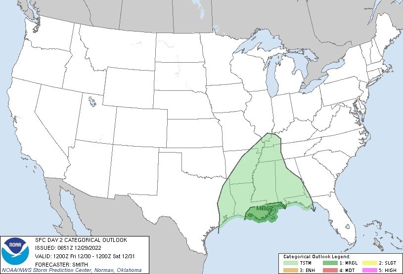
As anticipated, the SPC added a Marginal Risk close tot eh water for tomorrow, everywhere else is looking at mainly just regular storms with some gusty wind and lightning. The concern in the Marginal Risk area close to the Gulf is simply for stronger wind. The tornado threat for tomorrow is very low.
Then, as we move through the weekend and into next week, we face another potential for severe weather on Monday/Tuesday. The SPC has trimmed the Slight Risk back to the northwest for Monday, but the CIPS Analogs shows the threat continuing into Tuesday.

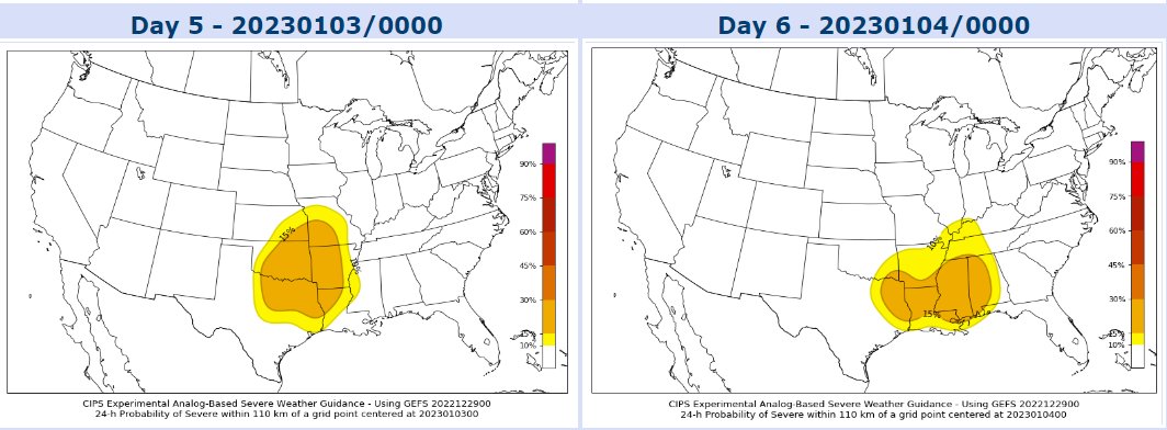
This will be worth monitoring through the weekend, but so far your New Year’s Eve plans look mainly dry and cool.
DAY TO DAY FORECAST
Today
Mostly sunny. Highs in the mid 70s. Southeast winds 10 to 15 mph with gusts up to 25 mph.
Tonight
Mostly clear in the evening, then becoming mostly cloudy. Patchy fog after midnight. Lows in the upper 50s. Southeast winds 5 to 10 mph.
Friday
Cloudy. Patchy fog in the morning. A chance of showers with a slight chance of thunderstorms in the morning, then showers with a chance of thunderstorms in the afternoon. Highs in the lower 70s. Southeast winds 5 to 10 mph with gusts up to 20 mph. Chance of rain 90 percent.
Friday Night
Cloudy. Showers likely with a chance of thunderstorms in the evening, then a chance of showers with a slight chance of thunderstorms after midnight. Patchy fog. Near steady temperature in the lower 60s. South winds 5 to 10 mph. Chance of rain 70 percent.
Saturday
Mostly cloudy with a slight chance of showers and thunderstorms in the morning, then mostly sunny in the afternoon. Highs in the lower 70s. Southwest winds 5 to 10 mph with gusts up to 20 mph. Chance of rain 20 percent.
Saturday Night
Mostly clear in the evening, then becoming partly cloudy. Cooler with lows around 50.
New Years Day
Sunny. Highs in the lower 70s.
Sunday Night
Mostly clear in the evening, then becoming mostly cloudy. Lows in the mid 50s. Temperature rising into the lower 60s after midnight.
Monday
Mostly cloudy with a slight chance of thunderstorms. A chance of showers in the morning, then showers likely in the afternoon. Highs in the mid 70s. Chance of rain 70 percent.
Monday Night
Showers with a slight chance of thunderstorms. Near steady temperature in the mid 60s. Chance of rain 90 percent.
Tuesday
A slight chance of thunderstorms. Showers. Highs in the lower 70s. Chance of rain 80 percent.
Tuesday Night
Showers likely with a slight chance of thunderstorms. Lows in the upper 50s. Chance of rain 70 percent.
Wednesday
Partly sunny with a chance of showers with a slight chance of thunderstorms. Highs in the mid 60s. Chance of rain 40 percent.


