Parts of the region are under a Marginal and Slight Risk for severe weather. Note that the SPC has highlighted areas north and west of south Mississippi with the threat for tornadoes.
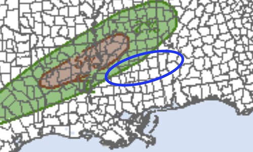
On that risk area, I’ve circled in blue the area I’m watching later this evening.
After looking over some of the latest data, I’m starting to get a bit more concerned about a low-end (pretty low-end, but not zero) threat for a tornado this afternoon and evening (3pm – 8pm) for areas near Jackson, MS and down I-20 to the east toward Meridian, MS. This would include points south to about the HWY 84 corridor, too.
I tend to think this could spread north of I-20 and even south of HWY 84, too, depending on how things line up.

The map above is probably a bit too wide an area, but serves to highlight the places I’m thinking may see a limited, brief threat this evening.

The Karrie Meter map from the lower-resolution GFS shows a stripe of higher numbers – but not significantly high – in the highlighted area. Higher-resolution data is a bit more aggressive with the threat. The HRRR computer weather model as well as the HRW-ARW computer weather model have highlighted this area with a few 50m2/s-2 updraft helicity streaks. And 50 i just about the number we need to start to worry about a low-end tornado threat given the current environment.
I’ve started to trust these UH Streaks more and more recently. While they still aren’t great at pinpointing specific spots, they are useful in identifying a larger area for concern.
Important note
Given how much moisture is in the air, if a tornado did develop it would likely be rain-wrapped and not visible. So if a tornado warning is issued for your area, please don’t look outside to see if you can see it coming – you won’t.
Get to an interior room and listen to the NOAA WEather Radio or a local media outlet for information.
Some Science
As the cold pool from the backside of all of the rain to the north sags south later this afternoon, it will be moving into an area where dewpoint values have surged into the mid- to upper-60s in some places. This surface boundary may act as the focal point for shower and storm initiation.
However, the question remains, just how much ‘umph’ will it provide? Temperatures and dewpoint values on the backside of the cold pool will still be around 60. So the difference from one side to the other may only be a handful of degrees.
If storms can initiate, there will be about 30kts of 0-1km shear for storms to work with. As well as 100-200 m2/s2 of 0-1km sRH values. And while these values aren’t necessarily high, they are high enough to get and keep storms organized.
So if – perhaps a big if – storms develop along this boundary, there is the potential for them to have enough spin in the lowest levels of the atmosphere to get better organized.
In the region, there has been indications that Downdraft CAPE values above 300 need to be reached before even saying the word “tornado” as a possibility. And those values need to be above 600 before a true tornado threat may develop.
Model guidance shows that, in this case, DCAPE values will be between 400 and 500. So just above the lowest numbers, but not quite to a place where there is a true threat.
This all adds up to a pretty marginal and conditional environment for tornadoes. But not a zero threat for sure.


