Another Wednesday, another shot for severe storms across the Gulf Coast. The Storm Prediction Center has highlighted the area with an Enhanced and Slight Risk for severe weather on Wednesday afternoon through early Thursday morning
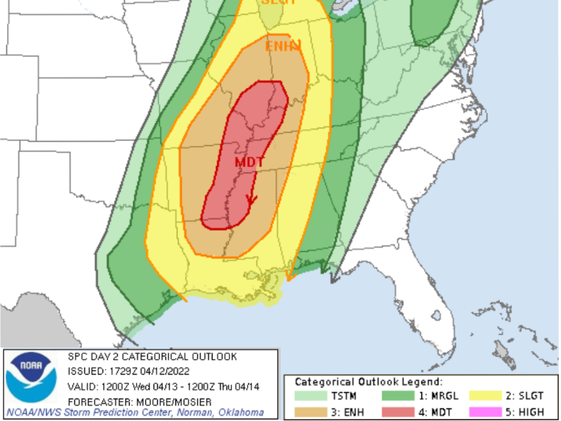
The highest threat for the most severe weather will be across the Midsouth and Ohio River Valley. But the Southern MS/AL/La region will not be in the clear.
For the last few days I’ve been discussing the chances for “two rounds” of severe weather and how I wasn’t fully convinced there would be two distinct rounds. And it turns out my skepticism may have been warranted. It now looks like the “two rounds” may simply bleed together into one extended round of potentially severe storms.


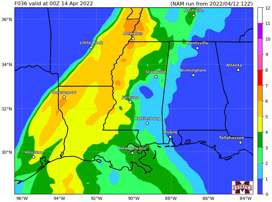
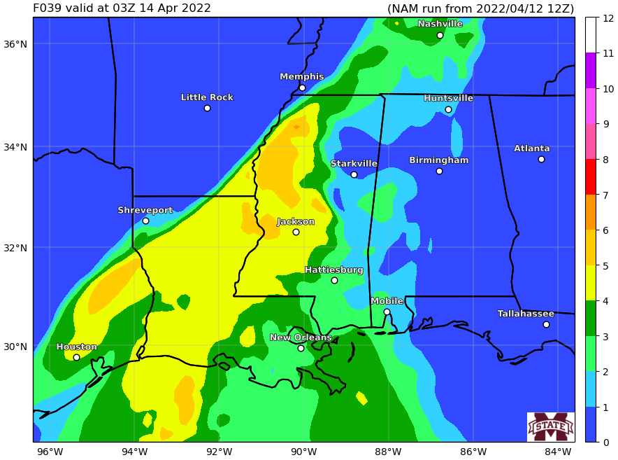
The above montage of images from Pivotal Weather shows the storms starting around 4p on Wednesday and thing lingering around and not really moving through the area until after 1a on Thursday morning.
That means the threat for heavy rain, lightning, wind gusts up to 60mph, small hail and a few tornadoes may persist that entire time for different areas – particularly those on the southern flank of the storms.
Karrie Meter Maps & Risks
The Karrie Meter is showing that the highest risk for severe weather is farther north (exactly where the SPC Risk is highest) with a much lower risk for severe weather farther south across the Southern MS/AL/LA region.

There is a higher risk down south along I-55 and points west through 10p.
The interesting things that has shown up on a few of the models is the development of a cold pool on the northern side of the southern cluster of storms. For those who have been in the area for a while, think back to the March 2016 flooding – that was a similar situation to what some of the models have been showing.
Now — and I want to be very straight forward with this — that doesn’t mean the forecast calls for March 2016 type of flooding. It means that there are some models (including the one above) showing a similar setup.
This time, there isn’t as much moisture in the air, so there won’t be as much rain able to fall. But the estimated totals are still pretty robust.

Try not to get too caught up on specific placement, because that is going to flop around in the modeling. Instead, notice that the yellow and orange areas on the map, which indicate areas the model suggests up to 7″ of rain will fall, are over a relatively broad area. So as that bullseye flops around in the coming days, it may end up flopping closer to you. So keep an eye on low-lying areas and if you live somewhere that has a tendency to flood, keep an extra eye on the local creeks.
Because of this, the WPC has the area highlighted with a Slight Risk for flash flooding.

And one thing to keep in mind, if the cluster of afternoon storms remains disorganized and blobs together quickly, this will quickly change from a severe weather threat to a flooding threat. And then as the cold front arrives overnight, there won’t be as much low-level instability to promote the development of surface-based severe weather (tornadoes) and instead it would just be more rain and wind.
County-by-County Timeline
A quick reminder that this timeline doesn’t mean that the entire time it will be raining and storming. It is an attempt to give you the best window of opportunity for storms to be near you. A three to four hour window may only feature rain and storms for 30-45 minutes. But the goal is to highlight a window where the threat is higher than at other times.
This timeline is likely to change a bit in the coming days, too. So please check back for an update tomorrow as more data comes down and we get a better handle on things. For the moment, here is a look at the threats by general population:
During the highlighted times below, expect to deal with…
EVERYONE — Brief heavy rain, lightning, and wind gusts up to 40mph
MOST PLACES — Brief heavy rain, lightning, and wind gusts up to 45mph
MANY SPOTS — Heavy rain, brief flash flooding, lightning, wind gusts up to 50mph
SOME PEOPLE — Heavy rain, brief localized flooding, wind gusts up to 55mph, small hail
FEW PLACES — Heavy rain, localized flooding, wind gusts exceeding 60mph, small hail, a tornado
Louisiana
St. Helena Parish
Wednesday 3p-6p — Breezy. Isolated showers with few rumbles of thunder developing early, very few (if any) storms may be strong to severe before 4p. Main threats with any storm will be heavy rain, frequent lightning, gusty wind, small hail, and a tornado can not be ruled out.
Wednesday 6p-12a — Showers and storms likely, many strong with a handful severe. Main threats with stronger storms will be very heavy rain, frequent lightning, wind gusts up to 60mph, hail up to the size of quarters, and the potential for a tornado.
Thursday 12a-6a — Storms ending. Turning cooler and breezy.
Tangipahoa Parish
Wednesday 3p-6p — Breezy. Isolated showers with few rumbles of thunder developing early, very few (if any) storms may be strong to severe before 4p. Main threats with any storm will be heavy rain, frequent lightning, gusty wind, small hail, and a tornado can not be ruled out.
Wednesday 6p-12a — Showers and storms likely, many strong with a handful severe. Main threats with stronger storms will be very heavy rain, frequent lightning, wind gusts up to 60mph, hail up to the size of quarters, and the potential for a tornado .
Thursday 12a-6a — Storms ending. Turning cooler and breezy.
Livingston Parish
Wednesday 3p-6p — Breezy. Isolated showers with few rumbles of thunder developing early, very few (if any) storms may be strong to severe before 4p. Main threats with any storm will be heavy rain, frequent lightning, gusty wind, small hail, and a tornado can not be ruled out.
Wednesday 6p-12a — Showers and storms likely, many strong with a handful severe. Main threats with stronger storms will be very heavy rain, frequent lightning, wind gusts up to 60mph, hail up to the size of quarters, and the potential for a tornado.
Thursday 12a-6a — Storms ending. Turning cooler and breezy.
Washington Parish
Wednesday 4p-7p — Breezy. Isolated showers with few rumbles of thunder developing early, very few (if any) storms may be strong to severe before 6p. Main threats with any storm will be heavy rain, frequent lightning, gusty wind, small hail, and a tornado can not be ruled out.
Wednesday 7p-1a — Showers and storms likely, many strong with a handful severe. Main threats with stronger storms will be very heavy rain, frequent lightning, wind gusts up to 60mph, hail up to the size of quarters, and the potential for a tornado.
Thursday 1a-7a — Storms ending. Turning cooler and breezy.
St. Tammany Parish
Wednesday 4p-7p — Breezy. Isolated showers with few rumbles of thunder developing early, very few (if any) storms may be strong to severe before 6p. Main threats with any storm will be heavy rain, frequent lightning, gusty wind, small hail, and a tornado can not be ruled out.
Wednesday 7p-1a — Showers and storms likely, many strong with a handful severe. Main threats with stronger storms will be very heavy rain, frequent lightning, wind gusts up to 60mph, hail up to the size of quarters, and the potential for a tornado.
Thursday 1a-7a — Storms ending. Turning cooler and breezy.
Mississippi
NEAR I-20
Copiah County
Wednesday 4p-7p — Breezy. Isolated showers with few rumbles of thunder developing early, very few (if any) storms may be strong to severe before 6p. Main threats with any storm will be heavy rain, frequent lightning, gusty wind, small hail, and a tornado can not be ruled out.
Wednesday 7p-1a — Showers and storms likely, many strong with a handful severe. Main threats with stronger storms will be very heavy rain, frequent lightning, wind gusts up to 60mph, hail up to the size of quarters, and the potential for a tornado.
Thursday 1a-7a — Storms ending. Turning cooler and breezy.
Simpson County
Wednesday 4p-7p — Breezy. Isolated showers with few rumbles of thunder developing early, very few (if any) storms may be strong to severe before 6p. Main threats with any storm will be heavy rain, frequent lightning, gusty wind, small hail, and a tornado can not be ruled out.
Wednesday 7p-1a — Showers and storms likely, many strong with a handful severe. Main threats with stronger storms will be very heavy rain, frequent lightning, wind gusts up to 60mph, hail up to the size of quarters, and the potential for a tornado.
Thursday 1a-7a — Storms ending. Turning cooler and breezy.
Smith County
Wednesday 4p-7p — Breezy. Isolated showers with few rumbles of thunder developing early, very few (if any) storms may be strong to severe before 6p. Main threats with any storm will be heavy rain, frequent lightning, gusty wind, small hail, and a tornado can not be ruled out.
Wednesday 7p-1a — Showers and storms likely, many strong with a handful severe. Main threats with stronger storms will be very heavy rain, frequent lightning, wind gusts up to 60mph, hail up to the size of quarters, and the potential for a tornado.
Thursday 1a-7a — Storms ending. Turning cooler and breezy.
Jasper County
Wednesday 5p-8p — Breezy. Isolated showers with few rumbles of thunder developing early, very few (if any) storms may be strong to severe before 6p. Main threats with any storm will be heavy rain, frequent lightning, gusty wind, small hail, and a tornado can not be ruled out.
Wednesday 8p-2a — Showers and storms likely, many strong with a handful severe. Main threats with stronger storms will be very heavy rain, frequent lightning, wind gusts up to 60mph, hail up to the size of quarters, and the potential for a tornado.
Thursday 2a-8a — Storms ending. Turning cooler and breezy.
Clarke County
Wednesday 6p-9a — Breezy. Isolated showers with few rumbles of thunder developing early, very few (if any) storms may be strong to severe before 9p. Main threats with any storm will be heavy rain, frequent lightning, gusty wind, small hail, and a tornado can not be ruled out.
Wednesday 9a-3a — Showers and storms likely, many strong with a handful severe. Main threats with stronger storms will be very heavy rain, frequent lightning, wind gusts up to 60mph, hail up to the size of quarters, and the potential for a tornado.
Thursday 3a-9a — Storms ending. Turning cooler and breezy.
HIGHWAY 84 CORRIDOR
Lincoln County
Wednesday 4p-7p — Breezy. Isolated showers with few rumbles of thunder developing early, very few (if any) storms may be strong to severe before 6p. Main threats with any storm will be heavy rain, frequent lightning, gusty wind, small hail, and a tornado can not be ruled out.
Wednesday 7p-1a — Showers and storms likely, many strong with a handful severe. Main threats with stronger storms will be very heavy rain, frequent lightning, wind gusts up to 60mph, hail up to the size of quarters, and the potential for a tornado.
Thursday 1a-7a — Storms ending. Turning cooler and breezy.
Lawrence County
Wednesday 4p-7p — Breezy. Isolated showers with few rumbles of thunder developing early, very few (if any) storms may be strong to severe before 6p. Main threats with any storm will be heavy rain, frequent lightning, gusty wind, small hail, and a tornado can not be ruled out.
Wednesday 7p-1a — Showers and storms likely, many strong with a handful severe. Main threats with stronger storms will be very heavy rain, frequent lightning, wind gusts up to 60mph, hail up to the size of quarters, and the potential for a tornado.
Thursday 1a-7a — Storms ending. Turning cooler and breezy.
Jeff Davis County
Wednesday 4p-7p — Breezy. Isolated showers with few rumbles of thunder developing early, very few (if any) storms may be strong to severe before 7p. Main threats with any storm will be heavy rain, frequent lightning, gusty wind, small hail, and a tornado can not be ruled out.
Wednesday 7p-1a — Showers and storms likely, many strong with a handful severe. Main threats with stronger storms will be very heavy rain, frequent lightning, wind gusts up to 60mph, hail up to the size of quarters, and the potential for a tornado.
Thursday 1a-7a — Storms ending. Turning cooler and breezy.
Covington County
Wednesday 5p-8p — Breezy. Isolated showers with few rumbles of thunder developing early, very few (if any) storms may be strong to severe before 7p. Main threats with any storm will be heavy rain, frequent lightning, gusty wind, small hail, and a tornado can not be ruled out.
Wednesday 8p-2a — Showers and storms likely, many strong with a handful severe. Main threats with stronger storms will be very heavy rain, frequent lightning, wind gusts up to 60mph, hail up to the size of quarters, and the potential for a tornado.
Thursday 2a-8a — Storms ending. Turning cooler and breezy.
Jones County
Wednesday 5p-8p — Breezy. Isolated showers with few rumbles of thunder developing early, very few (if any) storms may be strong to severe before 7p. Main threats with any storm will be heavy rain, frequent lightning, gusty wind, small hail, and a tornado can not be ruled out.
Wednesday 8p-2a — Showers and storms likely, many strong with a handful severe. Main threats with stronger storms will be very heavy rain, frequent lightning, wind gusts up to 60mph, hail up to the size of quarters, and the potential for a tornado.
Thursday 2a-8a — Storms ending. Turning cooler and breezy.
Wayne County
Wednesday 6p-9a — Breezy. Isolated showers with few rumbles of thunder developing early, very few (if any) storms may be strong to severe before 9p. Main threats with any storm will be heavy rain, frequent lightning, gusty wind, small hail, and a tornado can not be ruled out.
Wednesday 9a-3a — Showers and storms likely, many strong with a handful severe. Main threats with stronger storms will be very heavy rain, frequent lightning, wind gusts up to 60mph, hail up to the size of quarters, and the potential for a tornado.
Thursday 3a-9a — Storms ending. Turning cooler and breezy.
HIGHWAY 98 CORRIDOR
Pike County
Wednesday 4p-7p — Breezy. Isolated showers with few rumbles of thunder developing early, very few (if any) storms may be strong to severe before 6p. Main threats with any storm will be heavy rain, frequent lightning, gusty wind, small hail, and a tornado can not be ruled out.
Wednesday 7p-1a — Showers and storms likely, many strong with a handful severe. Main threats with stronger storms will be very heavy rain, frequent lightning, wind gusts up to 60mph, hail up to the size of quarters, and the potential for a tornado.
Thursday 1a-7a — Storms ending. Turning cooler and breezy.
Walthall County
Wednesday 4p-7p — Breezy. Isolated showers with few rumbles of thunder developing early, very few (if any) storms may be strong to severe before 6p. Main threats with any storm will be heavy rain, frequent lightning, gusty wind, small hail, and a tornado can not be ruled out.
Wednesday 7p-1a — Showers and storms likely, many strong with a handful severe. Main threats with stronger storms will be very heavy rain, frequent lightning, wind gusts up to 60mph, hail up to the size of quarters, and the potential for a tornado.
Thursday 1a-7a — Storms ending. Turning cooler and breezy.
Marion County
Wednesday 5p-8p — Breezy. Isolated showers with few rumbles of thunder developing early, very few (if any) storms may be strong to severe before 7p. Main threats with any storm will be heavy rain, frequent lightning, gusty wind, small hail, and a tornado can not be ruled out.
Wednesday 8p-2a — Showers and storms likely, many strong with a handful severe. Main threats with stronger storms will be very heavy rain, frequent lightning, wind gusts up to 60mph, hail up to the size of quarters, and the potential for a tornado.
Thursday 2a-8a — Storms ending. Turning cooler and breezy.
Lamar County
Wednesday 5p-8p — Breezy. Isolated showers with few rumbles of thunder developing early, very few (if any) storms may be strong to severe before 7p. Main threats with any storm will be heavy rain, frequent lightning, gusty wind, small hail, and a tornado can not be ruled out.
Wednesday 8p-2a — Showers and storms likely, many strong with a handful severe. Main threats with stronger storms will be very heavy rain, frequent lightning, wind gusts up to 60mph, hail up to the size of quarters, and the potential for a tornado.
Thursday 2a-8a — Storms ending. Turning cooler and breezy.
Forrest County
Wednesday 5p-8p — Breezy. Isolated showers with few rumbles of thunder developing early, very few (if any) storms may be strong to severe before 7p. Main threats with any storm will be heavy rain, frequent lightning, gusty wind, small hail, and a tornado can not be ruled out.
Wednesday 8p-2a — Showers and storms likely, many strong with a handful severe. Main threats with stronger storms will be very heavy rain, frequent lightning, wind gusts up to 60mph, hail up to the size of quarters, and the potential for a tornado.
Thursday 2a-8a — Storms ending. Turning cooler and breezy.
Perry County
Wednesday 7p-1a — Breezy. Isolated showers with few rumbles of thunder developing early, very few (if any) storms may be strong to severe before 9p. Main threats with any storm will be heavy rain, frequent lightning, gusty wind, small hail, and a tornado can not be ruled out.
Wednesday 1a-4a — Showers and storms likely, many strong with a handful severe. Main threats with stronger storms will be very heavy rain, frequent lightning, wind gusts up to 60mph, hail up to the size of quarters, and the potential for a tornado.
Thursday 4a-10a — Storms ending. Turning cooler and breezy.
Greene County
Wednesday 7p-1a — Breezy. Isolated showers with few rumbles of thunder developing early, very few (if any) storms may be strong to severe before 9p. Main threats with any storm will be heavy rain, frequent lightning, gusty wind, small hail, and a tornado can not be ruled out.
Wednesday 1a-4a — Showers and storms likely, many strong with a handful severe. Main threats with stronger storms will be very heavy rain, frequent lightning, wind gusts up to 60mph, hail up to the size of quarters, and the potential for a tornado.
Thursday 4a-10a — Storms ending. Turning cooler and breezy.
HIGHWAY 26 CORRIDOR
Pearl River County
Wednesday 4p-7p — Breezy. Isolated showers with few rumbles of thunder developing early, very few (if any) storms may be strong to severe before 6p. Main threats with any storm will be heavy rain, frequent lightning, gusty wind, small hail, and a tornado can not be ruled out.
Wednesday 7p-1a — Showers and storms likely, many strong with a handful severe. Main threats with stronger storms will be very heavy rain, frequent lightning, wind gusts up to 60mph, hail up to the size of quarters, and the potential for a tornado.
Thursday 1a-7a — Storms ending. Turning cooler and breezy.
Stone County
Wednesday 5p-8p — Breezy. Isolated showers with few rumbles of thunder developing early, very few (if any) storms may be strong to severe before 8p. Main threats with any storm will be heavy rain, frequent lightning, gusty wind, small hail, and a tornado can not be ruled out.
Wednesday 8p-2a — Showers and storms likely, many strong with a handful severe. Main threats with stronger storms will be very heavy rain, frequent lightning, wind gusts up to 60mph, hail up to the size of quarters, and the potential for a tornado.
Thursday 2a-8a — Storms ending. Turning cooler and breezy.
George County
Wednesday 7p-1a — Breezy. Isolated showers with few rumbles of thunder developing early, very few (if any) storms may be strong to severe before 9p. Main threats with any storm will be heavy rain, frequent lightning, gusty wind, small hail, and a tornado can not be ruled out.
Wednesday 1a-5a — Showers and storms likely, many strong with a handful severe. Main threats with stronger storms will be very heavy rain, frequent lightning, wind gusts up to 60mph, hail up to the size of quarters, and the potential for a tornado.
Thursday 5a-11a — Storms ending. Turning cooler and breezy.
COASTAL MISSISSIPPI
Jackson County
Wednesday 7p-1a — Breezy. Isolated showers with few rumbles of thunder developing early, very few (if any) storms may be strong to severe before 9p. Main threats with any storm will be heavy rain, frequent lightning, gusty wind, small hail, and a tornado can not be ruled out.
Wednesday 1a-5a — Showers and storms likely, many strong with a handful severe. Main threats with stronger storms will be very heavy rain, frequent lightning, wind gusts up to 60mph, hail up to the size of quarters, and the potential for a tornado.
Thursday 5a-11a — Storms ending. Turning cooler and breezy.
Harrison County
Wednesday 7p-1a — Breezy. Isolated showers with few rumbles of thunder developing early, very few (if any) storms may be strong to severe before 9p. Main threats with any storm will be heavy rain, frequent lightning, gusty wind, small hail, and a tornado can not be ruled out.
Wednesday 1a-5a — Showers and storms likely, many strong with a handful severe. Main threats with stronger storms will be very heavy rain, frequent lightning, wind gusts up to 60mph, hail up to the size of quarters, and the potential for a tornado.
Thursday 5a-11a — Storms ending. Turning cooler and breezy.
Hancock County
Wednesday 7p-1a — Breezy. Isolated showers with few rumbles of thunder developing early, very few (if any) storms may be strong to severe before 9p. Main threats with any storm will be heavy rain, frequent lightning, gusty wind, small hail, and a tornado can not be ruled out.
Wednesday 1a-5a — Showers and storms likely, many strong with a handful severe. Main threats with stronger storms will be very heavy rain, frequent lightning, wind gusts up to 60mph, hail up to the size of quarters, and the potential for a tornado.
Thursday 5a-11a — Storms ending. Turning cooler and breezy.
Alabama
Sumter County
Wednesday 7p-1a — Breezy. Isolated showers with few rumbles of thunder developing early, very few (if any) storms may be strong to severe before 9p. Main threats with any storm will be heavy rain, frequent lightning, gusty wind, small hail, and a tornado can not be ruled out.
Wednesday 1a-5a — Showers and storms likely, many strong with a handful severe. Main threats with stronger storms will be very heavy rain, frequent lightning, wind gusts up to 60mph, hail up to the size of quarters, and the potential for a tornado.
Thursday 5a-11a — Storms ending. Turning cooler and breezy.
Choctaw County
Wednesday 7p-1a — Breezy. Isolated showers with few rumbles of thunder developing early, very few (if any) storms may be strong to severe before 9p. Main threats with any storm will be heavy rain, frequent lightning, gusty wind, small hail, and a tornado can not be ruled out.
Wednesday 1a-5a — Showers and storms likely, many strong with a handful severe. Main threats with stronger storms will be very heavy rain, frequent lightning, wind gusts up to 60mph, hail up to the size of quarters, and the potential for a tornado.
Thursday 5a-11a — Storms ending. Turning cooler and breezy.
Washington County
Wednesday 7p-1a — Breezy. Isolated showers with few rumbles of thunder developing early, very few (if any) storms may be strong to severe before 9p. Main threats with any storm will be heavy rain, frequent lightning, gusty wind, small hail, and a tornado can not be ruled out.
Wednesday 1a-5a — Showers and storms likely, many strong with a handful severe. Main threats with stronger storms will be very heavy rain, frequent lightning, wind gusts up to 60mph, hail up to the size of quarters, and the potential for a tornado.
Thursday 5a-11a — Storms ending. Turning cooler and breezy.


