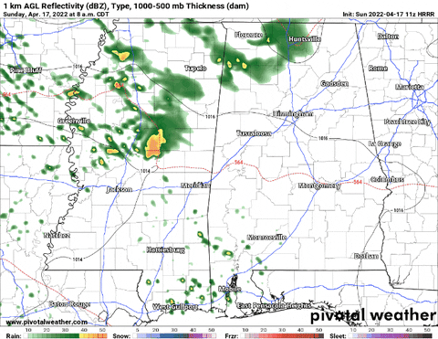
Showers and storms this morning are all north of I-20 and drifting to the southeast. They will eventually impact places like Meridian, northern Jasper, Clarke, Lauderdale and Newton counties. Otherwise, storms should remain – mainly – to the north of the area through about 1p this afternoon.

Then as we head into the afternoon more widespread showers and storms will develop across the region.
The Data
The 11z HRRR model data seemed to have a pretty good handle on how things will progress during the next 18 hours.
The showers and storms will begin as early as 4p and last through about 10p tongiht as they drift south into the Gulf of Mexico.
The SPC has highlighted the area with the potential for severe weather.


While severe weather is possible, the threat for tornadoes will be pretty low. Not zero, but it will take Mary Poppins-like set of events (practically perfect in every way) in order to pull one out of the clouds. The SPC has part of the area with a 5-percent Tornado Risk but that may be a bit high.

Comparing the numbers above to historical averages below, you can start to see where things don’t line up well. There will be plenty of CAPE (1), sure, but it is almost too much. At 1800J/kg, it is well beyond the highest whisker on the Box-and-Whisker plot below. Shear?(4,5) Plenty within the storm, but there isn’t as much in the bottom 3,000 meters according to the wind profile (6), While the LCL (3), EIL (7), and DCAPE (2) are sufficient, the forcing (8) is mostly in the mid-levels with very little at the surface.

Plus, storm motion today will be from WNW to ESE. That, historically, limits the tornado threat and increases the hail threat simply by how things in the storms are arranged.
That doesn’t mean a tornado can’t happen, it will just be more difficult today.
Instead, a bit like the other day, I think hail and gusty wind are the larger concerns for today. The SPC agrees. It shows a hatched area for larger hail across parts of Louisiana and Mississippi.
During this (and previous) event, people have asked if there is a way to “‘help’ or ‘say thanks’ for all of the forecasting work I do. For the longest time I said, ‘nah! I just like doing this! You know, to help!’ But I was recently convinced that others want to ‘help’ in their own way, too.
And their way of helping, or simply saying ‘thank you’ is with a donation to the blog to help keep it running – or to help keep me running. So I’ve added this link. If you are one of those people, let me say thank you to YOU.
The Bottom Line
THREATS
EVERYONE — Passing showers with rumbles of thunder and a few wind gusts up to 30mph
MOST PLACES — Brief heavy rain, lightning, and wind gusts up to 40mph
MANY SPOTS — Brief heavy rain, lightning, wind gusts up to 45mph, and pea-sized hail
SOME PEOPLE — Heavy rain, brief localized flooding, wind gusts up to 50mph, quarter-sized hail
FEW PLACES — Heavy rain, localized flooding, wind gusts exceeding 60mph, golf ball-sized hail, a brief tornado
TIMELINE
— 1p through 4p: Isolated storms with brief heavy rain, lightning, gusty wind and small hail possible
— 4p through 10p: Scattered storms heavy rain, lightning, gusty wind and small hail possible. Plus a few severe storms possible with hail up to the size of ping pong balls and the potential for a tornado
— 10p through 2a: Storms ending


There are no words to describe how reassuring it is to hear your voice LIVE during a severe weather event Nick Lilja! Thank you so much for ALL you do for South MS!