Currently, after a very hot and humid day, the Pinebelt may see another chance of severe weather overnight. A low pressure zone is currently moving through the Tennessee Valley eastward and will bring with it a shot of storms coming in from the northwest. Most of these storms will affect central Mississippi and will lose intensity as they come further south towards the Highway 98 corridor. The SPC has placed the Highway 98 corridor under a Marginal risk, while areas north will be under a slight risk since the storms will reach their peak north of the I-20 corridor. Lightning, hail, and wind will be the main concern as well as flash flooding. These storms will come through after midnight until around 3 in the morning.
The closed low will move northeast on Monday, however, the front will stall over Mississippi for the next couple of days which will cause more storms to occur. Our main concern is Monday afternoon as we will reach the peak of our daytime heat, and it will be a big contributor to the intensity of the thunderstorms that will develop. Looking at the RAP and the HRRR models, they both insinuate straightline winds with all of them pulling from the west and with some dry slots in the Skew-T’s, up to golf ball sized hail will also be possible around the Pinebelt. The timing of these storms looks to be in the mid-afternoon to the evening as these storms will move southward towards the coast.

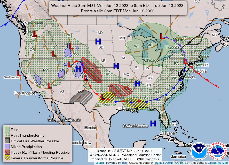
Looking into Tuesday, the SPC has put most of Mississippi into a marginal risk for severe storms. These storms will not be as intense as Monday, however, some strong thunderstorms may develop from the north again and move into our neck of the woods. A sub-tropical ridge is also in development which will pull in winds from the south which will keep the Deep South very hot and very humid for several days. Temperatures will climb into the middle and upper 90s with heat indices reaching into the 100s by the end of the week. Please stay hydrated if you are working outdoors!
Wednesday through Friday has multiple storm systems possible which means scattered rain and thunderstorms are possible especially in the afternoon. As we move into the weekend, temperatures will begin to climb into the upper 90s with even higher heat indices reaching the 100s as the subtropical high will remain over us for a while.
[wpcode id=”41179″]
Regional Day-to-Day Forecast
Tonight – A 30 percent chance of showers and thunderstorms, mainly before 1am. Increasing clouds, with a low around 72. South southwest wind 5 to 10 mph.
Monday – Showers and thunderstorms likely, mainly between 2pm and 4pm. Some of the storms could be severe. Partly sunny, with a high near 92. Heat index values as high as 102. West wind 5 to 10 mph, with gusts as high as 20 mph. Chance of precipitation is 60%. New rainfall amounts between a tenth and quarter of an inch, except higher amounts possible in thunderstorms.
Monday Night – A 30 percent chance of showers and thunderstorms, mainly before 1am. Some of the storms could be severe. Partly cloudy, with a low around 70. Northwest wind around 5 mph becoming calm in the evening.
Tuesday – A 30 percent chance of showers and thunderstorms, mainly after 1pm. Partly sunny, with a high near 93. Heat index values as high as 99. Light south southwest wind becoming southwest 5 to 10 mph in the morning. Winds could gust as high as 20 mph.
Tuesday Night – A 30 percent chance of showers and thunderstorms, mainly before 1am. Mostly cloudy, with a low around 72. South southwest wind around 5 mph, with gusts as high as 20 mph.
Wednesday – A 50 percent chance of showers and thunderstorms. Mostly sunny, with a high near 93. Southwest wind 5 to 10 mph, with gusts as high as 25 mph. New rainfall amounts of less than a tenth of an inch, except higher amounts possible in thunderstorms.
Wednesday Night – A 40 percent chance of showers and thunderstorms. Partly cloudy, with a low around 70. West wind around 5 mph becoming east in the evening.
Thursday – A 50 percent chance of showers and thunderstorms. Mostly sunny, with a high near 95. West southwest wind 5 to 10 mph, with gusts as high as 20 mph.
Thursday Night – A 40 percent chance of showers and thunderstorms, mainly before 1am. Mostly clear, with a low around 72. South southwest wind around 5 mph becoming calm in the evening.
Friday – A 40 percent chance of showers and thunderstorms. Sunny, with a high near 95.
Friday Night – A 30 percent chance of showers and thunderstorms. Partly cloudy, with a low around 73.
Saturday – A 40 percent chance of showers and thunderstorms. Mostly sunny and hot, with a high near 97.
Saturday Night – A 30 percent chance of showers and thunderstorms. Partly cloudy, with a low around 73.
Sunday – A 40 percent chance of showers and thunderstorms. Mostly sunny and hot, with a high near 97.
[wpcode id=”41149″]


