Though we had a break from some of the severe weather today, tomorrow brings a couple of rounds of thunderstorms throughout the day. With a surface low pressure zone just over Arkansas, this will provide enough movement for the storms to beeline towards much of Mississippi, Alabama, and Florida on Sunday. Plenty of instability that has been established today due to the prolonged period of sun will help fuel the overnight systems.

The two systems are mesoscale convective systems that will develop from the drylines in Texas and push east overnight into the deep south. The first system will move in during the early morning hours into around 7 am. The second system will develop a couple of hours behind it and move in during the mid-morning into the early afternoon. A third round of storms will come in after sunset with some scattered thunderstorms across central Louisiana and southern Mississippi.

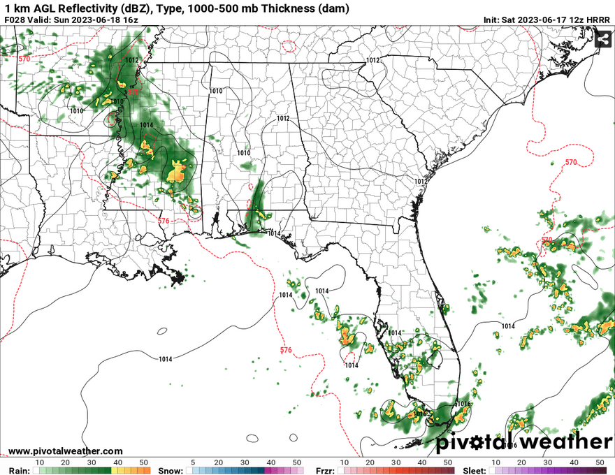
Our main concerns for tomorrow will be straightline winds and flash flooding. With PWAT values spiking with these storms, we should expect a lot of rain with any severe storm that develops. Rain values could reach over 2 inches in some areas for all three rounds of storms.

Looking into Monday, the front will start to move the rain chances further eastward into Alabama and Georgia and will continue to as the low out west will move further southeast. Rain and thunderstorms are possible for the eastern end of Mississippi and will push further south during the day.
As the front settles down towards the coastline, we will see fairly seasonable temperatures later in the week. This doesn’t mean that rain chances will completely diminish, however, as there will still be isolated and scattered rain chances, however the severe chances will be diminished.
[wpcode id=”41179″]
Regional Day-to-Day Forecast
Tonight – A 20 percent chance of showers and thunderstorms before 7pm. Partly cloudy, with a low around 71. West northwest wind around 5 mph becoming calm in the evening.
Sunday – Showers and thunderstorms likely, mainly between 7am and 8am. Partly sunny, with a high near 92. Heat index values as high as 103. Light and variable wind becoming south 5 to 10 mph in the morning. Chance of precipitation is 60%. New rainfall amounts between a tenth and quarter of an inch, except higher amounts possible in thunderstorms.
Sunday Night – A 40 percent chance of showers and thunderstorms. Some of the storms could be severe. Mostly cloudy, with a low around 73. South southeast wind around 5 mph becoming calm in the evening. Winds could gust as high as 20 mph.
Juneteenth – A chance of showers, then showers and thunderstorms likely after 10am. Mostly sunny, with a high near 93. Heat index values as high as 106. Southwest wind 5 to 10 mph becoming west northwest in the afternoon. Winds could gust as high as 20 mph. Chance of precipitation is 70%. New rainfall amounts between a tenth and quarter of an inch, except higher amounts possible in thunderstorms.
Monday Night – A 40 percent chance of showers and thunderstorms before 1am. Partly cloudy, with a low around 72. West wind around 5 mph becoming calm.
Tuesday – A slight chance of showers, then a chance of showers and thunderstorms after 10am. Sunny, with a high near 92. Light west wind increasing to 5 to 10 mph in the morning. Winds could gust as high as 20 mph. Chance of precipitation is 50%. New rainfall amounts between a tenth and quarter of an inch, except higher amounts possible in thunderstorms.
Tuesday Night – A 30 percent chance of showers and thunderstorms before 1am. Mostly clear, with a low around 70. West wind around 5 mph becoming calm.
Wednesday – A 50 percent chance of showers and thunderstorms, mainly after 1pm. Mostly sunny, with a high near 89. North wind around 5 mph.
Wednesday Night – A 20 percent chance of showers and thunderstorms before 1am. Partly cloudy, with a low around 69. North northeast wind around 5 mph becoming calm.
Thursday – A 50 percent chance of showers and thunderstorms, mainly after 1pm. Mostly sunny, with a high near 86.
Thursday Night – A 30 percent chance of showers and thunderstorms. Partly cloudy, with a low around 69.
Friday – A 50 percent chance of showers and thunderstorms. Mostly sunny, with a high near 87.
Friday Night – A 20 percent chance of showers and thunderstorms. Partly cloudy, with a low around 69.
Saturday – A 40 percent chance of showers and thunderstorms. Mostly sunny, with a high near 90.
[wpcode id=”41149″]


