I’m going to start with some EPMD, “Never Seen Before” because “I’m back with the flyest material” of a snippet of Satellite imagery showing a subtropical system off the coast of Uruguay in South America.
For those of you who are not familiar with EPMD or Southern Hemisphere tropical systems, don’t worry. They are both rather rare to hear about. We can discuss EPMD another day, today I want to focus on the tropics. So, as far as tropical cyclones south of the Equator, there have been about 40 since 2000.
This is Subtropical Storm Raoni. It even got the WPC’s attention up here. In their discussion about South America they wrote:
…WITH SURFACE FRONT EXTENDING TO THE NORTHWEST ACROSS SAO PAULO-MATO GROSSO IN BRASIL TO BOLIVIA. THE OCCLUDED LOW…AS IT MEANDERS OVER WARMER THAN NORMAL SEA SURFACE TEMPERATURES…COULD EVOLVE INTO A SUBTROPICAL CYCLONE LATER TODAY. IF IT DOES…WARNINGS WILL BE ISSUED BY THE SERVICO DE MARINHA DO BRASIL. CONDITIONS ARE TO REMAIN FAVORABLE THROUGH TUESDAY EVENING…THEN QUICKLY GROW HOSTILE ON WEDNESDAY.
Courtesy: wpc.noaa.gov
And looking back through the satellite data, most of the tropical systems coming off the South American coast don’t have a very apparent eye like this one. In fact, the last one that looked like this was Catarina in 2004. Even though this system isn’t fully tropical, it is neat to see an eye-like feature like the one it developed.
So, just know when you watch TV and the anchor says, “this is rare event…” they aren’t – necessarily – exaggerating but it isn’t really rare. There are about one or two per year.
If someone said, “this rare event in December called “Christmas” is happening again” you’d stop and say, “Christmas isn’t rare, it happens every year.” and you’d be right.
But compared to, say, 30 tropical cyclones per year (like we had north of the Equator last year) sure it is a rare event to only have one.
Ain’t nothin’ but an Invest party
There are two areas of interest out the open Atlantic that the national Hurricane Center is monitoring. Invest 95L and Invest 97L.

A quick reminder that an “Invest” is simply an area of INVESTigation that the NHC is monitoring for potential development in the coming days. And it is an area worth extra attention, so they run computer models for these areas to try and get a better idea about if they will develop into a tropical cyclone or not.
Invest 95L (west) and Invest 97L (east) are moving toward the west at 10mph to 20mph and the NHC says there is a chance that either one or both develop into some sort of tropical system.
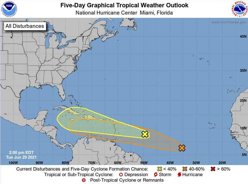
1. Disorganized showers and thunderstorms continue in association with a tropical wave located over the tropical Atlantic about 650 miles east of the Lesser Antilles. Some slow development of this disturbance is possible later this week while the system moves westward to west-northwestward at 20 to 25 mph, likely reaching the Lesser Antilles by Wednesday night. Regardless of development, this system could bring locally heavy rainfall to portions of the Lesser Antilles during the next few days.
* Formation chance through 48 hours…low…20 percent.
* Formation chance through 5 days…low…30 percent.2. Shower activity associated with a tropical wave located about 900 miles southwest of the Cabo Verde Islands continues to show signs of organization. Additional development of this system is possible during the next several days as it moves generally west- northwestward at about 20 mph.
* Formation chance through 48 hours…low…20 percent.
* Formation chance through 5 days…medium…40 percent.
Model guidance is a bit torn in terms of development, but there is a chance that one – or both – end up in or near the Gulf of Mexico eventually.
Model Data
Before we jump head first into the data, do know that this is the super-early data and neither of these systems have developed into much yet. So most of the models are going to struggle to accurately predict what may happen. This is why humans are an important part of the actual forecast at this point – and every point, truly – in the life cycle of these tropical systems.
Track guidance from the suite of tropical models takes both of these through the Graveyard of the Atlantic, the Caribbean Sea.


It is interesting to note that each of the above graphics are not showing spaghetti plots out to a specific time. The Invest 95L spaghettis go out 120 hours. The Invest 97L go out 168 hours.
So, yes, there is a chance that these are going to train their way through the Caribbean, on after the other.
Ensemble guidance from the GEFS and EPS show a similar trek for Invest 95L


For Invest 97L there are – at this time – only ensemble plots from the GEFS.

The good news is that model guidance for intensity (while not perfect in general, and not much good beyond 72 hours) shows that Invest 95L is going to struggle to do much, and 97L has the better chance of being the only game in town.


Water Temperatures
In a word: Warm.
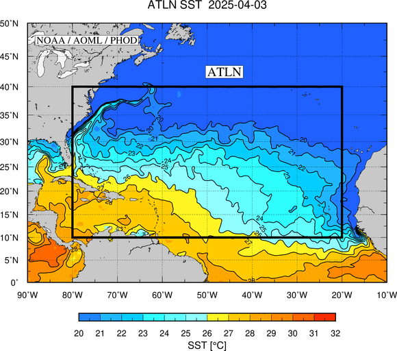
In many words: The waters of the Caribbean and Gulf of Mexico are not as warm as they could be, but are still warm enough for tropical development.


The Bottom Line
At this point, the bottom line is that now is the time to double-check that Hurricane Preparedness Kit. Make sure that you’ve got enough water, food and supplies to last for a week. Look around the outside of your home and clear away any loose branches and dead shrubs. And trim the trees and shrubs that have branches close to your home.
And keep up with the forecast in the coming days. But also know that this will not… repeating here … this will not interfere with any of your Fourth of July outdoor plans – directly.
It may make traffic an extra pain in the backside if people are leaving early from their destinations to “beat everyone back” to their respective homes. And it may make your weekend less enjoyable because you may be wondering what is going to happen out in the tropics.
But neither system is moving fast enough to get to the coast of the United States by the Fourth of July.
But it may be pretty shortly thereafter if things shake out like some of the guidance is suggesting.


