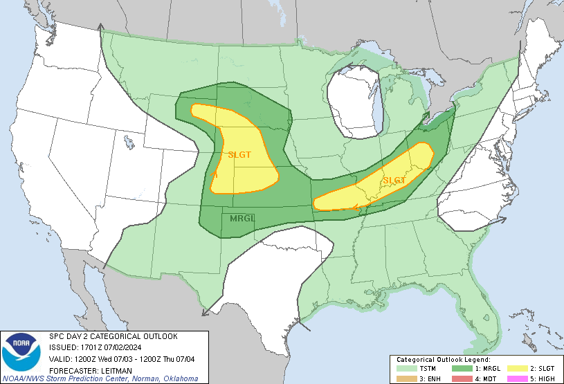
The story of these past few days shall continue as our active pattern continues and should continue for at least the next week. Under our current regime of low-high-low, chances for severe weather across the Rockies into the Midwest look likely while the Northeast looks to be on the receiving end of decent rainfall. Air quality continues to be an issue across large swaths of the Midwest. Later, a pattern breaks down to a ridge out west trough our east looks to take shape across the US leading to summer like highs out West and storms out East. Let’s take a deeper dive into this set up below!

Severe Weather from the Rockies to the Midwest
Our ring of fire set up continues to promote severe weather across the country today as damaging winds and hail look likely in Illinois into Kentucky while the chance for some tornados builds in the High Plains. These storms are forming as a result of embedded shortwaves within the Westerly flow environment present at the edges of the ridge. These shortwaves should work to provide lift across the region that is characterized by broad instability and decent shear. The largest hazard across the region will be damaging wind gusts and large hail with a heighten tornado threat across Central Illinois across Southern Indiana into Kentucky.
This region may experience multiple rounds of severe weather with a round first happening in morning due to left over storms from the previous day that should remain ongoing. The atmosphere behind these storms will still be unstable and a second round of supercellular storms capable of all hazards. Have several different methods of receiving warnings if in this region as you may find yourself under the gun several times during the day!
Out near the Rockies, storms are largely expected to form across Wyoming producing large hail and severe winds. These storms should form in the afternoon hours and persist for several hours given the moisture regime and shear aloft preventing them from collapsing on themselves. These storms should move into Western Kansas and Nebraska as the night goes on with damaging outflow winds also being a hazard.

Heat Across the South and West
Scorching temperatures are still expected across large sections of the South as dangerous heat continues to build across the region with little relief this next week. Heat is expected to continue to be in the upper 90s to mid 100s with heat indices ranging from 105 to 120 degrees. These conditions should continue until a pattern flip next week allows for troughing to be in placing across the region allowing for more rain and cooler temperatures.
When that pattern flip happens, the heat won’t be gone across the US, but instead will be present across the West. The West US is the next region expected to experience summer like temperatures which they are no strangers to. With a ridge over the region, California, Oregon, and Washington will see their temperatures climb into the upper 90s and even low 100s so those out West should start planning for some hot days in the coming future!
Rainfall Across the Northeast
The Northeast is set to see some decent rainfall over the coming days as several low pressures traverse the region. This rainfall will be largely beneficial as much of the region suffers from ongoing drought conditions. There is a chance for some isolated flooding across the region if too much rainfall falls in one place so travelers should remain mindful of the weather conditions as they travel across the region. This looks to be a particular issue at some of higher terrain spots across the Catskills and other appalachian mountains across the region.

Air Quality Continues to be poor Across the Midwest
As Canadian wild fires continue to rage, smoke continues to travel across the Midwest making air quality across the region exceptionally poor. The smoke is able to spread across the region due to our upper air pattern transporting the smoke into the area. Those within the region should take extra care to protect their lungs by limiting outdoor activities, wearing a mask, and taking breaks inside buildings with filtered air.
Travel Impacts
Those traveling across the South and West will need to continue to be mindful of the heat as they travel and work outdoors. Those from the Rockies into the Midwest should remain mindful of storms and have multiple warning methods for the potential several rounds of storms expected. Those in the Midwest should also limit their time outdoors due to harmful air as a result of wildfire smoke from Canada. Finally, those in the Northeast should remain aware of heavy rainfall and flooding that may present a problem while traveling.
Extend Outlook
The latter half of the week and early next week will see a pattern flip over most of the country. High pressure will make its presence felt across the Southern, Central, and Western US, bringing above average temperatures for many. In the Midwest, more chances for severe thunderstorms may arise heading into the weekend. The Northeast does not look to get a break from the rain anytime soon, as several surface low-pressure systems move through one after another, bringing repeated rainfall chances over the next week. The pattern flip will also work to keep wildfire smoke out of the Midwest which should improve air quality.
Conclusion
Severe weather chances exist from the Rockies to the Midwest with all hazards possible across multiple rounds. Dangerous heat continues in the South making outdoor work and travel hazardous. Rainfall looks to continue across the Northeast which should address some of the drought conditions in the short term. Isolated flooding across the Northeast cannot be ruled out in areas that are impacted by training showers and thunderstorms. Air quality across the Midwest will continue to be hazardous in the short term. Have multiple warning methods if traveling across the regions and continue to check back for updates daily!

