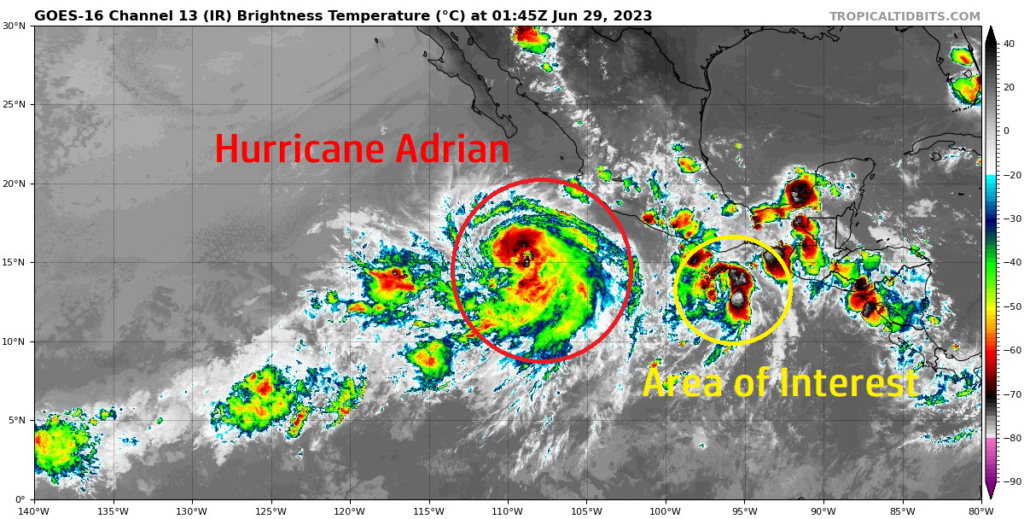
The eastern Pacific Ocean has really been getting into the act lately during this year’s early hurricane season. Currently, we have Hurricane Adrian southwest of the central Mexican coast, making its way off to the northwest into open waters. Right behind it, there is another broad area of thunderstorms associated with a surface low with a very likely chance at becoming organized in the next few days. Skipping over to the Atlantic, not a lot of notable activity is currently occurring out here. The remnants of Cindy will continue to disassociate itself over the coming days, and another grouping of showers and storms off to its east will have a hard time trying to come together with the current atmospheric conditions in place.
[wpcode id=”41149″]
Current Tropical Conditions
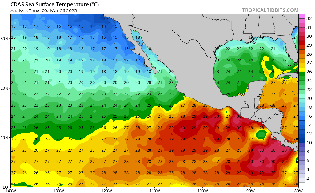
The main story here today lies in the Eastern Pacific with Adrian, as well as another disturbance off to its west with a high chance of becoming organized. Starting with Hurricane Adrian, it is currently located just off the central Mexican coast, moving off to the west into open waters at 9 mph. Still roaming over very warm SSTs and fairly weak winds aloft. As mentioned, this storm is expected to remain over open waters while it slowly makes its way westward. Current model guidance is keeping Adrian as a hurricane, but intensification to a major hurricane is always never out of the question.

Behind Adrian to its east, there is another disturbance off the Mexican coast with a high chance of development. This cluster of thunderstorms is expected to become funny organized in the wake of very warm SSTs and weak wind shear ahead. Like Adrian, it is slowly making its way off to the north-northwest, paralleling the Mexican coast. Details regarding potential intensity are a little bit cloudy at this time, but more information will be made clear in the coming days.
Over in the Atlantic, not much of note is happening over here at this time. Southeast of Bermuda, close to the remnants of Cindy, there is a region of agitated weather that will try to attempt to get its act together over the coming days but will struggle greatly to do so. Upper-air wind shear is currently pretty strong right over this area and will provide a tall task for these storms to get their act together. As always sudden changes are possible in the span of 24 hours, but right now, it does not look like development into an organized tropical cyclone is likely.
[wpcode id=”41149″]
Extended Outlook
Both systems out in the Eastern Pacific look to stay over open waters for their entire life cycles. Both the GEFS and EPS ensembles keep trying to develop low pressure disturbances on the southwest side of Mexico and moving them out into the Eastern Pacific basin where oceanic and atmospheric conditions would be favorable for tropical development over the next couple weeks. SSTs in the upper 20s to low 30 degree Celsius and minimal wind shear over this region could foster development, but no significant signal for organized storms have yet been shown. Given the conditions in play, it would not surprise me if something does form up in the long term. Out in the Atlantic, conditions will remain pretty unfavorable for tropical cyclones. Moderate to strong wind shear will make development extremely difficult for anything trying to move off the west coast of Africa, as well as down in the Caribbean Sea. Of all the basins, this one looks to be the quietest for now.
[wpcode id=”41149″]
Conclusion
The Eastern Pacific Ocean will be stealing the show for a while as far as tropical systems go. Currently you have Hurricane Adrian southwest of Mexico, as well as another surface low behind it trying to get itself organized. Both of these systems look to remain over open waters and not threaten anyone, outside of passing cargo ships in the area. In the Atlantic, hostile conditions will keep tropical activity suppressed for now, or at the very least extremely difficult to get together. One area of storms southeast of Bermuda is trying to organize itself, but strong wind shear will try to tear it apart and keep it from developing. These conditions look to last over the next couple of weeks, so currently as it stands, any chance at future development would have its best shot in the Pacific, rather than the Atlantic.


