It’s hot down in the Southern Gulf region as July is just around the corner. We are seeing temperatures above normal for the rest of the week into the weekend. Looking at our feels like temperatures for today most will be well above 100 degrees by midday today so be careful. We have a ridge brining in these abnormal temperatures for the next few days but as it dissipates early next week we will see some more on average temperatures.
[wpcode id=”41149″]
Heat! But for how long?
It’s hot and only getting hotter as we get deeper into summer. As we see in the 850mb temperature anomaly our temperatures are a few degrees above normal for this time of year. These above normal temperatures will last into next week. The heat is due to a few weather patterns in the area.
The biggest player into the heat is the ridge that is sitting over the area over the weekend. The ridge is sitting over Texas so the hot and dry air is pushing into our area. Dry air plays a big factor in seeing very high, highs throughout the day especially when the sun is right after peak. This also means we will see greater changes in temperatures and drastic cooling at night which can be a great relief. Dry air also means less chances of severe weather. This pattern will last throughout the weekend into next week as it moves over our area more until it dissipates late next week.
[wpcode id=”41149″]
Scattered Showers
The next few days are looking clear for our area. Scattered showers especially along the coastal regions are possible. Starting tonight areas such as Hattiesburg, Gulfport, and Slidell will see some rain with some areas experiencing thunderstorms. Over the weekend storms are possible but very scattered.
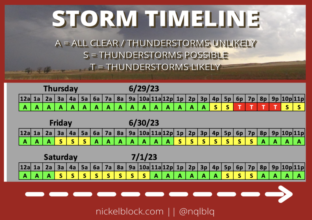
Looking over the weekend we can see those scattered showers stick close to the Gulf of Mexico. There is a slight chance of isolated thunderstorms but most of the system will be scattered showers.
[wpcode id=”41149″]
July 4th Lookout
This weekend is the main weekend for Independence Day parties due to the holiday falling on a Tuesday this year. Temperatures will be hot which is always great if you have a pool! We see some rain chances for Saturday and Sunday so be mindful if you plan on having parties outdoors. As we head into Monday we see some spotty showers in the afternoon. July 4th looks like we could be seeing some showers during the day but it looks like a high chance of rain during fireworks time. This will definitely be something to monitor as we get closer and let’s hope for no showers only sparklers!
Extended Outlook
Looking at late next week, we will see some cooler temperatures move into the area due to our ridge leaving and a cooler trough extending south over our region. However this trough will bring in stormy weather once again so enjoy the sun while it lasts. This pattern is common in El Niño seasons where we see wet and cool summers. The possibility for rain late next week into mid July is very high but that is something to watch as we get closer. For now just be cautious with the hot temperatures and sunshine.
[wpcode id=”41149″]
REGIONAL DAY-TO-DAY FORECAST
Today: Sunny. High temperatures in the upper 90s to low 100s. Winds southwest around 5 mph.
Tonight: Mostly clear. Low temperatures in the mid to high 70s. Winds southwest around 5 mph. Chance of rain 20%.
Friday: Sunny. Chance of showers and thunderstorms in the afternoon. High temperatures in the upper 90s to low 100s. Winds southwest around 5 mph. Chance of rain 20%.
Friday Night: Mostly clear. Low temperatures in the mid to high 70s. Winds southwest around 5 mph. Chance of rain 10%.
Saturday: Sunny. Chance of showers and thunderstorms in the afternoon. High temperatures in the mid to upper 90s. Winds west, southwest around 5 mph. Chance of rain 10%.
Saturday Night: Mostly clear. Low temperatures in the mid to high 70s. Winds south, southwest around 5 mph. Chance of rain 10%.
Sunday: Mostly sunny. Chance of showers and thunderstorms in the afternoon. High temperatures in the mid to upper 90s. Winds west, southwest around 5 mph. Chance of rain 20%.
Sunday Night: Mostly cloudy. Low temperatures in the mid to upper 70s. Winds south around 5 mph. Chance of rain 20%.
Monday: Partly sunny. Chance of showers and thunderstorms in the afternoon. High temperatures in the low to mid 90s. Winds south 5 to 10 mph. Chance of rain 40%.
Monday Night: Mostly cloudy. Chance of showers and thunderstorms. Low temperatures in the low to mid 70s. Winds south 5 to 10 mph. Chance of rain 40%.
Tuesday: Partly sunny. Chance of showers and thunderstorms. High temperatures in the low to mid 90s. Winds south around 5 mph. Chance of rain 50%.
Tuesday Night: Mostly cloudy. Low temperatures in the mid 70s. Winds south 5 to 10 mph. Chance of rain 50%.
Wednesday: Partly sunny. High chance of showers and thunderstorms. High temperatures in the low to mid 90s. Winds southeast 5 to 10 mph. Chance of rain 70%.


