Today we have a lot of different things going around the US. We are watching some severe weather across much of the central US, hot weather in the south, and some more smoke for the Midwest and northeast. The main region that is clear is the west coast but they are in for some heat later next week.

[wpcode id=”41149″]
Rain Today Across Rocky’s and Midwest
A storm system from the Rocky Mountains that shifted across the Plains region overnight is pushing out into the Midwest. Much of Iowa will be seeing rain today as this system crosses over in the afternoon. This evening another system will start in the Rocky’s and move eastward towards Western Kansas, South Dakota, and Nebraska. Some of these storms will be severe producing strong winds and hail. This weather will continue overnight tonight and into tomorrow as it continues to move eastward and start to dissipate.
As that system of showers moves eastward the scattered thunderstorms will be less frequent and less severe over much of the Midwest over the weekend. Followed right behind is another low pressure system this one however will bring more severe thunderstorms overnight Saturday for much of Illinois, Indiana, and Northern Missouri. This system will move eastward Sunday and bring lots of rain to the eastern US. The northeast and east coast will see these storm systems later in the weekend and into the beginning of next week. The air in the region is very unstable with is why many rounds of storms is occurring.
[wpcode id=”41149″]
Wildfire Smoke Across Midwest and Northeast
The Canadian wildfires are still going strong which is causing a lot of the smoke and poor air quality to shift downwards towards parts of the Midwest, Ohio Valley, and Northeast. Many of the major areas that saw the smoke a few weeks ago are being effected today. The Great Lakes region will see the worst air quality today. Some of the major cities under air quality alerts are Buffalo, New York City, Philadelphia, Pittsburgh, Chicago, Indianapolis, and DC just to name a few. The smoke will extend far across the east coast even into Florida and even many parts of the Great Plains region may see some of these conditions.
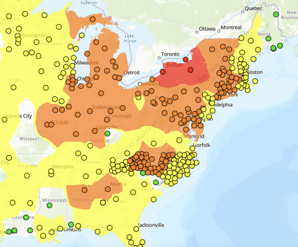
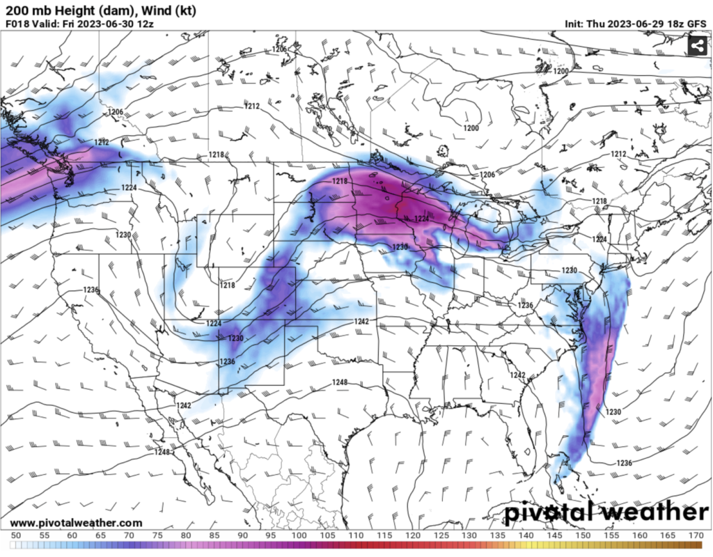
Many people are wondering why we are seeing the smoke from wildfires that are way north of their region. The main reason is due to the upper air patterns that bring much of the harsh air particles towards us. We are also seeing upper level winds pushing the smoke into our area. This causes the poor air quality to effect us. Be sure to limit your time outside especially if you live in the red and orange regions above. Be sure to keep updated as we monitor this situation.
[wpcode id=”41149″]
Heat Across Southern and Western US
It’s hot down south and it’s not stopping anytime soon. Temperatures down in the Deep South and Texas are going to be hot for the next week. Some of the heat will creep up into the Plains region today and move more eastward into tomorrow. Later next week much of the US will see warm and above normal temperatures as we kick off July. The feel like temperatures are going to be very hot as well as a high heat index in many parts of the southern US. We can see many parts of the south seeing above 90 degrees and some cities even reaching over 100 degrees so make sure your staying cool!
This pattern of hot weather is due to a ridge sitting in the southern and plains region of the US. As the ridge pushes out of the area a trough will move in bringing some cooler temperatures next week. This will be a major shift in the overall weather pattern down south as we cool down and see more storms in the area. Pushing westward on the flip side will be another ridge building across much of the west coast. Temperatures will feel more summer like for this area which is normal for this time of year.
[wpcode id=”41149″]
Travel Impacts
Across much of the Midwest and northeast traveling can be slow due to limited visibility from the smoke. The biggest thing is traveling by airplane be prepared for possible delays as you are traveling for the holiday weekend. Many major hubs will be effected by the wildfires so check for updates from your airline. If you are traveling along I-70 this weekend be prepared to run into severe weather. If you are spending your weekend down south I would suggest you make sure your vehicles have functioning AC’s because it will be hot!
Extended Outlook
We will be seeing a big shift in weather patterns across the country as we head into next week. Hot temperatures will not be going anywhere for a while but more parts of the central US will get in on the hot action. Rain is prominent across the Plains, Midwest, and east coast for much of this weekend and into next week. On the bright side much of this wildfire smoke should push itself out of the US next week which will help improve the air quality outside. Hopefully some clearer weather will be in store of the regions of rain later next week.
[wpcode id=”41149″]
Conclusion
Rain is going to be the biggest problem today and over the weekend for much of the eastern half of the US. Dangerous heat will takeover the south today and for the next few days. Canadian wildfire smoke will be a big problem today for much of the northeast and Midwest. As we get into next week rain will effect parts of the east coast. Hot weather will come to the west and hopefully some southern cooling lat next week. Be sure to keep safe especially if your in any areas with this wacky weather going on!


