
Tropical Weather Outlook
NWS National Hurricane Center Miami FL
800 PM EDT Tue Jul 9 2019For the North Atlantic…Caribbean Sea and the Gulf of Mexico:
1. A broad low pressure area located over the Florida Panhandle and the far northeastern Gulf of Mexico is producing widespread but disorganized showers and thunderstorms. Environmental conditions are conducive for development, and a tropical depression is expected to form late Wednesday or Thursday while the low moves slowly westward across the northern Gulf of Mexico. Tropical Storm, Hurricane and Storm Surge Watches could be required for a portion of the northern Gulf Coast on Wednesday. An Air Force Reserve Unit reconnaissance aircraft is scheduled to investigate the disturbance tomorrow afternoon. In addition, this disturbance has the potential to produce heavy rainfall from the Upper Texas Coast to the Florida Panhandle during the next several days, and interests in those areas should continue to monitor the progress of this system. For more information, please see products issued by your local weather forecast office and the NOAA Weather Prediction Center.
* Formation chance through 48 hours…high…90 percent.
* Formation chance through 5 days…high…90 percent.
As the overnight information trickles in, data is coming into a better consensus. The National Hurricane Center is now pretty confident that a Tropical Depression will form during the next 48 hours. The NHC has given Invest 92L a 90-percent chance of development during the next 48 hours.
Things we know even more about
Rainfall & Flooding Risk
We are getting a better idea about rainfall totals along the Gulf Coast and Southeast from this system. While nailing down how strong it will become, or the specific track are still a bit out of reach, model data continues to show impressive rain totals for parts of Louisiana and Mississippi. The Weather Prediction Center continues to show a bulls-eye of heavy rain across parts of Louisiana with higher totals for portions of Texas, Arkansas and Mississippi, too.

The WPC may be under-doing the rainfall for some areas given the latest model trends, but they tend to be a bit more conservative with rainfall forecasts at this distance in time – which is fine.
The trend within the GFS during the last few days is a reasonable increase in rainfall totals for portions of Louisiana and Mississippi.
Timeline
While things are not set in stone, we are starting to get a better idea about the timeline of events in the coming days. Here is a loose timeline of events…
Wednesday – organization while drifting Southwest
Thursday – Development & Strengthening while moving West
Friday – Strengthening while moving West
Saturday – Moving ashore while turning north
Sunday – Ashore and raining itself out
Things we are starting to get a better handle on
Forecast track
While we still don’t know a lot about it, we are starting to get a better idea. I think it is best summarized by Levi Cowan of Tropical Tidbits. He made this video tonight explaining the track of Invest 92L:
He makes a great point during the video that just because models come into consensus about an area for landfall doesn’t mean that confidence is increasing for that area for landfall. It just means that models are ‘seeing’ the same thing. That is good! But doesn’t mean the end result is any more likely. Becuase both models could be ‘seeing’ the same wrong thing.
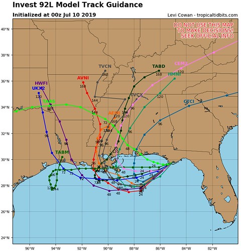
The spaghetti models highlight some fascinating differences between the models that we are still waiting to shake out. The consensus is for landfall a bit further east than shown last night, but not much. It also shows that there are no longer two different ‘batches’ of landfall points, but rather one main area and then some outliers.
Strength
Sort of. I mean, not really, but hear me out. We know that organization and strengthening are looking more likely. Twenty-four hours ago the guidance was showing strengthening, but a lot of meteorologists were wisely reserving judgement. Now we are getting a better feel for things and have more confidence that some sort of strengthening will occur.
What we are still trying to figure out
How far west
Just how far west will this thing go before it runs north? We just don;t know yet, because it is going to be dictated by the storm’s strength.
Strength
While we know more, we don’t know enough. We still need to monitor model guidance and satellite presentations to figure out just how strong this thing will get.
Caution advised using the first 18z HWRF run of #92L.
From the get go, convective features are off. Its 6h forecast has little to no convection over land & a developing MCS offshore. It is almost the inverse of the current IR satellite w/ almost all convection onshore. pic.twitter.com/4nhuzLhvMP
— Philippe Papin (@pppapin) July 10, 2019
The models aren’t doing a great job with this yet, either.
Storm Surge
This, too, will be a function of the storm’s strength. Until we know that, we won’t know this.
What should you do now?
If you live in a flood-prone area, assess your surroundings. Is the creek near your house clear of debris? Are the storm drains clogged? Fix those things now. If a Flash Flood Emergency was issued for your area, do you know where to go? Find a safe place from flooding now.
While this isn’t anticipated to be some Monster Hurricane, prolonged rain can cause serious problems. Flooding is the deadliest form of severe weather. It kills more people than tornadoes. So please take it seriously.
Also check your Hurricane Preparedness Kit. That’s about it. Make sure you have enough supplies to last a few days without power and water. Not because this system is anticipated to wipe out power and water to an area, but rather, you should always have enough supplies to last a few days without power and water during Hurricane season.


