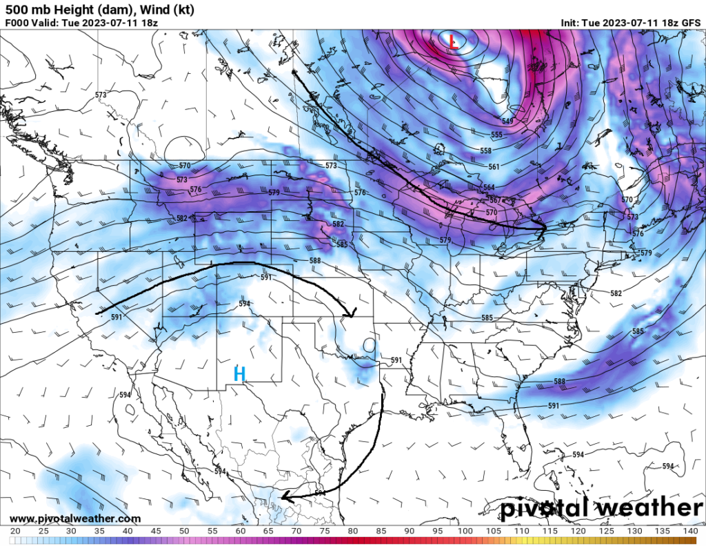
Quite a difference can be found in the various forms of weather from west to east across the country, as we continue the pattern of high pressure in the west and low pressure in the east. As a result, we will continue to see the heat rise and spread out in the west and persistent scattered rain chances in the east. Eventually though, the high pressure out in the west will win out and intensify across most of the western and southern US, spreading the heat further east and really causing heat-related illness concerns in these regions.
The West Bakes
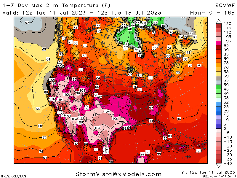
It’s already very hot out in the western US, and it only looks to keep getting hotter and more widespread as the rest of the week progresses and into next week. High pressure in the mid-levels responsible for the triple digit heat across the Desert Southwest will keep building day by day for the foreseeable future. Temperatures out here and extending further east into Texas will stay above 100 degrees in the near-term, especially as the center of this high pressure migrates slightly back west. The heat will still pose a risk for heat-related illnesses in the near-term period for those outdoors and will continue to cause issues over the next 7 days. Extreme caution should be taken when doing rigorous activities outdoors and be sure to have multiple different ways to beat the heat.
Scattered showers and thunderstorms in the Central US
Northwest flow aloft has helped to bring numerous, almost daily rounds of showers and thunderstorms to many across the central US. Some of these storms, however, will carry a severe threat specifically today and tomorrow for many in the central third of the country. The most likely day to see severe thunderstorms at this moment will be today across portions of Kansas, Nebraska, Missouri, Iowa, Illinois, and Indiana. Possibly numerous clusters of thunderstorms look to form in the afternoon/evening hours in Nebraska and Iowa and propagate southeast throughout the evening and overnight hours. Strong wind shear and instability will favor a supercellular mode early, with very large hail and damaging winds being the main concerns before transitioning to an MCS-type mode with damaging winds being the primary concern. Past today, more scattered showers and thunderstorms will be possible virtually every day through the week and weekend as this northwest flow stays parked aloft and keeps providing the means for the development of storms.
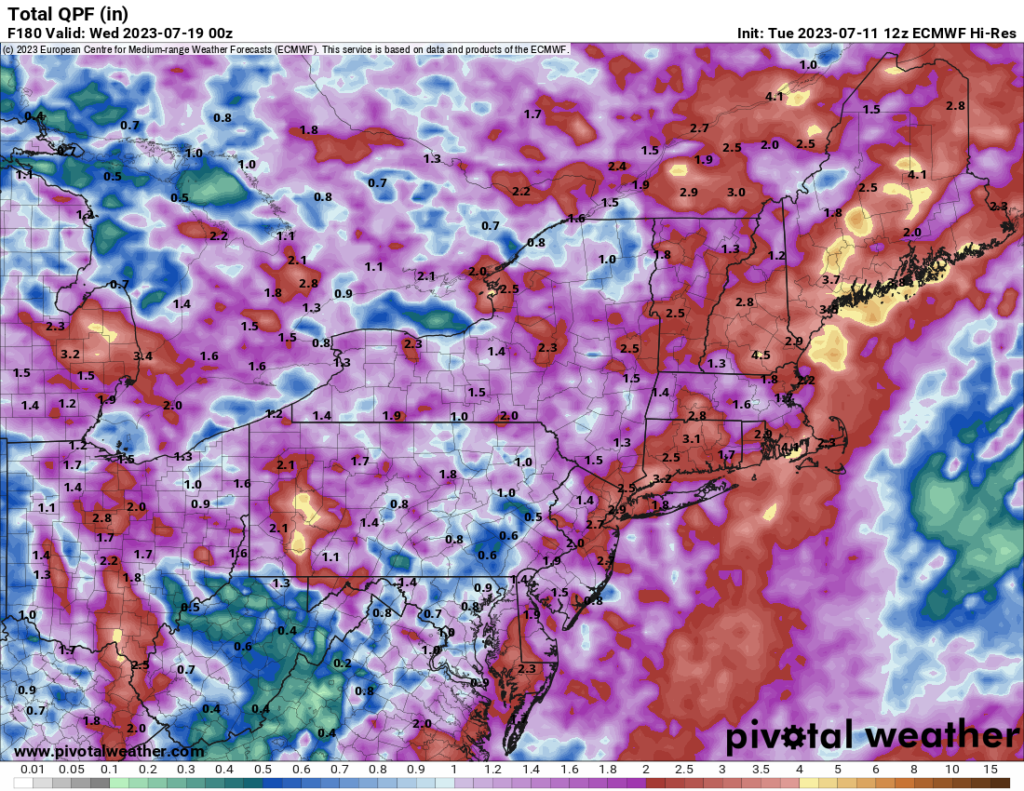
Very wet in the Northeast
Rain, rain, and more rain. That has been the common denominator up here for days now and will continue to be so over the next week. Westerly flow with embedded disturbances in the flow will help trigger scattered to numerous showers and thunderstorms across much of the northeast. Rich moisture and moderate to high Precipitable Water values (1.25″ to 1.75″) will promote efficient rainfall with these showers and thunderstorms and will continue to pose a flooding concern. Areas in the far Northeast may end up seeing an additional 2 to 4 inches of rainfall over the next week, with locally higher amounts a possibility.
Extended Outlook
The main story in the long-term period will be the intensifying dome of high pressure over the western US. By this weekend and into next week, there is some indications that the 500mb height may reach a very anomalous peak of 6000m (!) and spread out further north and east to virtually cover half of the country. Temperatures near or above 100 degrees will be common from the southern Plains to California and up as far north as possibly western Washington. Out in the Desert Southwest to central California, temperatures will go even higher to possibly the 115-120 degree range, with the chance for areas such as Death Valley to go even higher. This trend will have to be watched carefully as the end of the week approaches and precautions should be taken if at all possible to beat the heat.
Travel Outlook
Delays at airports in the eastern 2/3 of the country due to showers and thunderstorms may occur over the next week, as several places will see substantial opportunities for precipitation. Dangerous travel conditions in the northwest may exist with repeated rounds of showers and thunderstorms in the region. These storms may bring flood conditions to the area over the coming days especially with the abundance of moisture in the air available for these storms to utilize. Otherwise, heat will be the other noticeable concern in the western US over the next 7 days and safe travel measures to avoid heat impacts should be taken in this region of the country.
Conclusion
Most of the attention in the short and long-term will be on the progress and intensity of this high-pressure system in the western US, bringing very substantial heat to the region. Moving further east, showers and thunderstorms, some possibly severe, look to make an appearance virtually daily in the central and eastern US. Some of these rains, especially in the Northeast US, may bring several inches of rain over the next week and harbor a flood risk for some. By later in the week and early next week, the aforementioned high-pressure will have most of the western US under its firm grasp and very hot, dangerous temperatures will likely present themselves for millions of people across the western half of the country.


