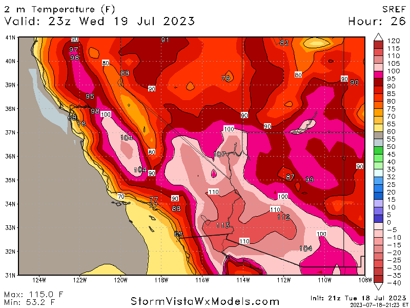
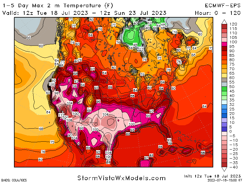
The next seven days will see largely the same unsettled weather conditions across the country, with broiling temperatures across the desert Southwest and continued scattered thunderstorm chances in the Plains and Eastern US. A rather potent area of high pressure located over the southwestern US has been hovering over the region for a while now, which had helped Furnace Creek in Death Valley reach 125.6°F this past weekend, will continue to hang around the region and keep temperatures well north of 100° for many.
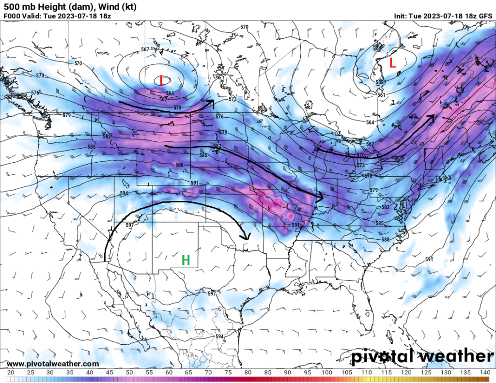
For the eastern two-thirds of the country, strong mid-level troughing will keep thunderstorm chances hanging around for many, as well as sparing most people from the (relatively) high temperatures as experienced out west. All of this looks to change though by early next week, as the dome of high pressure out west begins to migrate eastward towards the middle part of the country and allow for temperatures to start climbing.
[wpcode id=”41149″]
Broiling heat persists in the West, as well as a chance for storms
The same song and dance out here will be sung once again, as is per usual this time of the year. This rather potent high-pressure dome looks to just sit over the region over the next 7 days. Daily high temperatures across the Desert Southwest and into central California will stay well north of 100°F, with some areas potentially staying around the 110°F-120°F for several days. Heat Advisories and Excessive Heat Warnings will remain in effect for several places all the way till Friday and Saturday.
Isolated thunderstorms will be possible over the next few days, mainly in higher elevations across Arizona and New Mexico, with some of these storms possibly being severe across portions of northeastern New Mexico. The best chance for any severe thunderstorms will be on Thursday evening, as an MCS originating from Colorado will move southeast across the area from 6pm-12am. Strong instability, strong wind shear, and high amounts of DCAPE (around 900-1200 J/kg) will allow these storms to be capable of all hazards, with damaging winds being the primary concern.
[wpcode id=”41149″]
Average temperatures and scattered storms in the Plains
The Great Plains, from North Dakota to Kansas, with remain mostly average to somewhat below average temperature-wise until early next week, with the continued influence of a low-pressure system off in Canada that has allowed a belt of moderate northwesterly flow aloft to sit over the region. This flow, with embedded shortwaves and disturbances within the flow, has helped blow in scattered thunderstorms throughout the region, with some of these storms being severe. This trend looks to continue over the next 5-7 days.
Severe thunderstorms will be possible today and tomorrow as a cold front comes through from the north and interacts with a moist and unstable airmass draped over the area. For today, those with best odds at seeing severe thunderstorms will be those in portions of northern Kansas, Nebraska, western Iowa, southern Minnesota, and western Wisconsin. Supercells will be favored in wake of strong deep-layer shear and modest instability, with large to very large hail and damaging winds being the primary concerns, although a tornado or two cannot be ruled out either.
Development of these storms appears to be around the 6pm time frame and lasting all the way till around midnight or so.
Tomorrow, the severe threat shifts south into Kansas and Colorado. Supercells will again be favored early, being capable of large hail and damaging winds, before transitioning to a more multicellular/MCS-type mode, where damaging winds will be the main concern. Timing on these storms will see development in Colorado around 4-6pm MDT before moving southeast during the overnight hours.
[wpcode id=”41149″]
Several opportunities for rain in the Eastern US
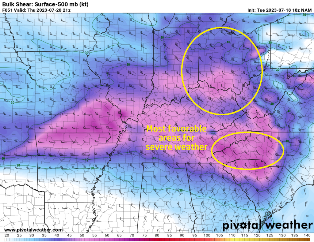
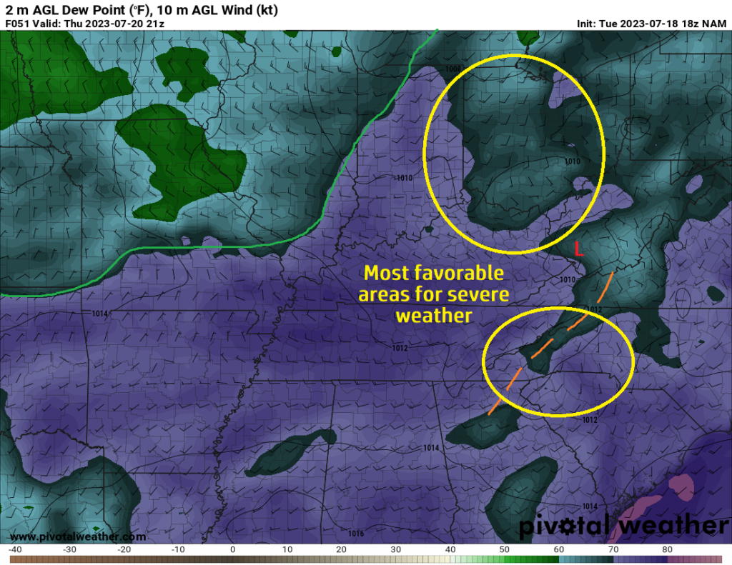
Staying with the wet theme out here, additional scattered to numerous rain showers will be possible for many across the Eastern US. Rich Gulf moisture being fed into the region will help fuel the development of showers and thunderstorms across this section of the country over the next 7 days. In the short-term, severe thunderstorms may be possible for portions of the Ohio River Valley, such as Ohio, Indiana, and Kentucky, on Thursday. In front of an incoming cold front, deep moisture from the Gulf will interact with any existing outflow boundaries from leftover showers and thunderstorms and aid in the development of storms.
Shear profiles will favor at least a multicellular to perhaps supercellular storm mode, with hail and damaging winds being the primary issues. These storms will move southeast throughout the evening and overnight hours. Additionally, more severe thunderstorms may be possible across the Carolinas as well during the afternoon and evening hours from deep moisture interacting with a surface boundary present in the area. Damaging winds will be the main concern with the strongest of these storms.
After these severe thunderstorms, numerous showers and thunderstorms will continue to be possible into the weekend across the Eastern US as this low-pressure system and associated cold front passes through. Widespread rain totals for the eastern third of the country will amount to 1-2 inches over the next 5 days, with the potential of locally higher amounts possible with more intense thunderstorms.
[wpcode id=”41149″]
Extended Outlook
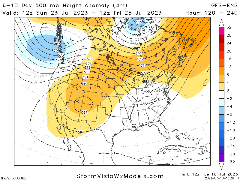
High pressure will begin to strengthen and advance eastward over the southern and central Plains by early next week, displacing the low-pressure system off to the east and pushing substantial rain chances towards the northern US. As a result, temperatures will begin to climb as the pressure builds, with more widespread 90° and possibly 100° temperatures found up and down the Great Plains and into the Southeast through next week.
[wpcode id=”41149″]
Travel Outlook
Main travel concerns will be in any areas where severe thunderstorms may be possible across the eastern half of the country over the next few days. Expect some airport delays from heavy thunderstorms and consider alternate routes to avoid these areas if at all possible. If you have to drive through these areas where severe storms are possible, keep tabs on any new updates from news outlets or the National Weather Service and have multiple ways of receiving weather information. Otherwise, mind the heat when driving through the southwest and be sure your air conditioning works in your vehicle to protect yourself from the very high air temperatures.
[wpcode id=”41149″]
Conclusion
Quite an active pattern of weather will be in place across the contiguous US through the end of the week and into early next week, with heat in the southwest and scattered showers and thunderstorms in the eastern half of the country, with some of these storms being possibly severe. This all will preclude a pattern change aloft, as we will see a much greater influence from high pressure spreading over the central and southern US by next week, which will increase temperatures and decrease rainfall chances. For many, this week may be the last week of relative comfort, in summer terms, before we feel the heat next week.


