Check out the video forecast!
[wpcode id=”41149″]
Hot temperatures will continue over the weekend. The potential for storms is high for Saturday and Sunday which some possible severe thunderstorms. This rain will bring some cooler temperatures early next week that may not last very long. Let’s get into it!
[wpcode id=”41149″]
Heat Coming on Down
Today into the weekend we will see very hot temperatures across the area which temperatures in the upper 90s which some highs reaching over 100. With storms coming through in the weekend it will help cool down the highs slightly. High will be in the upper 80s, low to mid 90s which is cooler than they were. The one factor is it will still feel very hot due to high humidity and moist air. The heat indexes will be very high so the temperature will feel like it’s 100. Stay hydrated when you are working outside and be sure to take breaks indoors with AC to avoid heat related illnesses.
Heat advisory’s are in effect for today and Friday for much of our forecasted region. Much of our area will be under significant or elevated heat risk which means it will be very dangerous outdoors.
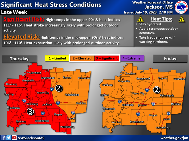
Jackson MS Heat Risk 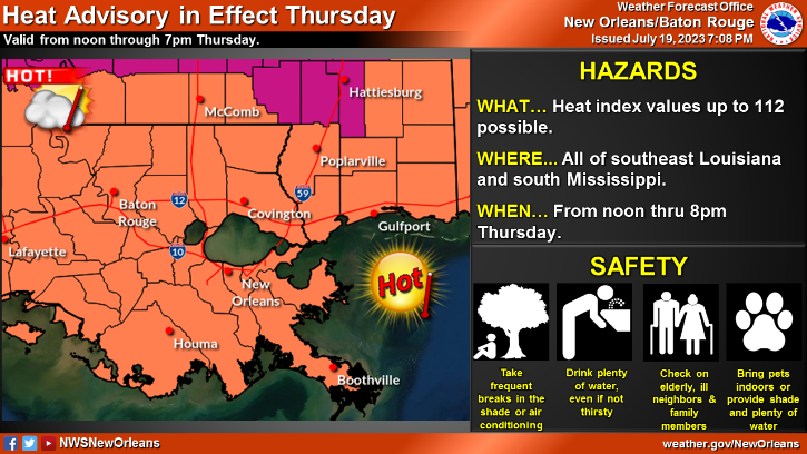
Baton Rouge LA Heat Warnings
[wpcode id=”41149″]
Weekend Showers
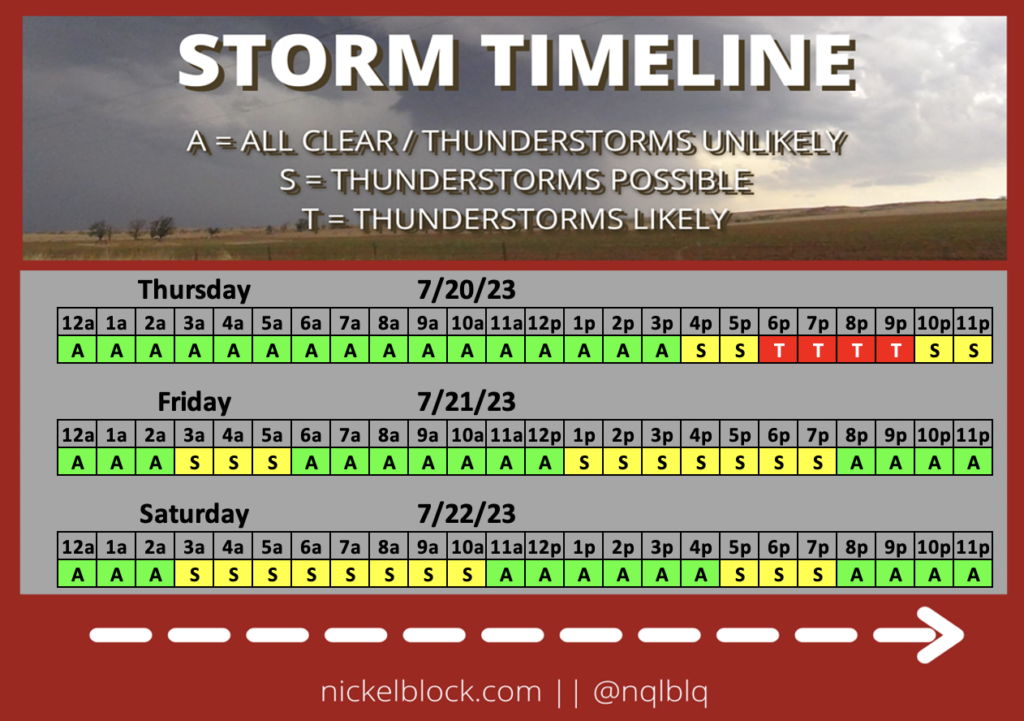
This weekend we will see some showers scattered throughout the area. Saturday some scattered rain showers especially in the northern part of Mississippi. Saturday night into Sunday we will see showers across our area which possible thunderstorms in some areas. Sunday rain will scattered throughout the coast. Sunday evening we will see the best chance of severe weather which thunderstorms in the area. Rain showers will follow overnight and clear out early Monday morning. Next week scattered showers will be in the area with possible afternoon thunderstorms.
[wpcode id=”41149″]
Extended Outlook
Looking ahead we see this hot weather pattern remain in the south and across much of the US. Temperatures will be more normal but will be cooler than this week due to some troughing in the area. After the trough moves a ridging pattern will sweep in the area bringing back the above normal temperatures to the region. Moist air will remain stable which is why we will see some scattered showers throughout the next week. However, after this week we will see some drier weather. With the hotter temperatures and drier air it will feel very hot so always be cautious.
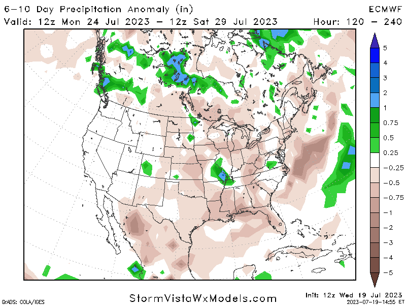
Projected Total Rainfall 6-10 Day Outlook 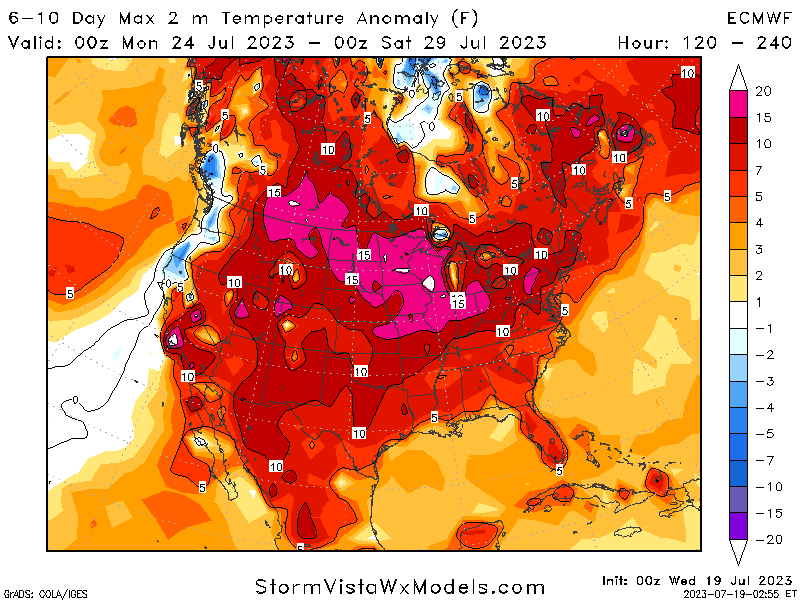
Projected Temperature Anomaly 6-10 Day Outlook
[wpcode id=”41149″]
Regional Day-To-Day Forecast
Today: Sunny. High temperatures in the mid to upper 90s. Winds west southwest around 5 mph.
Tonight: Mostly clear. Low temperatures in the upper 70s to low 80s. Winds south around 5 mph.
Friday: Sunny. Chance of showers and thunderstorms. High temperatures in the mid to upper 90s. Winds west around 5 mph. Chance of rain 20%.
Friday Night: Partly cloudy. Chance of showers and thunderstorms. Low temperatures in the upper 70s to low 80s. Winds southwest around 5 mph. Chance of rain 20%.
Saturday: Mostly sunny. Chance of showers and thunderstorms in the afternoon. High temperatures in the mid to upper 90s. Winds west around 5 mph. Chance of rain 70%.
Saturday Night: Mostly cloudy. Chance of showers and thunderstorms. Low temperatures in the low to mid 70s. Winds east northeast around 5 mph. Chance of rain 70%.
Sunday: Mostly sunny. Chance of showers and thunderstorms in the afternoon. High temperatures in the low to mid 90s. Winds northeast around 5 mph. Chance of rain 70%.
Sunday Night: Partly cloudy. Chance of showers and thunderstorms. Low temperatures in the low to mid 70s. Winds south 5 to 10 mph. Chance of rain 50%.
Monday: Sunny. Chance of showers and thunderstorms. High temperatures in the low to mid 90s. Winds northwest 5 to 10 mph. Chance of rain 50%.
Monday Night: Partly cloudy. Chance of showers and thunderstorms. Low temperatures in the low to mid 70s. Winds south 5 to 10 mph. Chance of rain 50%.
Tuesday: Sunny. Chance of showers and thunderstorms. High temperatures in the low to mid 90s. Winds southwest 5 to 10 mph. Chance of rain 50%.
Tuesday Night: Partly cloudy. Low temperatures in the upper 70s to low 80s. Winds southwest 5 to 10 mph.
Wednesday: Sunny. High temperatures in the mid to upper 90s. Winds southwest 5 to 10 mph. Chance of rain 10%.


