Unsettled weather is the story for the next seven days as heat continues to build over the West and a stormy pattern continues in the East. This pattern is a direct result of the ridging currently out West as a High Pressure sits overtop the four corners region of the US while troughing due to an upper low over Hudson Bay leads to enhanced storm development.

[wpcode id=”41149″]
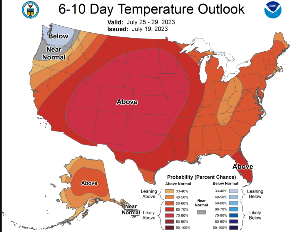
Heat Builds Across the West
Heat continues to build as a High pressure ridge sits atop the Western US. This high, acting as a dome, is working to keep hot dry air trapped near the surface both during the day and during the night time hours. With this set up there is little, if any, relief expected for our friends in the West. If there is a chance for relief, it can be found within the higher elevations of Arizona and New Mexico where we may see some isolated thunderstorms develop. The local environments of these storms will need to be monitored as if a dry layer is present within the environment, dry microbursts and thunderstorms could work to elevate fire concerns more so then provide relief from the heat. Areas which see no relief are mostly covered with heat advisories and warnings at this time showing the threat for heat indices in the 105 to 115 range. Anyone working outdoors should continue to remain hydrated and take breaks as needed!

MCS Season Continues in the Plains
An MCS is once again expected to take shape across SE Colorado as a cold front that is draped across Colorado becomes the focus for storm development. This front, should initiate storms across the area in the form of clusters. These clusters will have an initial damaging wind and hail threat with an isolate tornado possible. These storms will begin to initiate and grow upscale into the evening hours where they will begin to move Southeastward and bring the threat for damaging winds and hail to parts of Kansas and Oklahoma. Listen to all severe warnings when issued and remain weather aware if in the path of this MCS.
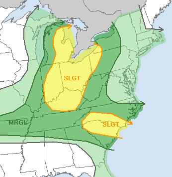
Storms Across the East
Storm chances continue across the Eastern US as troughing helps promote a general unstable pattern. Scattered showers and thunderstorms are expected in several different locations with the best chance for severe storms being Michigan, Ohio, Kentucky, Indiana, Pennsylvania, New York, South Carolina, and North Carolina. The main threats for these areas will be damaging winds and hail, but an isolated tornado cannot be ruled out. This general stormy pattern in the East should follow the diurnal cycle with a peak being in the late afternoon to early evening hours and a quiet overnight period.
Extended Outlook
Ridging is expected to expand across CONUS leading to widespread heat and reduced storm chances. In areas where heat has already been a concern, fire conditions may become worse as those areas have already dried out much faster then regions which have been receiving plenty of rain. Regions which have been spared the worst of the heat this summer should prepare for potential dangerous heat conditions and make sure to take plenty of breaks and remain hydrated!
[wpcode id=”41149″]
Travel Outlook
If you are traveling across the Plains or in the Eastern US, use caution as severe storms with damaging winds and hail may disrupt travel plains. Flight delays and flooded roadways would not be uncommon during this time period. Otherwise, mind the heat when driving through the southwest and be sure your air conditioning works in your vehicle to protect yourself from the very high air temperatures.
[wpcode id=”41149″]
Conclusion
Heat continues to be the main story with the ever present ridge continuing to stay put. Scattered showers and thunderstorms could continue to be a problem across the Plains and East before the ridge builds in and introduces more heat into an already warm environment. Hopefully, you all are staying nice and cool this summer in an effort to avoid this heat!


