Hot weather kicks in the US this week and into next week as we see most of the country above normal for temperatures. Big ridging across the west will bring super hot highs this weekend. A smaller trough out east alongside some rain will keep it cool out there on the opposite side of the US. There will be some severe storms this morning and over the weekend in the eastern half of the US so let’s jump into it!
[wpcode id=”41149″]
Heat Heading Across the Country
Summer is kicking in across the entire CONUS. Highs are high especially out west this weekend. The southwest will be seeing highs in the 100s for a lot of areas. As much as this is a “dry heat” it is still HOT. This heat will stay overnight as well in most areas meaning the cool down won’t exist much. Most of California will have temperatures in the upper 90s and 100s. Even up in Washington state temperatures will be in the upper 80s to upper 90s in the less elevated regions. Many parts of the southern US even the southeast will have highs today close to or above 100 degrees. This heat will continue over the weekend and start to extend into the plains and midwest as we head into next week.
Next week the super hot temperatures coming from a ridge will move across to the central plains where temperatures will be well above normal. Temperatures will reach 100 degrees or more. The west will finally start to cool down especially the northwest. The southwest will still be very hot but not quite to the extent as this weekend. This ridge will continue to move east and bring in the heat to the midwest later next week. The plains will see hot temperatures so always be cautious when working outdoors in such extreme heat with high heat indexes. Watch out for excessive heat warnings for your area and follow the guidelines from the National Weather Service.
[wpcode id=”41149″]
Storms in East and Midwest
Today the folks in the central plains and upper east coast will wake up to wet weather. Kansas and Oklahoma will be facing some thunderstorms that have a likelihood of producing hail and severe winds. This storm system will move east and dissipate some within the morning hours. The midwest may see some scattered showers over the weekend but be mostly clear in this region.
Across the southeast, states like Kentucky, Tennessee, Missouri, Georgia, and Alabama will see the storm system from the plains in the afternoon. This weekend the southeast will see some scattered showers across the region will a stronger storm system moving across the Gulf coast Saturday night into Sunday. Another storm system will push through right behind Sunday night for these southern states into Monday.
The northeast will be seeing a low pressure system bring a big rain system across this morning. Coming from the Ohio valley region last night this storm system moves it’s way east northeast. Central Pennsylvania will see more thunderstorms and heavy rain but as the storm moves eastward the strength will weaken and will be mostly rain for the northeast will scattered thunderstorms. Most of the rain will be out of the area by Saturday will some storms lingering around Maine, New Hampshire, and Vermont. The rest of the weekend should be pretty clear for this area.
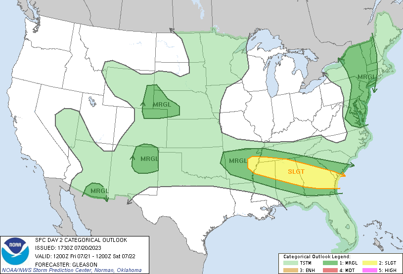
SPC Outlook for Friday 12Z to Saturday 12Z 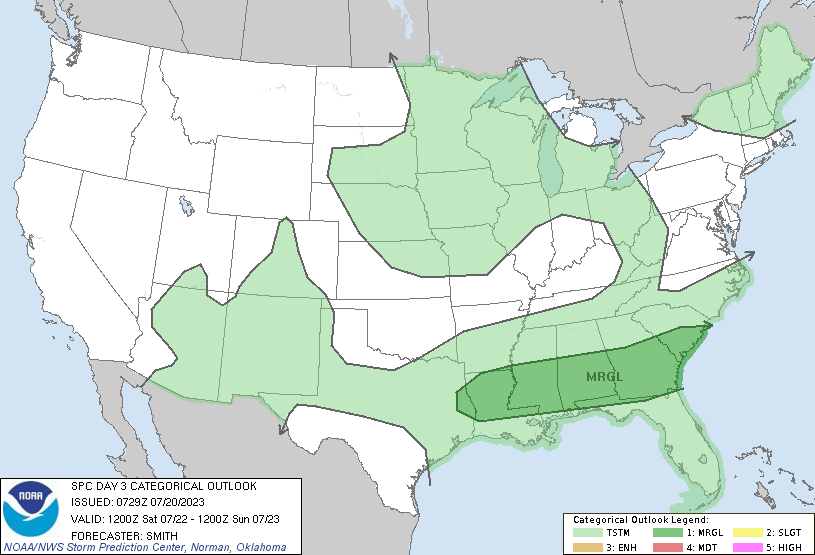
SPC Outlook for Saturday 12Z to Sunday 12Z
Looking further ahead into next week, scattered showers and thunderstorms will span across the southeast and midwest as separate storm systems. A wet pattern will continue around the eastern US this coming week as the west stays pretty dry. Most storms will start in the central plains and move their way either across the north eastward into the northeast or move southeast to the Gulf states.
[wpcode id=”41149″]
Travel Impacts
Traveling across the Midwest, Southeast, and Northeast today and over the weekend may be challenging. Many major airport hubs may be experiencing delays due to the rainfall. For your morning commute in KS or OK be prepared for severe weather. Same goes for traveling in PA in the afternoon hours. Much of the northeast will see rainfall so always be careful driving in wet conditions because of slippery roads. Always check local traffic reports before heading out and avoid unnecessary travel in severe weather conditions.
[wpcode id=”41149″]
Extended Outlook
Looking ahead after this week we will see that big pattern shift across the US that will start in the end of next week. We will see a dry pattern spread across much of the Southern and Eastern half of the US. For the northeast this will be nice compared to the consistent rain. The western half of the US will be on average for rainfall. We do see some smaller patches of above average rain in the Missouri, Illinois region as well as some other smaller areas. Most of the US will be on average or below average for precipitation. This doesn’t mean it will be perfectly clear but the odds of less rain days is greater.
As for heat we will see almost the entire CONUS region well above normal for highs. The upper plains and midwest region will be seeing the greatest amount of above average heat for the area. This means temperatures will be very hot and for that region it is more uncommon so its more crucial to avoid being outside for extended periods of time as most people there are not used to such heat. Whereas in the south temperatures will be above normal but for the south it is something most of the people are adjusted too. That doesn’t make the excess heat any less dangerous but it won’t be as big of change for the people living down there.
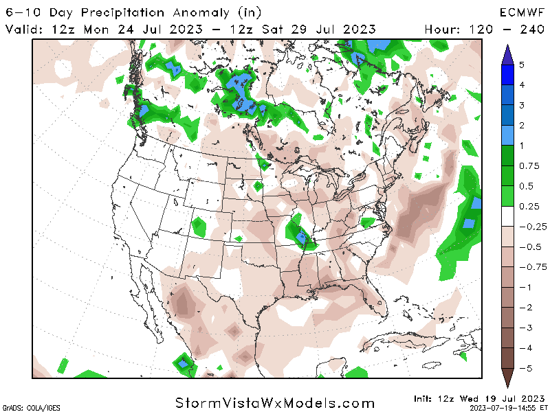
Projected Total Rainfall 6-10 Day Outlook 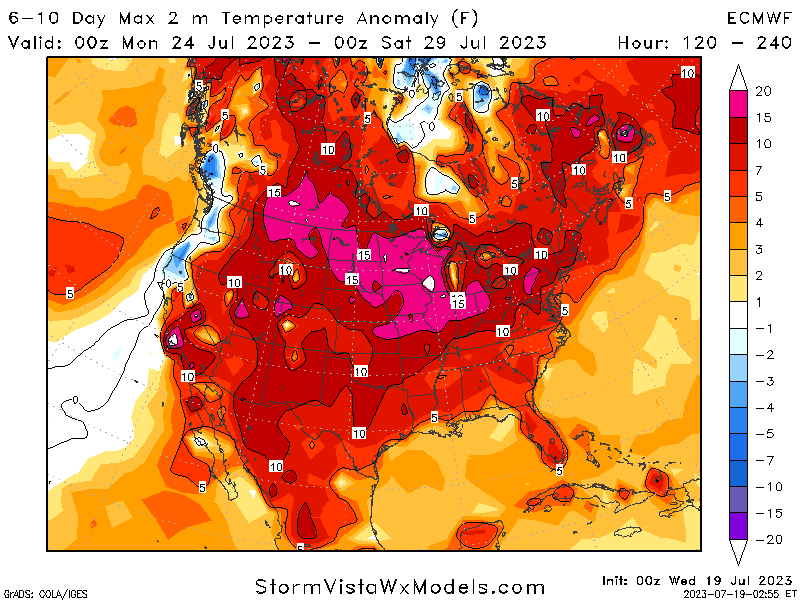
Projected Temperature Anomaly 6-10 Day Outlook
[wpcode id=”41149″]
Conclusion
The heat will be extreme this week. Starting in the west today the ridging motion will shift eastward over the weekend and give the central plains a lot of hot weather with temperatures in the 100s for many areas. This heat will continue throughout the week across much of the US. As for rainfall the central plains will see some severe storms today that will shift eastward over the weekend. The Ohio valley and northeast will also see wet weather today and over the weekend. Be sure to check your local forecast for more detailed information to stay safe!


