Many throughout the central portions of the country will experience hot to very hot temperatures over the coming days, as an anomalously strong ridge of high-pressure sets in and leaves us baking in the heat. Temperatures easily will reach into the mid to upper 90s at the very least, to possibly the upper 100s for many, especially in the southern Plains. Heat indices will also look to soar as well, possibly approaching 110°F across the south and southeast. Off towards the southwest, continued scattered showers and thunderstorms will persistently overspread the Four Corners states, where some of these storms pay pose an isolated flood threat.
[wpcode id=”41149″]
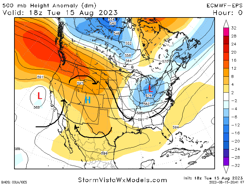
Heat on the rise in the central third of the US
One of the larger stories across the country over the coming days will be the gradually rising heat over the next 5 days. Mid-level high pressure will steadily build over the central US and may eventually strengthen to a 597-600 dam high, which will thoroughly suppress any storm development across the region and help bake the region in heat. Temperatures from the north central US down to the south and southeast US will easily reach the 90s, and the southern Plains and southeast reaching the century mark. Measures to shield yourselves from these temperatures is highly advised, including frequent breaks from outdoor activities and staying well-hydrated to fight off dehydration.
[wpcode id=”41149″]
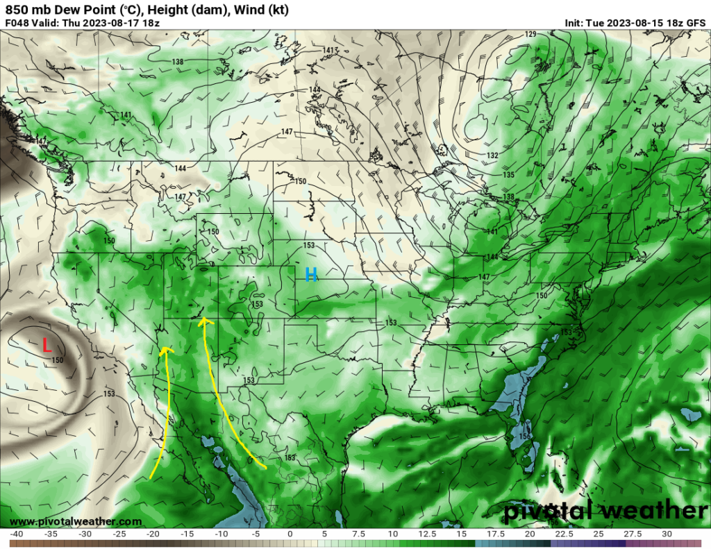
Moisture funneling into the Southwest
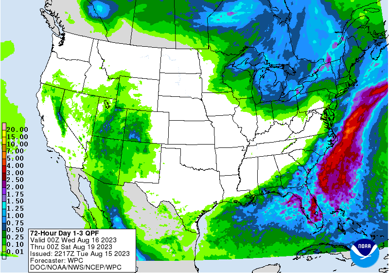
Multiple rounds of precipitation can be expected across the Four Corners region of the country over the next few days. Moisture from the Pacific Ocean and Gulf of California being drawn in by a closed low off the coast of California will continuously feed over the region where it will provide the fuel for multiple rounds of scattered showers and thunderstorms. Widespread rainfall amounts of at least half an inch will be expected with these storms, with the potential for locally higher amounts and an isolated flash flood threat being possible. Areas more prone to these flood events will be any areas with burn scars or small canyons.
[wpcode id=”41149″]
Extended Outlook
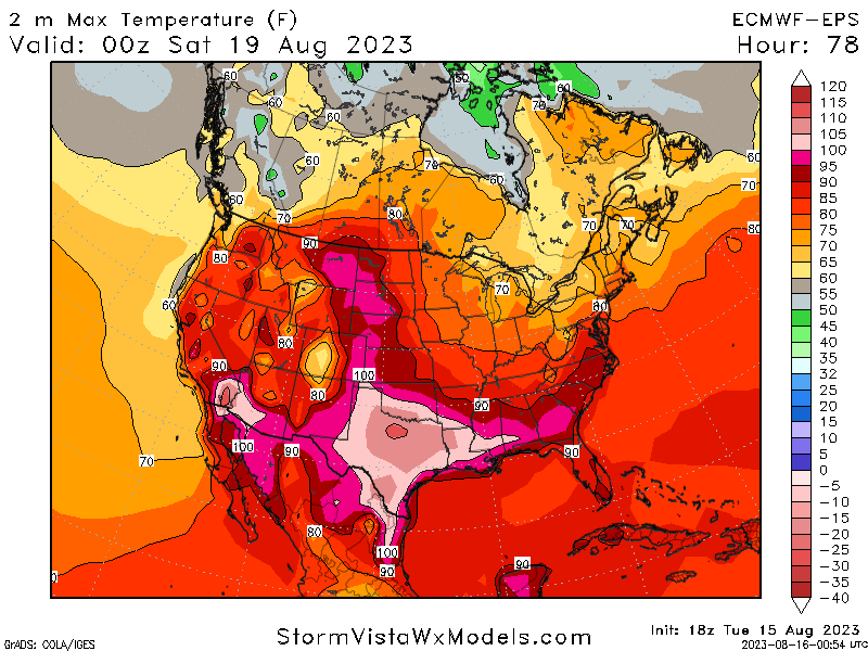
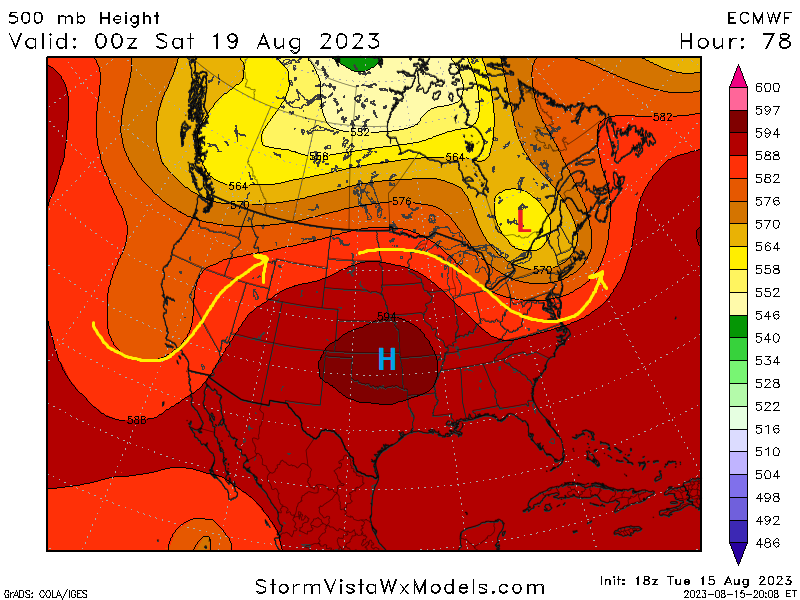
Heat in the central third of the country will continue to build through the weekend and into next week as high pressure continues to build over the region. Temperatures across the central and southern portions of the country will soar into the 100s and lower 110s, with heat indices reaching equally as high. These temperatures unfortunately will not look to relent either, as high pressure will stay firmly planted over the country. Over in the southwest, things will get more interesting over the weekend and into early next week.
In addition of continued rain chances, there is hints for an approaching decaying tropical disturbance impacting southern California and the rest of the southwest by the late weekend/early next week period. If indeed this solution holds, we could see the southwest receive anomalously high rainfall for the area. These trends will have to be monitored as the days progress.
[wpcode id=”41149″]
Travel Outlook
Main concerns for travel will be in the southwestern US, where isolated cases of flash flooding will be possible with heavier thunderstorms over the coming days. Caution when driving near burn scars and in canyons should be taken and turn around if flood waters are encountered. Outside of here, much of the country will be gripped by very high temperatures through the next several days and precautions to protect yourself from the heat should be taken.
[wpcode id=”41149″]
Conclusion
Main story over the coming days will be the rising heat throughout the central parts of the country, where temperatures will steadily climb into the 90s and 100s under a strengthening dome of high pressure. This high pressure will also have the added effect of virtually suppressing all organized rain chances underneath it, leaving dry to very dry conditions in its wake.
Over in the southwest, rain will continue to be a staple as more moisture gets fed into the region. It remains to be seen this far out, but there may be signs of an approaching tropical system that could bring very high to anomalous rain amounts to the area.


