Heat continues to be the main story as our ridge shifts northward and positions itself over the Central US. Many locations will see temperatures soar into the upper 90s and low 100s with heat indices reaching the 105 to 110 range. In the Southwest, we are monitoring a chance for a plume of tropical moisture to overspread the region as a result of Tropical Storm Hillary moving Northward. While we do not yet have certainty on the direct impacts of TS Hillary, we do know that the moisture the storm will bring northward could bring heavy rain, gusty winds, and flooding to the region. Let’s break down the details of our forecast below!

[wpcode id=”41149″]
Heat Across the Central US
The ridge which has sat over the Southwest US has begun to move over the Central US and intensify. This will allow record temperatures and high heat indices to impact large sections of Central US. Part of the reason why this ridge will amplify is the combination of lows on either side which will also intensify due to favorable jet positioning. The Low over the Great Lakes should intensify as it moves off to the Northeast allowing the High over the Central US to intensify. Additionally, a cut off Low off the coast of California will intensify as Tropical Storm Hillary is pulled northward. This will in turn allow the High over the Central US to amplify in response creating the large and impactful heatwave we will see. This high should remain in place for most of the current forecast period with only a slight break in sight for the Central US as the Ridge settles on the SE US for a short period of time before returning.
[wpcode id=”41149″]
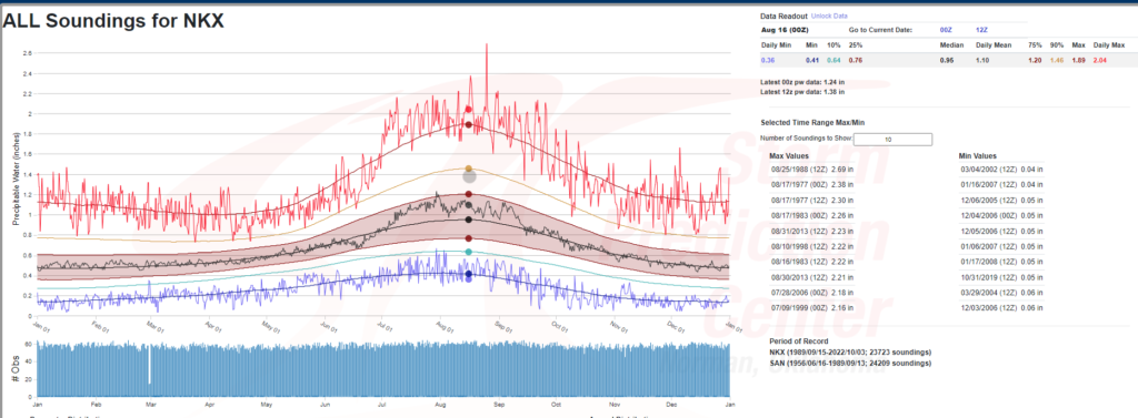
Southwest Tropical Moisture
A combination of an Upper low off the coast of California and Tropical Storm Hillary will result in a surge of tropical moisture into the Southwest. While direct impacts for Hillary to Southern California remain uncertain at this time, the region should see anomalous PWAT (precipitable water) in the 1-2 inches with some locations potentially seeing values in the 2.5 inch range. Normally, Southern California sees PWAT values slightly below an inch so this type of value range is abnormal and these values should reach inland to Arizona, Nevada, and other areas of the desert Southwest which will aid in bringing widespread rainfall of 2-4inches to the region.
[wpcode id=”41149″]
Additional Flooding Concerns Over New England and Florida
Some minor flooding concerns exists for other parts of the US as well. In New England, a low pressure system brings a marginal chance for flooding to the region which has seen higher then normal amount of rain lately. Due to the already saturate soils and higher then average river levels flooding in this region could happen quickly. In Florida, an axis of tropical moisture is the focus for the flooding threat there. While there isn’t a surface level or upper level focus for convection, widespread convection due to high moisture in the atmosphere is possible and could make travel hazardous.
[wpcode id=”41149″]
Extended Outlook
The heat looks to continue to stick around as the ridge moves around the country bringing impacts where it settles overhead. This should continue through out our extend forecast period. Tropical Storm Hillary should be monitored is a resident in the Southwest, partiality in Southern California, as a rare event seems to be unfolding which could allow for more direct tropical impacts to a region which doesn’t normally see tropical impacts. Finally, as we enter peak hurricane season for us along the Atlantic Coast its important to for us to remain aware as the African Easterly Wave Train gets underway and our chances overall tropical environment become more favorable for cyclone formation.
Travel Outlook
If traveling or working outdoors across the Central US be mindful of the heat impacts that you may find yourself in. Remember to stay hydrated, take breaks, and see medical assistance if you find yourself suffering from heat illness or heat stroke. Flooded roadways could impact travel across New England, Florida, and the Southwest with additional impacts to aircraft possible if thunderstorms form. Finally, if in Southern California keep monitoring the progress of Tropical Storm Hillary as impacts to you later in the week could happen.
Conclusion
Heat remains in place and brings its impacts far and wide this summer as the ridge builds across the Central US. Elsewhere a combination of potential flooding events could result in hazardous travel conditions in New England, Florida, and the Southwest. Finally, Tropical Storm Hillary could bring impacts to the Southwest later this week, but uncertainty lies in what those impacts may be so make sure to check back for updates!


