This week’s forecast will largely carry the same theme throughout the short and long-term: very hot and very dry. A rather potent high-pressure system will move in over the course of today and tomorrow and plant itself directly over the state for the next week or two. This will have the unfortunate effect of causing our temperatures to soar into the upper 90s to mid 100s and effectively shutting down substantial, organized rainfall potential. Hopefully, this will not be the case and we actually see some form of rainfall in the overnight hours, but as of right now, the chances of that are looking pretty bleak.
Quick side note before the start of this forecast, this will be the last edition of the Kansas Agriculture Forecast! It has been great every step of the way and I hope you guys found it useful in some capacity for your farms, ranches, or for general weather forecasts. Thank you all for reading these, and with that in mind, let’s take a look below and see what is going on over the next week or two.
[wpcode id=”41149″]
Short-Term Forecast
The scorching heat headed our way will at least look to stave off for the next day or two before it settles over the entire state. A weak cold front will move through the state this morning and help to limit temperatures over the next couple of days, keeping temperatures in the mid 80s to low 90s. Unfortunately, the passage of this cold front will not be strong enough to induce the formation of rain, but it will bring rather breezy conditions to the state, with winds of 10 to 20 mph possible this afternoon. This relief from the heat will carry over to tomorrow, albeit slightly warmer, with temperatures in the upper 80s to low 90s and less windy (at 5 to 15 mph). Beyond tomorrow, we will really begin to feel the heat as high pressure sets in.
[wpcode id=”41149″]
Long-Term Forecast
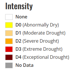
By the weekend, very strong high pressure (597-600 dam) will settle over the entirety of the state and cause us to dry out and bake. Temperatures will soar into the upper 90s to mid 100s for the rest of next week with little relief in sight. Our only saving grace is that this is going to be a “dry” heat, with dew point temperatures in the 50s through the week. So instead of feeling like a jungle, it’ll feel like an oven. The only place that may feel some humidity is in southeast Kansas, where dew point temperatures may stay in the low to mid 60s.
[wpcode id=”41149″]
Agriculture Forecast
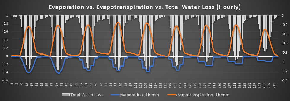
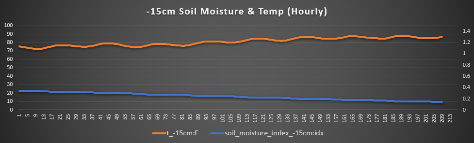
Holton, Topeka, and Valley Falls – Here around the capitol and areas north, soil conditions are on the better side of things (outside of far western Kansas), but that will be put to the test over this week. Temperatures will stay in the low to mid 80s for the next two days before rising to around the century mark for the next 5 days after. Winds will be largely out of the south and west at 5 to 15 mph, with sporadic gusts up to 25 possible. Soil temperatures will remain in the mid to upper 70s over the next 3 days before we top out around 85-87°F by mid next week. Total water loss rates will generally be consistent at 1.2 mm/hr, with a peak of 1.3 mm/hr possible on Sunday.
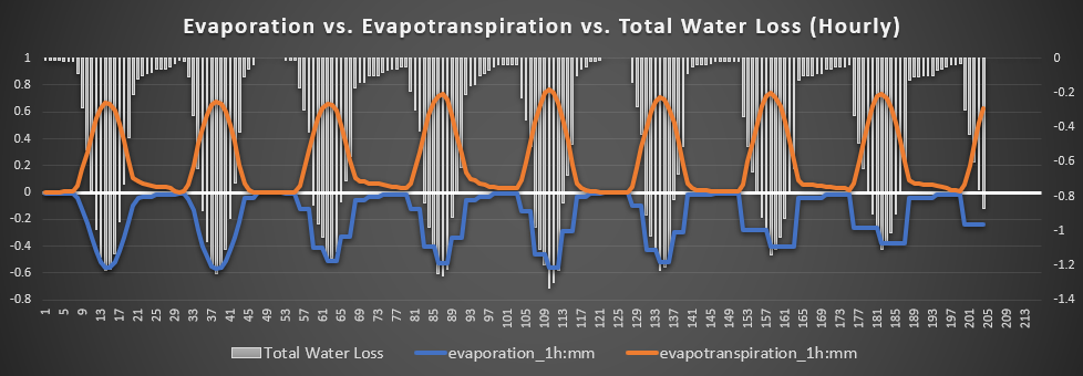
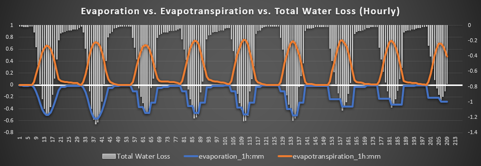
Parsons, Pittsburg, and Uniontown – Receiving some of the highest amounts of rainfall from the previous few days, southeast Kansas will see perhaps marginally better soil conditions than anywhere else in the state over the coming days. Air temperatures look to stay in the low to mid 80s for a couple days before we look to jump into the upper 90s to low 100s by the weekend and beyond. Winds will predominantly be out of the south and west at 5 to 15 mph, with gusts of 25 to 30 possible. Soil temperatures will steadily rise to a peak of around 88° by early next week. Total water loss rates will be fairly consistent, hovering at around 1.1 mm/hr daily.
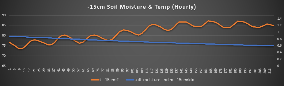
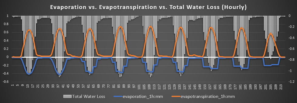
Hutchinson, McPherson, and Sterling – In one of the driest parts of the state, soil conditions will only look to get worse over the next week. Air temperatures will range in the low to mid 90s before spiking to the low to mid 100s by the weekend. Winds will stay largely out of the south and west at 5 to 15 mph, with gusts up to 30 possible. Soil temperatures will be on a steady climb before topping out at around 90°F by early next week. Total water loss rates will generally fluctuate between 0.9 mm/hr and 1.2 mm/hr as the week progresses.
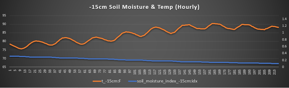
Burlingame, Lyndon, and Osage City – Just like out in the central Kansas, soil conditions will remain bleak over this next week. Air temperatures will remain pleasant in the upper 80s to low 90s for the first couple of days before jumping, like everywhere else, into the upper 90s and low 100s by the weekend. Winds will be mostly out of the south and west at 5 to 10 mph, with gusts of 25 to 30 possible. Soil temperatures will generally remain consistent, hovering at around 80°F before a gentle rise to 89-90°F by mid next week. Total water loss rates will also remain consistently between 1 mm/hr and 1.2 mm/hr over the next week as well.
[wpcode id=”41149″]
Climate Outlook
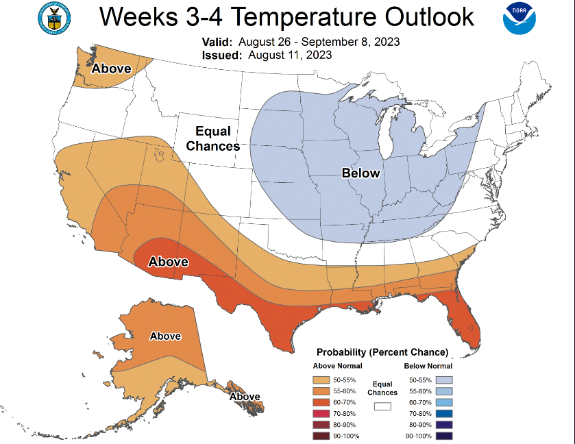
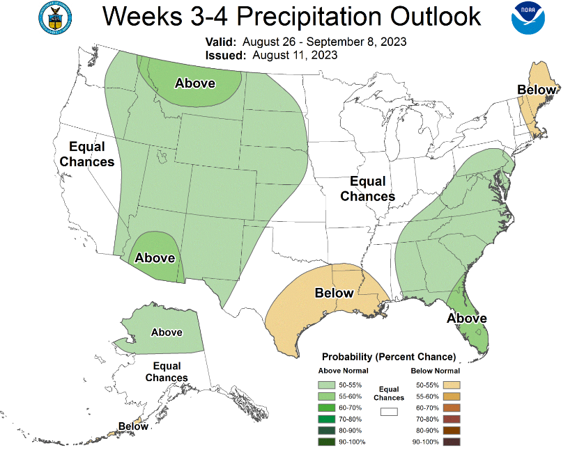
While the next two weeks will still be largely hot and dry, some relief could be on the way by weeks three and four. Looking at the last week in August and first week of September, conditions favoring more below-average temperatures and average rainfall chances will try to make its way back to the state. Continued drought relief is also still favored over the course of the next few months, but in the short-term, things are still going to hurt with these high temperatures and sparse rain chances.
[wpcode id=”41149″]
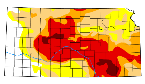
Drought Outlook
Drought conditions still remain largely unchanged across the state since last week. Some spotty minor improvements over central and eastern Kansas have taken place with last week’s rainfall, but all off that will feel for naught as we enter this period of upper 90s and low 100s and devoid of rainfall thanks to this strong high-pressure system.