Hot and dry is the forecast and has been for what seems like the longest time. This seemingly unbreakable pattern remains but for how long? Let’s figure that out together!
Also check out the video forecast!
[wpcode id=”41149″]
Heat This Week
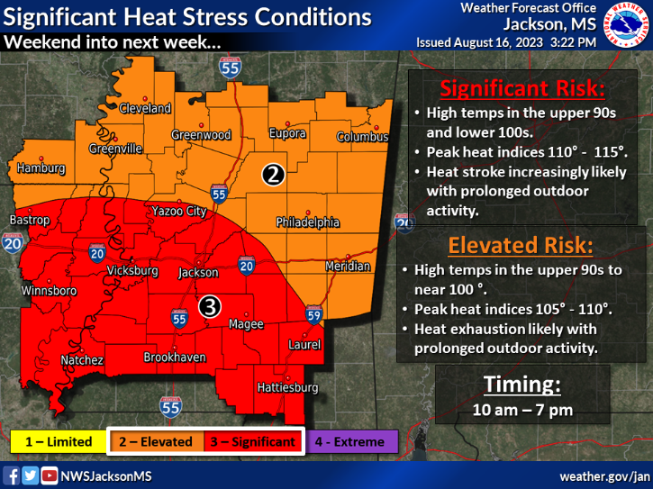
This weekend the temperatures will keep heating up as we see highs around the area in the low 100s and upper 90s. There are heat risk warnings sent out for much of the area about the high heat indices. Stating outside for prolonged periods of time can cause heat related illness so avoid being outside and drink lots of water. Unfortunately we won’t be getting much of a cool down in the evenings either with lows only in the upper 70s. This heat pattern is going to remain over the weekend and into next week.
[wpcode id=”41149″]
Dry Pattern Remains
Continuing the heat, some moisture will come into the atmosphere but will not give us any storm systems. We may see some possible scattered showers along the coast during the week. However moisture and hot air is a recipe for some tropical action in the Gulf. Some developments are forming out in the Atlantic which could lead to some storms at the end of the month. As for now we remain dry this week and for the foreseeable future.
[wpcode id=”41149″]
Extended Outlook
Looking ahead this hot and dry pattern will continue for the next two weeks. We will see a ridging pattern continue to keep the heat rolling with highs remaining in the upper 90s and low 100s. Some moisture will kick into the area but not enough for any major storm developments. In fact we will be slightly drier than normal for the end of the month. However the Gulf will see above normal moisture which could be possible developments coming at the end of the month.
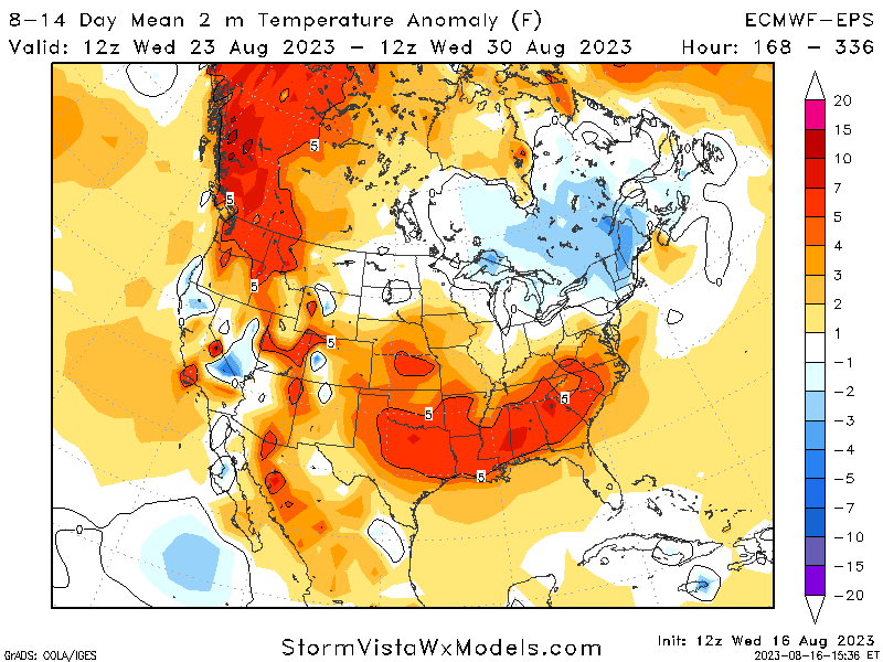
Temperature Mean for 8-14 Days 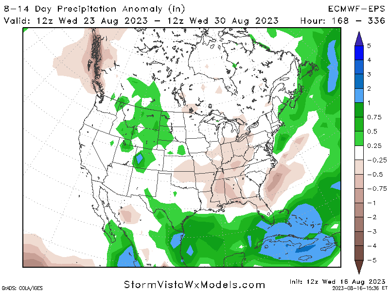
Precipitation Anomaly for 8-14 Days
[wpcode id=”41149″]
Regional Day-To-Day Forecast
Today: Mostly sunny. High temperatures in the upper 90s to low 100s. Winds northwest around 5 mph.
Tonight: Mostly clear. Low temperatures in the upper 70s. Winds south around 5 mph.
Friday: Sunny. High temperatures in the upper 90s to low 100s. Winds west around 5 mph.
Friday Night: Mostly clear. Low temperatures in the upper 70s. Winds west at 5 to 10 mph.
Saturday: Sunny. High temperatures in the upper 90s to low 100s. Winds west around 5 mph.
Saturday Night: Mostly clear. Low temperatures in the upper 70s. Winds south at 5 to 10 mph.
Sunday: Sunny. Chance of showers and thunderstorms in the afternoon. High temperatures in the upper 90s to low 100s. Winds west at 5 to 10 mph. Chance of rain 30%.
Sunday Night: Mostly clear. Low temperatures in the upper 70s. Winds southeast around 10 mph.
Monday: Mostly sunny. Chance of showers and thunderstorms in the afternoon. High temperatures in the upper 90s to low 100s. Winds northeast at 10 to 15 mph. Chance of rain 30%.
Monday Night: Partly cloudy. Chance of showers and thunderstorms. Low temperatures in the upper 70s. Winds east around 15 mph with gusts up to 25 mph. Chance of rain 20%.
Tuesday: Sunny. Chance of showers and thunderstorms. High temperatures in the upper 90s to low 100s. Winds east at 10 to 15 mph. Chance of rain 20%.
Tuesday Night: Partly cloudy. Chance of showers and thunderstorms. Low temperatures in the upper 70s. Winds southeast 5 to 15 mph. Chance of rain 20%.
Wednesday: Sunny. Chance of showers and thunderstorms. High temperatures in the upper 90s to low 100s. Winds northeast 5 to 10 mph. Chance of rain 20%.


