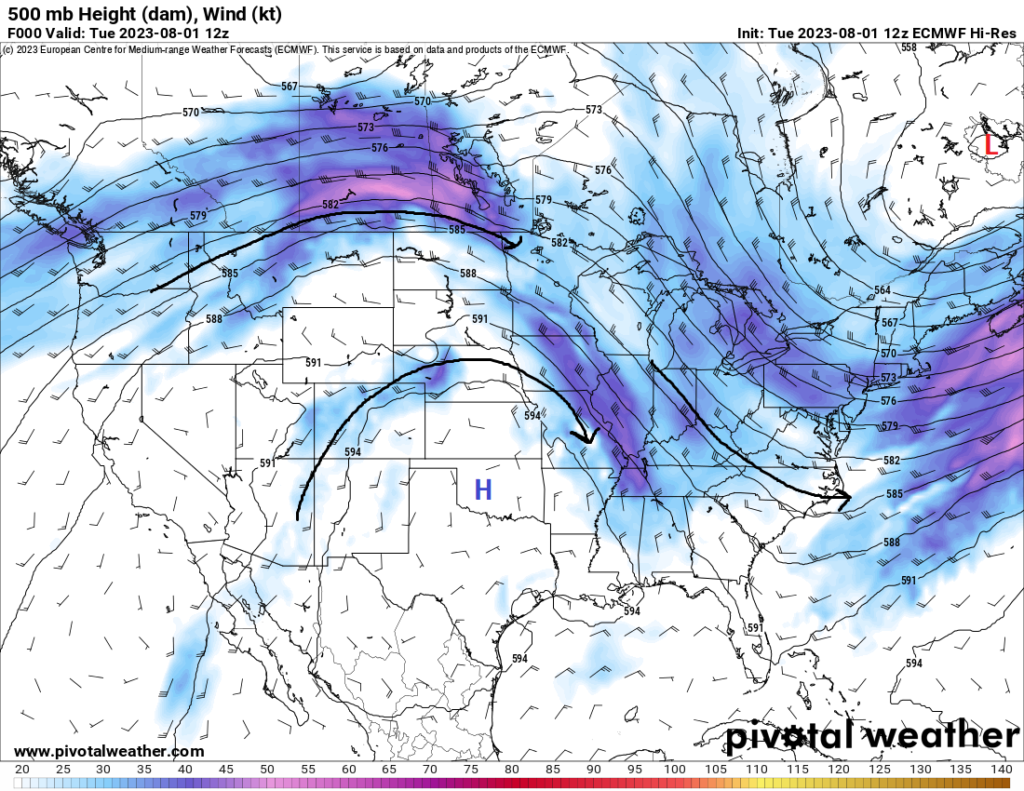
For many, the heat will stick around for just a few more days before we see a large-scale change in the overall synoptic pattern. Currently, high pressure over the western US continues to hang on for a few more days and general troughing in the eastern US still persists over the region. Eventually though over the next few days, this high-pressure system will start to break and get shoved down further south, which will allow for more widespread areas of rainfall across the central and northern tier of the country and the chance for cooler than average temperatures to settle in across the western US and northern Rockies. It’ll be a few more days, but we look to eventually break the deadlock of the past couple of weeks and welcome a change of pace in the weather.
Heat keeps baking the southern US
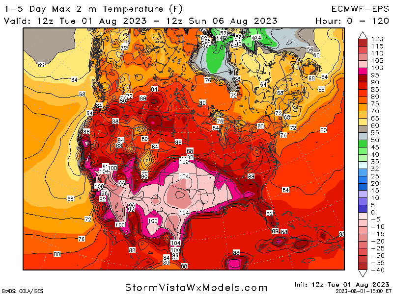
Unfortunately, one of the regions of the United States that will not see many major changes over the next week is the southern US. Down here, we will not be able to escape the grasp of this high-pressure system anytime soon, keeping us plenty hot and dry for the foreseeable future. Those at risk for the hottest temperatures over the next week will be those from the desert southwest eastward towards Louisiana. Temperatures over the next few days will be regularly in the upper 90s to low 100s across the region, with the highest heat indices being found around east Texas, Louisiana, Oklahoma, and Arkansas. Heat advisories and warnings will continue to be needed to cover those in the most extreme heat conditions over the coming days.
Chances for rain increases as temperatures fall in the Plains
While the next couple of days will still be rather hot, a steady cooldown in temperatures is expected as we head towards the weekend. Temperatures in the meantime will top out today between the upper 90s to mid 100s for many in the Central Plains. Thunderstorms, some severe, may also develop across portions of the High Plains and Missouri along a stationary front this afternoon and evening. Main hazards will be damaging winds and large hail, but a tornado cannot be ruled out either. By tomorrow, Thursday, and Friday, temperatures will try to sag back into the mid 80s to mid 90s as the dome of high pressure starts to break down. This will also allow for greater chances for showers and thunderstorms to seep in through the region as well.
Below average temperatures in the Great Basin and northern Rockies
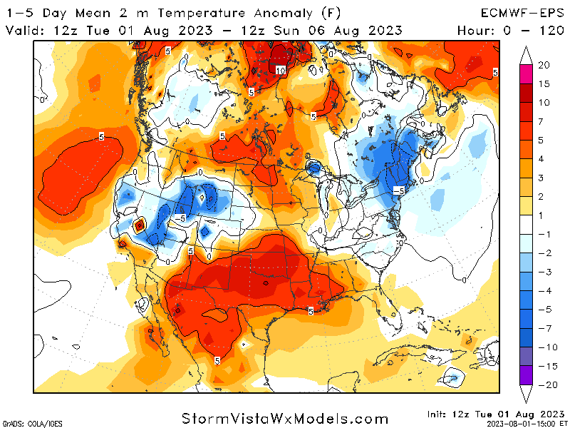
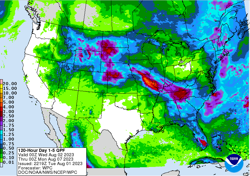
In contrast from the southern and central US, cooler-than-average temperatures will exist from portions of Nevada northeast towards Wyoming. A weak, but intensifying, surface low will steadily move eastward across the aforementioned states over the next few days, increasing rainfall potential and decreasing temperatures. Temperature anomalies will be averaging around 5-10 degrees below normal through the next 5 or so days, with the potential for locally lower temperatures (up to 15 degrees below normal) also possible, especially towards Wyoming. Heavy rainfall will be possible with these storms, as well as the potential for local to widespread flash flooding. QPF totals will likely be over an inch over the next 5 days, with local amounts of up to three inches possible closer towards the Dakotas and Wyoming.
Extended Outlook
Heading into the weekend, we will start to see a considerable breakdown of this high-pressure system and gradual retreat off to the south. More westerly and northwesterly flow will be evident across the country, paving the way for cooler temperatures and increased odds for large-scale storm systems to traverse the country. By late weekend and into early next week, a cold front will advance through most of the central US and drop temperatures considerably through next week. Increases in rain chances along and ahead of the front will also occur, with maybe some severe potential also being evident in the middle part of the country this weekend. It remains to be seen where any increased potential would be during next week, but the most likely location would be across the Central Plains. In conjunction with this, well-below average temperatures will be favored through next week in portions of the High Plains and northern Rockies, where temperature anomalies may get down to 10 to 20 degrees below normal. Missing out on this relief will be the far southern US, around the US-Mexico border, where excessive heat will continue to be prevalent.
Travel Outlook
Airport delays may be expected across the central US, as rounds of showers and thunderstorms move through the region daily. Deteriorating road conditions may also occur and caution should be taken when driving through areas where thunderstorms, some severe, are possible. Otherwise, largely uninterrupted travel conditions can be expected across most of the country over the coming days.
Conclusion
Just a few more days of heat for many before we will see a gradual, but noticeable change in the weather. High pressure that has sat over the western and central US for weeks now will begin to break down and allow for cooler temperatures and greater rain chances to encroach in around the Plains and portions of the Great Basin/northern Rockies. These rains, especially up north, will carry a substantial flood risk through Wyoming and into the Dakotas. In contrast, this relief unfortunately will not make it to the far southern US, where the heat will continue to linger around for the foreseeable future.


