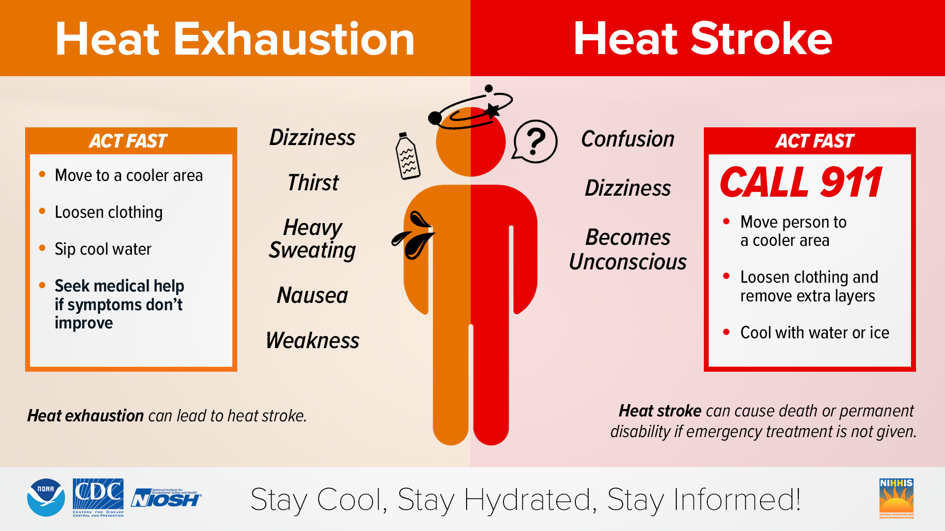
Let’s see here… Early August? Check. Ridge over the Southern U.S.? Check. Gulf Moisture moving North unchecked? Check. Guess it’s another hot and humid summer right on schedule for this region. Dew points are in the upper 60s to low 70s across the region. This paired with temperatures in the upper 90s to low 100s have resulted in heat indices being in the 105 degree range with some locations reaching 110 degrees.

This type of heat is definitely not one to be messed around with, and proper precautions to protect yourself from heat-related illnesses should be taken. Fortunately (or unfortunately depending on the timing), the chance for scattered showers and thunderstorms will exist virtually every day across the majority of our region. Storm chances will turn into a game of chance however as some locations see relief while others miss out.
[wpcode id=”41149″]
Short Term Outlook
The ever present story this week is Heat. With a ridge sitting squarely over the Plains, and expanding its influence over our region, we have continued to just cook under this dome of heat. This ridge is also doing very little to keep Gulf moisture from moving northward which keeps heat indices high. Extreme Heat Warnings are in effect for Louisiana and Mississippi where these dangerous temperatures are to be expected. Portions of Alabama are not currently under a warning for heat as their index values are expected to be closer to 100 rather then 105-110, but make no mistake that at risk populations could find themselves at risk here too.
Daily pulse storms resulting from the diurnal heating cycle will also be possible each day, but it is difficult to say specifically who is going to get rain or not. Overall, chances for showers and thunderstorms will exist across the region in some capacity daily.
Widespread convection looks unlikely in the short term as the ridge works to suppress most convection, but after Thursday chances look a bit better as the ridge begins to weaken slightly and allowing the trough to place more influence across the south. This should create an area where increased divergence aloft which will aid in storm development
[wpcode id=”41149″]
Long Term Outlook
Starting next week it will be a game to see if this ridge finally decides to move. If the ridge slides West like models seem to be indicating, then we should see enhanced Northwesterly flow which will result in more widespread storm chances. Additionally, not being under the direct influence of the ridge will allow more of this warm air to escape the surface and provide some “relief”. (This could result in temps in the mid to upper 90s which would in term lower heat index values). If the ridge doesn’t move, then the likelihood of meaningful rainfall will drop significantly and temperatures will remain what they are currently.
[wpcode id=”41149″]
REGIONAL DAY-TO-DAY FORECAST
Wednesday: Partly cloudy skies and hot, with a stray shower or thunderstorm possible. High temperatures in the upper 90s to low 100s. Heat indices may reach up to 110°F. Chance of rain 20%.
Wednesday night: Mostly clear skies. Low temperatures in the upper 70s to low 80s.
Thursday: Partly cloudy skies and hot, with showers and thunderstorms likely. High temperatures in the upper 90s to low 100s. Heat indices may reach up to 110°F. Chance of rain 60%.
Thursday night: Mostly cloudy skies, with a chance of showers and thunderstorms. Low temperatures in the upper 70s to low 80s. Chance of rain 30%.
Friday: Mostly cloudy skies and hot, with a chance of showers and thunderstorms. High temperatures in the upper 90s to low 100s. Heat indices may reach up to 110°F. Chance of rain 30%.
Friday night: Partly cloudy skies, with a stray shower or thunderstorm possible. Low temperatures in the upper 70s to low 80s. Chance of rain 20%.
Saturday: Mostly sunny skies and hot, with a chance of showers and thunderstorms. High temperatures in the upper 90s. Heat indices may reach up to 110°F. Chance of rain 30%.
Saturday night: Partly cloudy skies, with a stray shower or thunderstorm possible. Low temperatures in the upper 70s to low 80s, Chance of rain 20%.
Sunday: Mostly sunny skies and hot, with a stray shower or thunderstorm possible. High temperatures in the upper 90s to low 100s. Chance of rain 20%.
Sunday night: Mostly clear skies. Low temperatures in the upper 70s to low 80s.
Monday: Mostly sunny skies and hot. High temperatures in the upper 90s to low 100s.
Monday night: Partly cloudy skies, with a stray shower or thunderstorm possible. Low temperatures in the upper 70s to low 80s. Chance of rain 20%.
Tuesday: Mostly sunny skies and hot. High temperatures in the upper 90s to low 100s
Tuesday night: Partly cloudy skies. Low temperatures in the upper 70s to low 80s. 10% chance of rain.


