Check out the video forecast!
[wpcode id=”41149″]
Heat Warnings for Today
Hot, hot, hot that’s the forecast for today! Clear weather today alongside these temperatures with some afternoon thunderstorms for the coming days. The heat will not be dying down anytime soon. Let’s look at how hot it will be and for how long!
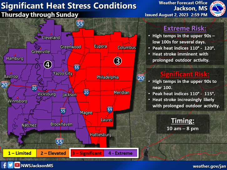
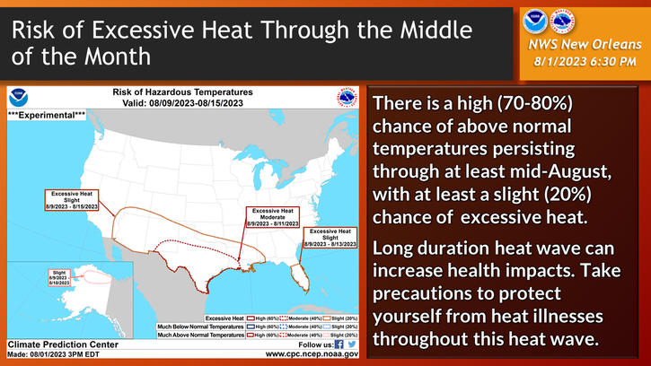
The heat is kicking this week and all the local weather offices in the area are sharing their warnings for our region. The Jackson Mississippi office put out a warning about heat stress conditions. The western half of the state is under extreme risk due to the super high temperatures. Temperatures will be in the 100s and the heat index will be in the 110-120s. The eastern half of the state is under significant risk. Highs will still be in the upper 90s to 100s and heat indices will be high as well. The New Orleans office predicts this pattern to last til mid August which we predict as well.
Be cautious in these hot temperatures. Being outside for extended periods of time can have serious health risks. Stay hydrated and avoid being in direct sun for long periods of time. Even 20-30 minutes can be deadly especially being active. Limit time outdoors and stay safe!
[wpcode id=”41149″]
Scattered Rainfall
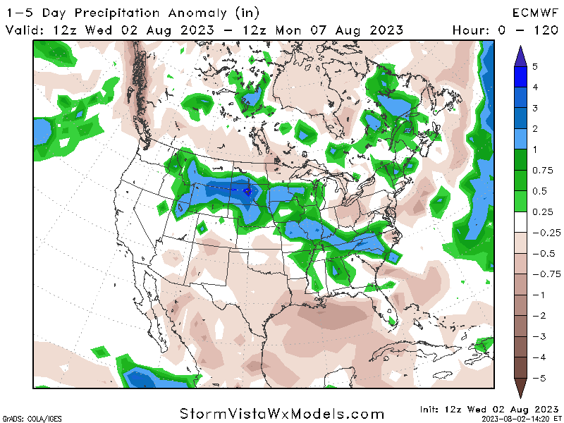
With the hot temperatures some cooling rain sounds like just the trick to give some relief. Well forget about that because rainfall is not a big thing that’s going to occur this week. We will be getting some afternoon thunderstorms that will just continue to keep the air moist and muggy. Central and northern Mississippi and Alabama are most likely to see these storms while the coast stays dry. We see a chance for the central and northern MS, AL area to see slightly above average precipitation while the coast is more normal. This doesn’t mean lots of rain or no rain it just means above average.
[wpcode id=”41149″]
Heat to Stay
We are seeing a major ridge sweep through our area which is contributing to the super hot temperatures. This ridging pattern will continue over the weekend into next week but die down a bit. However temperatures won’t cool that quickly as we will see highs in the upper 90s to low 100s for the next week with lows only dropping to the mid to upper 70s. Afterwards temperatures will go slightly down to more normal temperatures.
[wpcode id=”41149″]
Extended Outlook
Looking beyond next week we see temperatures in our area cool down slightly and be not as extreme. It will still be August heat but not much above normal as it will be. The west and southwest will take some of the extreme temperatures. As for rainfall we will stay more on average for the beginning/middle of August as we don’t see much tropical action for the next two weeks, however later into August this normal pattern may shift into the wet pattern as the Atlantic usually heats up in the later half of August.
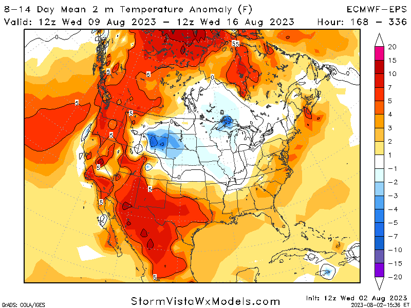
Temperature Anomaly for 8-14 Days 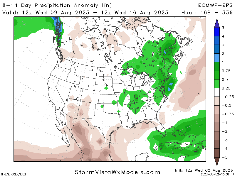
Precipitation Anomaly for 8-14 Days
[wpcode id=”41149″]
Regional Day-To-Day Forecast
Today: Sunny. High temperatures in the upper 90s to low 100s. Winds west around 5 mph.
Tonight: Mostly clear. Low temperatures in the upper 70s. Winds south around 5 mph.
Friday: Sunny. High temperatures in the upper 90s to low 100s. Winds west around 5 mph.
Friday Night: Partly cloudy. Low temperatures in the upper 70s. Winds south southwest around 5 mph.
Saturday: Sunny. Chance of showers and thunderstorms. High temperatures in the upper 90s to low 100s. Winds west around 5 mph. Chance of rain 30%.
Saturday Night: Partly cloudy. Chance of showers and thunderstorms. Low temperatures in the upper 70s. Winds south around 5 mph. Chance of rain 30%.
Sunday: Sunny. Chance of showers and thunderstorms. High temperatures in the upper 90s to low 100s. Winds southwest 5 to 10 mph. Chance of rain 30%.
Sunday Night: Partly cloudy. Chance of showers and thunderstorms. Low temperatures in the upper 70s. Winds southwest around 5 mph. Chance of rain 30%.
Monday: Sunny. Chance of showers and thunderstorms. High temperatures in the upper 90s to low 100s. Winds southwest 5 to 10 mph. Chance of rain 40%.
Monday Night: Mostly clear. Chance of showers and thunderstorms. Low temperatures in the upper 70s. Winds southwest 5 to 10 mph. Chance of rain 30%.
Tuesday: Sunny. Chance of showers and thunderstorms. High temperatures in the upper 90s to low 100s. Winds southwest 5 to 10 mph. Chance of rain 60%.
Tuesday Night: Mostly clear. Chance of showers and thunderstorms. Low temperatures in the upper 70s. Winds southwest 5 to 10 mph. Chance of rain 40%.
Wednesday: Mostly sunny. Chance of showers and thunderstorms. High temperatures in the upper 90s to low 100s. Winds southwest 5 to 10 mph. Chance of rain 50%.


