Similarly to the last few days across the country, the interior of the country will continue to see showers and thunderstorms, some being severe, and the southern and southwest US keeps on baking in high temperatures. Will we see a change in the long-term pattern, or will we see more of the same weather? Let’s take a look down below and decipher what all is going on around the country.
Thunderstorms sweeping the Plains and Mississippi River valley
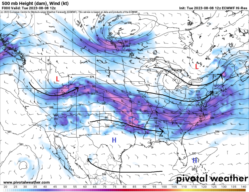
A rather potent shortwave trough is traversing its way across the central US and is expected to help trigger severe thunderstorms across portions of the Mississippi and Ohio River valleys today before moving off and affecting portions of the Mid-Atlantic tomorrow. Ongoing clusters of thunderstorms from Kansas and Nebraska are slated to enter Missouri and Arkansas in the morning hours and may produce some marginally severe wind gusts and small hail. Once these storms move out by early afternoon, enough atmospheric recovery will sustain a greater severe threat during the evening and overnight hours as another round of convection forms in southeast Kansas/southwest Missouri and moves east-southeast. Sheer profiles and robust instability will support supercellular development early with all hazards being possible before a quick transition to a multicell/linear mode occurs by sunset. Once storms get to this stage, damaging winds and embedded tornadoes will be the main hazards as they progress eastward into the night.
By tomorrow, this system moves off towards the eastern US and may provide another focus for severe weather during the day. As the attendant cold front moves through with the advancing yesterday’s storms, a marginally unstable atmosphere may provide the necessary ingredients to support one or two severe thunderstorms, but overall, the majority of these storms look to remain below severe limits at this time.
Texas, Desert Southwest still facing searing heat
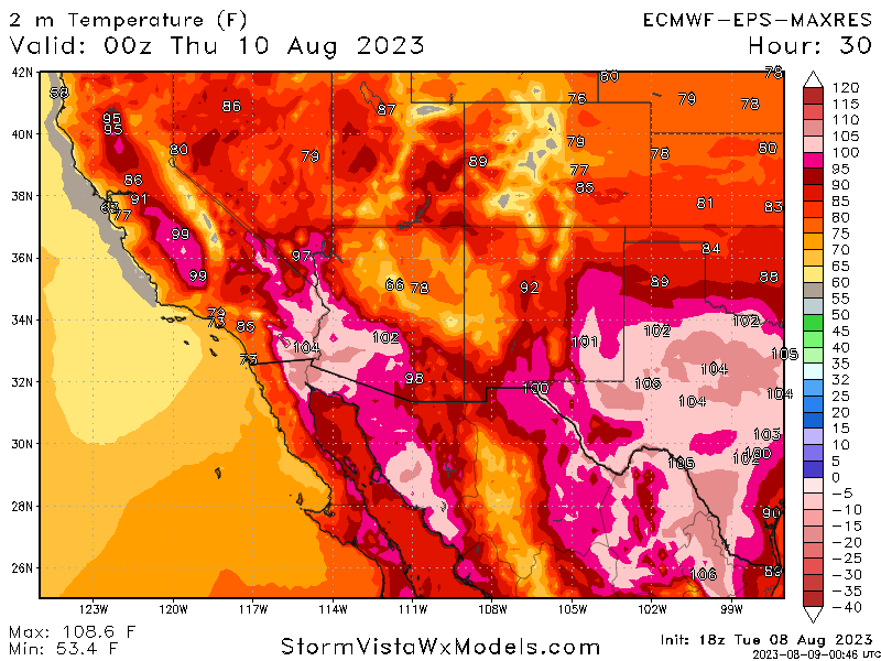
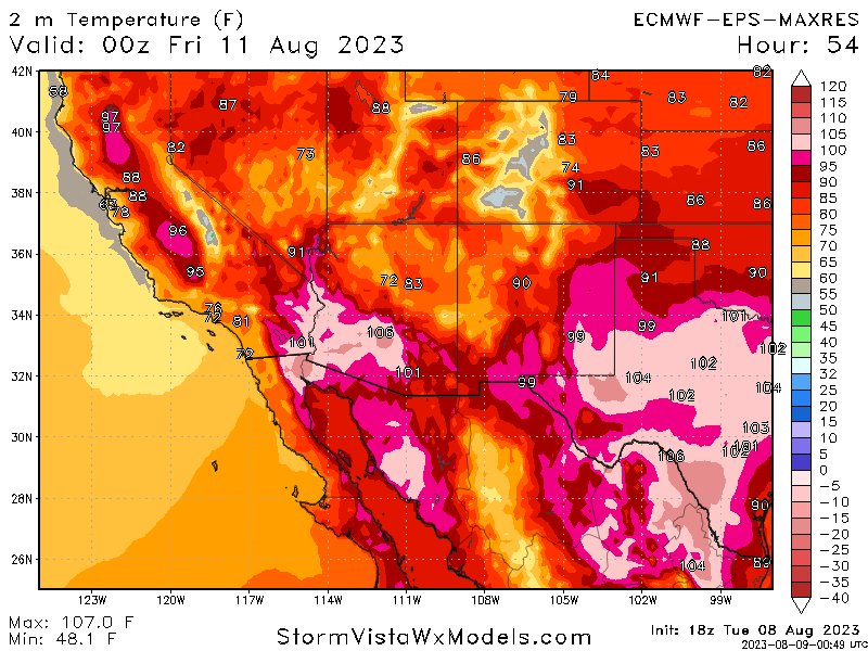
Contrasting from areas further north and east, Texas will be largely devoid of any organized convective activity and remain hot over the forecast period. The main culprit responsible for this pattern of persistence is still the same culprit that has kept temperatures near or above the century mark: a dome of high pressure sitting over the southern tier of the United States. This pattern will only look to stick around over the next week or so, keeping a large chunk of this corner of the country plenty warm. Further west into New Mexico and Arizona, while it still may feel like summertime, there will at least be some relief due to the monsoon rains currently in full force throughout the desert states. Flash flooding and severe winds/large hail may still pose a problem with the stronger of storms so be sure to keep your eyes on the weather and listen for any updates or weather alerts from these storms.
Extended Outlook
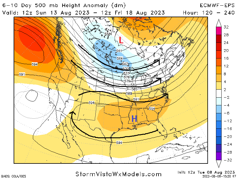
Long-term guidance is hinting at the possibility for increased thunderstorm activity across the Great Lakes region and northern US towards the weekend, as the belt of strong mid-level flow gets displaced northward from increasing high pressure. Details on potential severity or intensity of any storm activity is unclear at this time, but trends should be monitored as the days progress and more information becomes clearer. Further to the south, as aforementioned, high pressure will slowly build back northward from the southern US and help keep the heat hanging around for the foreseeable future.
Travel Outlook
Travel may be impacted by strong to possibly severe thunderstorms across the Mississippi and Ohio River valleys over the next couple of days. Expect airport delays and cancellations with these passing storms and pay attention to quickly deteriorating road conditions if your route takes you through areas where thunderstorms are expected. Be mindful of storms in the southwest US also and keep a lookout for flash flood events and/or potential microburst from decaying thunderstorms.
Conclusion
Showers and thunderstorms will be possible today and tomorrow across portions of the central and eastern US, where all hazards are possible. It will remain to be seen how the progression plays out, but as of right now, the greatest chance for severe weather will be today across the Mississippi River valley. Further down south, high pressure will be persistent across the region and help to keep the heat sticking around for the long-term. Looking ahead, renewed chances for showers and storms may exist closer towards the northern US as the vigorous mid-level jet and any associated disturbances within the flow gets pushed northward as the aforementioned high pressure in the southern US expands northward.


