The extreme heat remains in our area as we stay pretty dry for the next few days. This week scattered showers in the afternoon will be around. This pattern will be around to stay for a while. Let’s get into more detail!
[wpcode id=”41149″]
Extreme Heat Remains
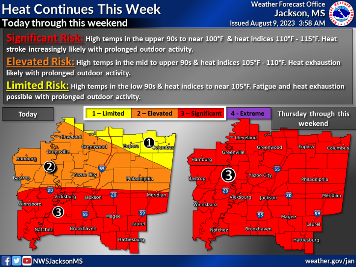
The extreme heat continues again this week and into next week as this ridging pattern continues in this area. Heat indices will be super high which means being outside for extended periods of time will be dangerous. All of our area will be under significant risk meaning heat stroke and dehydration are highly possible when outside for long periods of time. Highs will be in the upper 90s and low 100s but the lows won’t give much relief only cooling to the upper 70s. Be cautious when going outdoors and stay safe!
[wpcode id=”41149″]
Afternoon Showers This Week
The next few days should be pretty dry with some storms to the east of our area today. It will stay nice and sunny which does increase the heat in the area. Over the weekend scattered thunderstorms in the afternoon will be around. This will be the common theme for the week just some afternoon scattered thunderstorms and showers. Our region will remain fairly dry over the next week other than the afternoon precipitation.
[wpcode id=”41149″]
Extended Outlook
Looking ahead we will continue to see hot temperatures for the next two weeks with highs remaining in the mid to upper 90s. This heat will be more on par for normal August highs. As for precipitin we will most likely continue to see the pattern of afternoon showers continue with rainfall staying on average or drier for this time of year. No major storm systems are likely as of right now for the next two weeks.
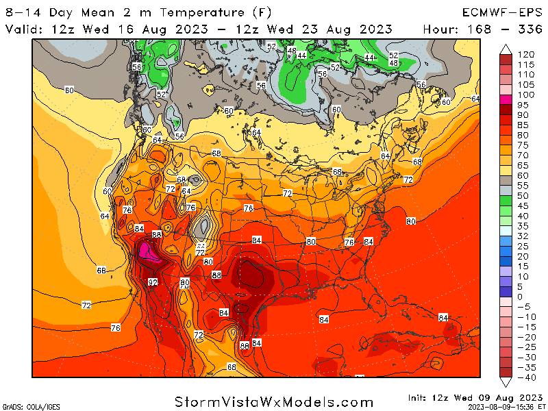
Temperature Mean for 8-14 Days 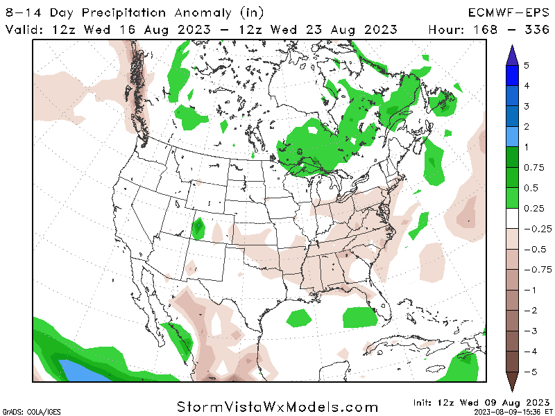
Precipitation Anomaly for 8-14 Days
[wpcode id=”41149″]
Regional Day-To-Day Forecast
Today: Sunny. High temperatures in the upper 90s to low 100s. Winds southwest at 5 to 10 mph.
Tonight: Mostly clear. Low temperatures in the upper 70s. Winds southwest around 5 mph.
Friday: Sunny. Chance of showers and thunderstorms in the afternoon. High temperatures in the upper 90s to low 100s. Winds west southwest around 5 mph. Chance of rain 20%.
Friday Night: Mostly clear. Low temperatures in the upper 70s. Winds northwest around 5 mph.
Saturday: Sunny. Chance of showers and thunderstorms in the afternoon. High temperatures in the upper 90s to low 100s. Winds west around 5 mph. Chance of rain 30%.
Saturday Night: Partly cloudy. Low temperatures in the upper 70s. Winds south southwest around 5 mph.
Sunday: Sunny. Chance of showers and thunderstorms in the afternoon. High temperatures in the upper 90s to low 100s. Winds west around 5 mph. Chance of rain 30%.
Sunday Night: Partly cloudy. Low temperatures in the upper 70s. Winds south at 5 to 10 mph.
Monday: Mostly sunny. Chance of showers and thunderstorms. High temperatures in the upper 90s to low 100s. Winds west at 5 to 10 mph. Chance of rain 30%.
Monday Night: Partly cloudy. Chance of showers and thunderstorms. Low temperatures in the upper 70s. Winds south at 5 to 10 mph. Chance of rain 20%.
Tuesday: Sunny. Chance of showers and thunderstorms. High temperatures in the upper 90s to low 100s. Winds west at 5 to 10 mph. Chance of rain 40%.
Tuesday Night: Partly cloudy. Chance of showers and thunderstorms. Low temperatures in the upper 70s. Winds west 5 to 10 mph. Chance of rain 40%.
Wednesday: Sunny. Chance of showers and thunderstorms. High temperatures in the upper 90s to low 100s. Winds south 5 to 10 mph. Chance of rain 40%.


