As Nick mentioned yesterday in his post, this low pressure system moving up the Gulf will impact us directly with more rain chances. It’s a bit of a doozy since it’s almost subtropical in nature and also acts like a regular low. That being said, we’ll see a good chance of rain for the next few days until it finally moves inland by Monday. With its subtropical nature, we’ll see higher rain chances in the afternoon to evening hours.
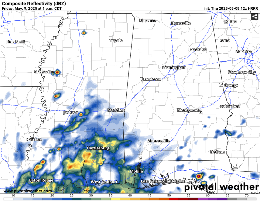
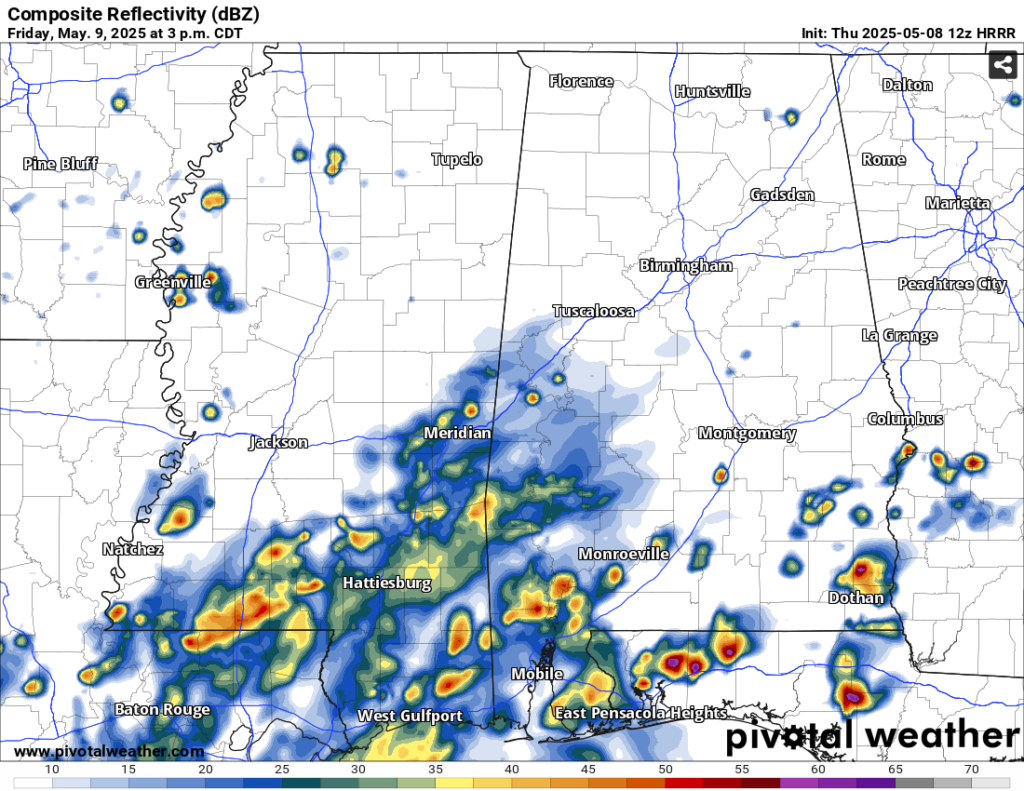
Tonight, we’ll have a limited chance of rain in the evening hours, but otherwise our main concern is fog in the early morning hours. By Friday, we’ll have our first wave of the “outer bands” of the low which means a good chance of showers and thunderstorms in the afternoon. The NWS in Jackson is calling for a Marginal (1/5) risk for severe weather which includes hail and strong wind gusts due to the instability and high lapse rates for this type of system. Judging by the models pumping out a couple of stronger cells, I can see a few developing in the afternoon.
Saturday will be a mixed bag of storms throughout most of the day as the low shifts towards the northeast. We likely won’t see the worst of it so much as the Florida panhandle will, but on and off showers and thunderstorms are possible. This will likely be our coolest day with highs only in the upper 70s but mainly due to the cloud cover and rain. By Sunday we’ll have another mixed bag of storms as the low moves inland and will be on and off during the day. By the end of this, we may see another inch to 2 inches of rain.
Monday will be our last real rainy day with some leftover showers from the low. This will begin to move out and fizzle as a high pressure builds behind it in the Gulf. Afterwards, we begin to warm up on Tuesday and Wednesday with highs in the mid to upper 80s.
[wpcode id=”41179″]
Regional Day-to-Day Forecast
This Afternoon – Sunny, with a high in the mid 80s. West northwest wind around 5 mph.
Tonight – A slight chance of showers in the evening. Patchy fog before 1am, then patchy fog after 5am. Otherwise, increasing clouds, with a low in the mid 60s. Calm wind. Chance of precipitation is 20%.
Friday – A slight chance of showers in the morning, then showers likely and possibly a thunderstorm in the afternoon. Patchy fog before 9am. Otherwise, mostly cloudy, with a high in the low 80s. Calm wind becoming north northwest around 5 mph in the afternoon. Chance of precipitation is 70%. New rainfall amounts between a quarter and half of an inch possible.
Friday Night – A 40 percent chance of showers before midnight. Mostly cloudy, with a low in the low 60s. North wind around 5 mph becoming calm.
Saturday – A slight chance of showers in the morning, then showers likely and possibly a thunderstorm in the afternoon. Partly sunny, with a high in the mid 70s. North northeast wind 5 to 10 mph. Chance of precipitation is 60%. New rainfall amounts of less than a tenth of an inch, except higher amounts possible in thunderstorms.
Saturday Night – A 30 percent chance of showers before midnight. Mostly cloudy, with a low around 59. North northeast wind around 5 mph.
Sunday – A slight chance of showers in the morning, then showers likely and possibly a thunderstorm in the afternoon. Mostly cloudy, with a high in the mid 70s. Northeast wind around 5 mph. Chance of precipitation is 60%.
Sunday Night – A 30 percent chance of showers and thunderstorms before midnight. Mostly cloudy, with a low around 58. North northeast wind around 5 mph becoming calm in the evening.
Monday – A 50 percent chance of showers and thunderstorms. Partly sunny, with a high in the upper 70s. Calm wind becoming west southwest around 5 mph in the afternoon.
Monday Night – Patchy fog between midnight and 3am. Otherwise, partly cloudy, with a low in the upper 50s.
Tuesday – A 20 percent chance of showers and thunderstorms. Sunny, with a high in the mid 80s.
Tuesday Night – Mostly clear, with a low in the low 60s.
Wednesday – Sunny, with a high in the upper 80s.
[wpcode id=”41149″]


