Hello everyone! This weekend is nothing unexpected, where we have our typical summer weather pattern for the weekend. Expect high temperatures in the low to mid 90s, and scattered afternoon and early evening showers and thunderstorms. Moving into next week, high heat will be a concern, with rising temperatures and high humidity rolling into our region. Let’s get into the details:
Today’s Atmospheric Setup
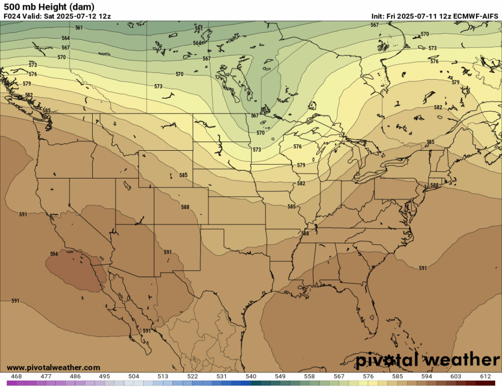
In the upper-air, we have a trough over the Midwest and a ridge over the Northeast. With the way that our area is positioned in this setup, we can expect some rain and possibly a thunderstorm, but nothing too severe.
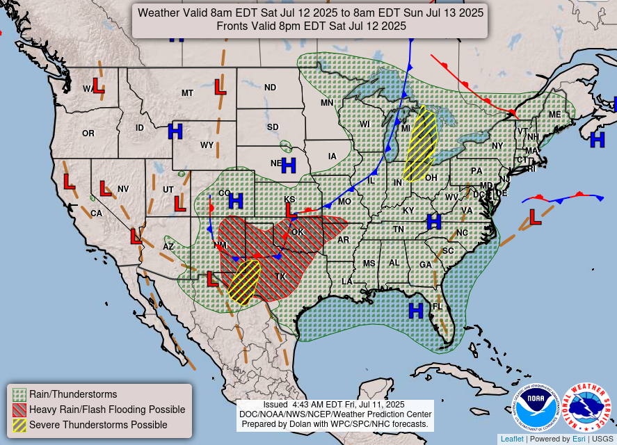
Looking closer to the surface, there are rain and thunderstorms forecasted for our entire region, with an area of high pressure in the Gulf funneling in some Gulf moisture. Fortunately, it is unlikely that these storms will be severe. For today, this will be a popup afternoon shower or thunderstorm situation.
This Weekend’s Weather:
This weekend won’t be a very special one weather-wise, as we can expect temperatures in the low to mid 90s with scattered afternoon and/or early evening showers. A thunderstorm or two popping up cannot be ruled out either. It is important to note that there is a lot of humidity building in, so starting around tomorrow it will start to feel pretty muggy:

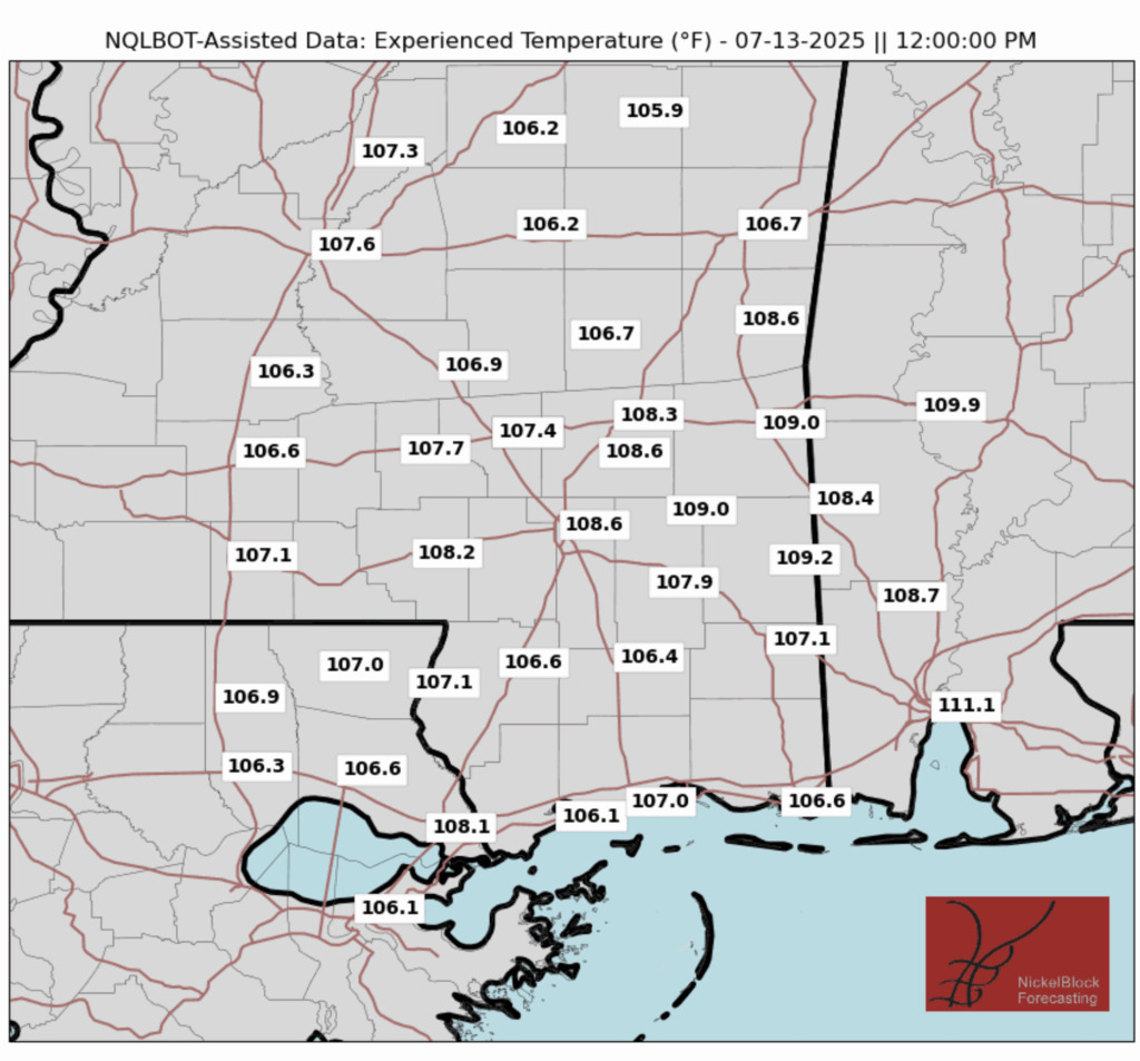
Looking at our “feels like” temperatures for today, there will be some more seasonable temperatures as you move farther away from the coast, but around the Hattiesburg area it will still feel close to 110 degrees. Tomorrow, experienced temperature will be a bit more uniform across the area, with every location breaking 105 degrees.
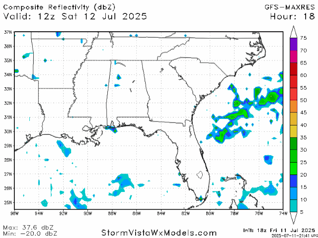
Here’s a look at the radar for the weekend showing scattered showers in the afternoon and early evening:
Looking into Next Week:

High humidity will be dominating our region next week, and with temperatures reaching the high 90s, high heat indices will definitely be a concern. We can probably expect a heat advisory or two toward the middle of next week. During this time there will also be some zonal flow going on in the upper-air, which can help support warm conditions, but also may help minimize our afternoon storms.
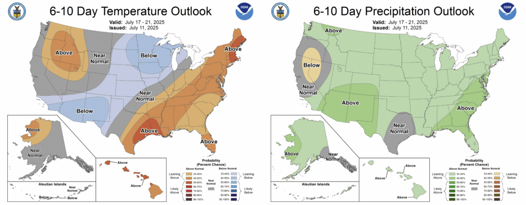
Looking at the CPC’s temperature and precipitation outlooks for the end of next week and toward the beginning of the following week, we may be headed toward some above-normal temperatures and rainfall. Although, for both temperature and precipitation, the chance for an above-normal 6-10 days is only around 40-50%, so I don’t expect any major anomalies except for some slightly higher temperatures.
Regional Day-to-Day Forecast:
Today: Sunny during the morning with a chance of showers and thunderstorms in the afternoon. Highs in the low to mid 90s. Chance of precipitation 40%.
Tonight: Chance of showers and thunderstorms early in the evening, then mostly clear. Lows in the mid 70s. Winds will be calm, around 5 mph. Chance of precipitation 30%.
Sunday: Sunny during the morning with a chance of showers and thunderstorms in the afternoon. Highs in the mid 90s during the day and lows in the mid 70s at night. Chance of precipitation 50%.
Monday: Sunny during the morning with a chance of showers and thunderstorms in the afternoon. Highs in the mid 90s during the day and lows in the mid 70s at night. Chance of precipitation 40%.
Tuesday: Sunny during the morning with a chance of showers and thunderstorms in the afternoon. Highs reaching the high 90s during the day and lows in the mid 70s at night. Chance of precipitation 30%.
Wednesday: Mostly sunny during the morning with a chance of showers and thunderstorms in the afternoon. Highs reaching the high 90s during the day and lows in the mid 70s at night. Chance of precipitation 30%.
Thursday: Mostly sunny during the morning with a chance of showers and thunderstorms in the afternoon. Highs reaching the high 90s during the day and lows in the mid 70s at night. Chance of precipitation 40%.
Friday: Sunny during the morning with a chance of showers and thunderstorms in the afternoon. Highs in the mid 90s during the day and lows in the mid 70s at night. Chance of precipitation 50%.
Saturday: Sunny during the morning with a chance of showers and thunderstorms in the afternoon. Highs in the mid 90s during the day and lows in the mid 70s at night. Chance of precipitation 70%.


