Are you ready for a heat wave? The ridge building and the high pressure over the gulf will ensure some very warm temperatures today. A system will move through bringing elevated rain chances the rest of this week, before a typical summertime pattern returns next week.
TODAY
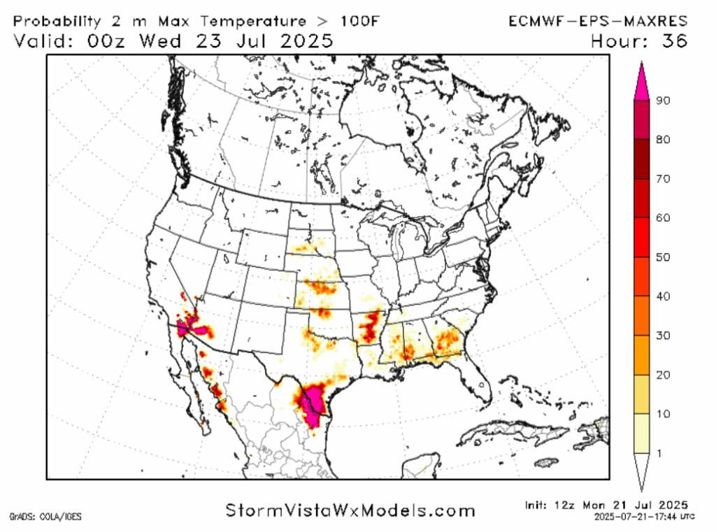
Highs will reach into the mid to upper 90s today, at least. Despite humidity close to the ground, rain is unlikely as there won’t be enough lift in the atmosphere, and the air aloft is much drier. Notably, the European model composite does have parts of the forecast area, mainly near the Alabama/Mississippi border, under a nearly 40% chance for a rare 100+ degree high temperature. Winds will be light and variable as well, so there will be little to no relief from the sweltering conditions.
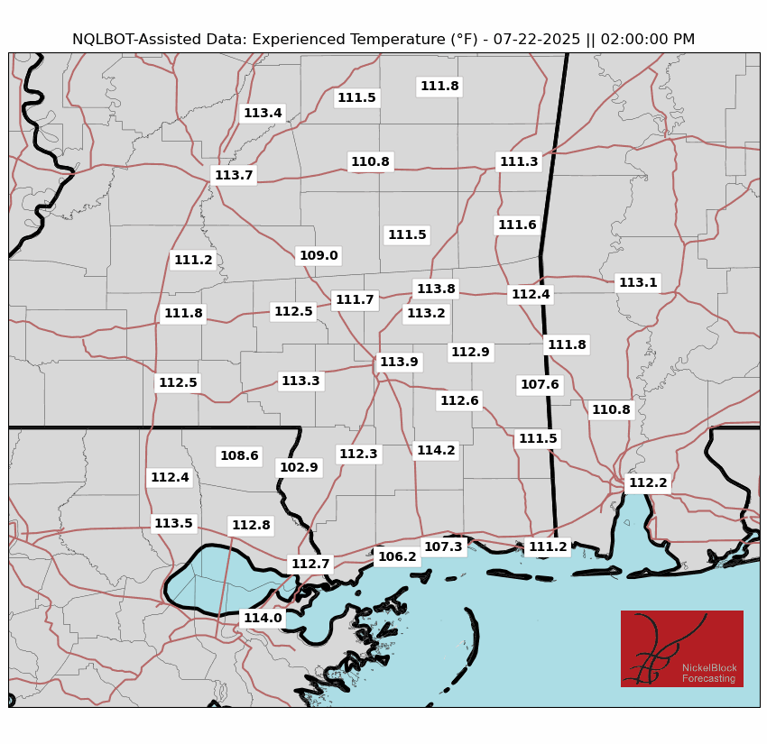
The apparent temperatures anywhere besides the Gulf Coast (where sea breezes will make the heat slightly less unbearable) will likely blow past 110 degrees. Peak temperatures as usual will be in the early to mid afternoon. Extreme Heat Warnings might be issued by the NWS for today and/or tomorrow.

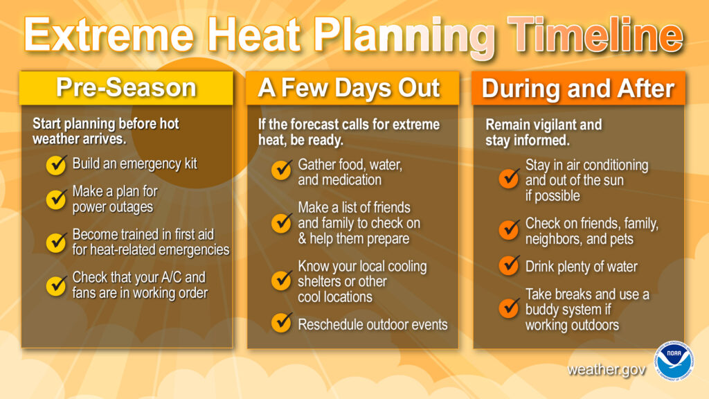
The heat will be downright dangerous today. We remind you of all the heat safety precautions: Drink lots of water, wear loose clothing, ensure you can be in shaded areas as much as possible, and look out for signs of heat-related illness. Always check your vehicle after you park to ensure nothing or, worse, no one, that is inside will experience the brutal effects of the heat.
REST OF THE WEEK
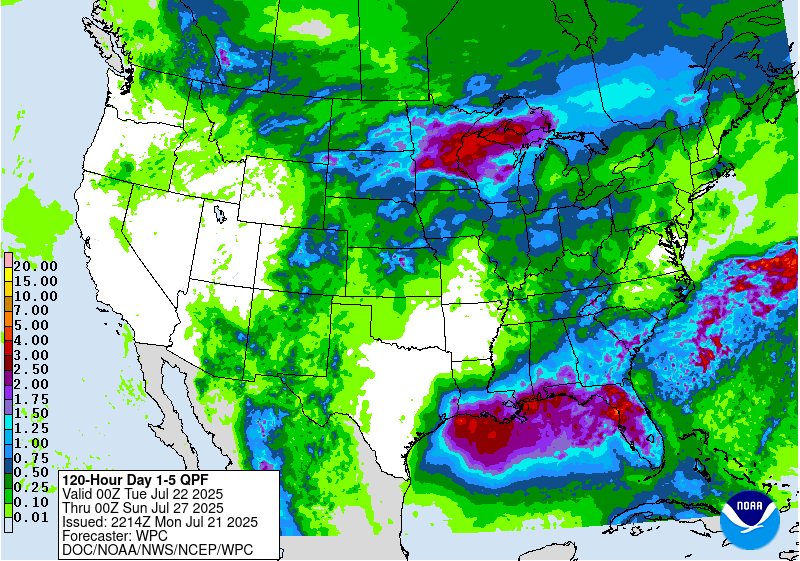
Wednesday through Saturday, a frontal boundary will move through, forcing the tropical moisture in our area up. This will result in higher rain chances throughout the day. On days where rain occurs in the early afternoon or before, the rain will stop the high temperatures from reaching too far into the 90s. If not, expect highs in the mid to upper 90s, declining into the low to mid 90s as the week goes on. Due to the tropical characteristics of this system, there could be some wind to provide further relief, especially on Friday. Chances of rain are about 50/50 on Wednesday, but will increase from there the rest of the week. Most of the area will get between 0.5″ and 1.5″ from now until Saturday evening, although locally higher amounts are possible in thunderstorms. Given the recent rainfall, there is something of a flooding risk in areas that get the heavier rainfall. The Weather Prediction Center has put out a Marginal risk (threat level one out of four) for Wednesday, Thursday, and Friday, primarily for areas near the Gulf Coast. The below map shows expected precipitation for the next 5 days.
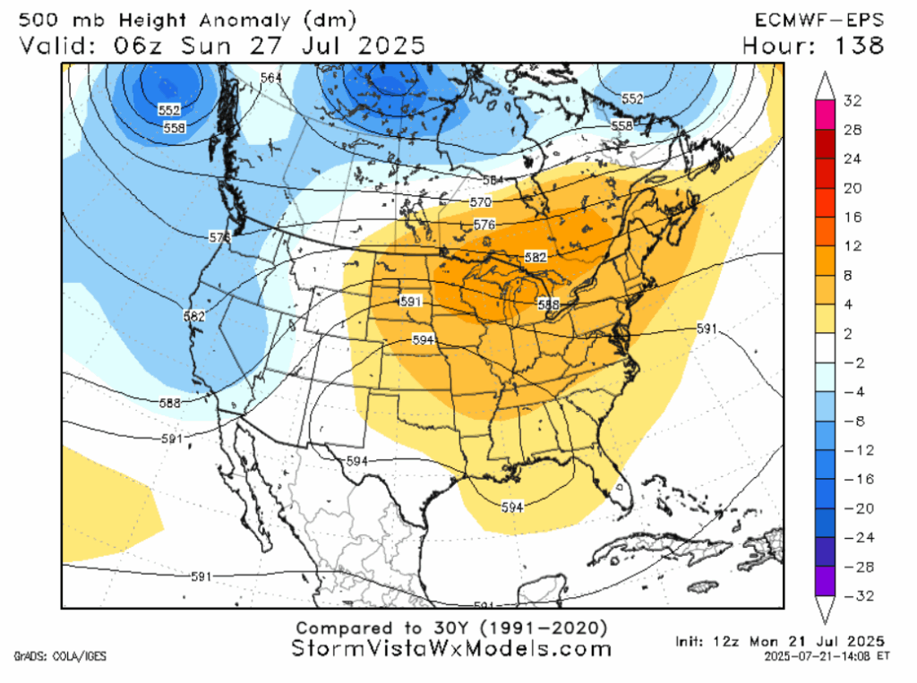
NEXT WEEK
After this system moves though, a ridge will return to our area, paving the way for a return to more typical summer-like conditions. Broad southerly flow will keep temperatures above average, with many days in the mid 90s, especially early in the week. Wind coming up from the Gulf will result in a chance of an afternoon thunderstorm every day, but the ridge will ensure some clear days sprinkled throughout the week for any given location.
REGIONAL DAY-TO-DAY FORECAST
Today: Mostly sunny. Highs up to 100. Humid. Prolonged outdoor activity may result in heat-related illness. Winds light and variable.
Tonight: Mostly clear. Lows in the high 70s.
Wednesday: Partly cloudy, chance of rain and thunder increasing throughout the day. Highs in the high 90s, except lower in areas that get early afternoon rain. Humid. Prolonged outdoor activity may result in heat-related illness. Chance of rain 50%. Lows in the high 70s.
Thursday: Partly cloudy, chance of thunderstorms. Highs in the mid 90s, except lower in areas that get early afternoon rain. Chance of rain 60%. Lows in the high 70s.
Friday: Mostly cloudy, rain and thunderstorms likely. Highs up to the mid 90s, except lower in areas that get early afternoon rain. Winds 5 to 10 mph. Chance of rain 70%. Lows in the high 70s.
Saturday: Partly cloudy, chance of thunderstorms. Highs in the low 90s, except lower in areas that get early afternoon rain. Chance of rain 60%. Lows in the mid 70s.
Sunday: Partly cloudy, chance of an afternoon thunderstorm. Highs in the mid 90s. Chance of rain 40%. Lows in the low 70s.
Monday: Partly cloudy, chance of an afternoon thunderstorm. Highs in the mid 90s. Chance of rain 30%. Lows in the low 70s.
Tuesday: Partly cloudy, chance of an afternoon thunderstorm. Highs in the low 90s. Chance of rain 30%. Lows in the low 70s.
Wednesday: Partly cloudy, chance of an afternoon thunderstorm. Highs in the low 90s. Chance of rain 40%. Lows in the low 70s.
Thursday: Partly cloudy, chance of an afternoon thunderstorm. Highs in the low 90s. Chance of rain 40%. Lows in the low 70s.


