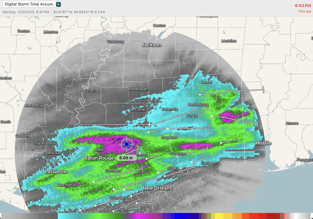
As expected, we’ve had some soaking downpours today. The rain has really been coming down from Baton Rouge through Slidell and Gulfport, including areas along the Mississippi coast. The heavier band has filled in across almost all of Mississippi, and as of this post the main batch is sliding into Alabama and slowly moving away from our area.
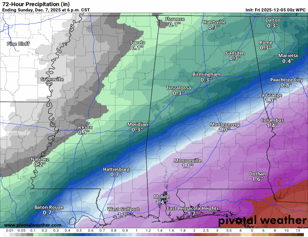
Below, the image on the left shows storm-total rainfall so far. Some of the highest amounts are just north and east of Baton Rouge, where a few spots have already picked up around 6 inches of rain. The image on the right is the WPC forecast for additional rainfall through Sunday, giving you an idea of how much more we could see before this finally wraps up.
Overall Setup
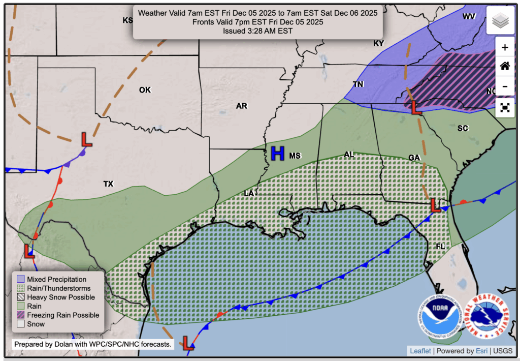
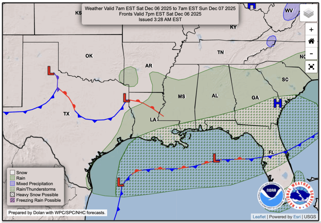
The coastal low along the northern Gulf, and the front attached to it, is responsible for all of this rain we’re seeing now, and the rain through the weekend. Friday’s surface chart shows the low sitting near the Gulf Coast with a broad area of rain and a few storms in our area. By Saturday, the low slides east, but the front stalls out and becomes stationary, which keeps some rain hanging around through the day, mainly near the coast. Conditions improve a little by Sunday as the system finally starts to pull away.

Tonight’s Forecast
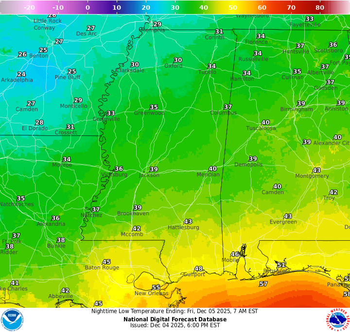
Tonight, the main batch of rain will move out of the area, but a few scattered showers will still linger at times. Lows will drop into the lower to mid 40s, with slightly warmer temperatures closer to the coast. Clouds will hang around, so it’ll stay damp and cool overnight.
Tomorrow’s Forecast: Friday, December 5
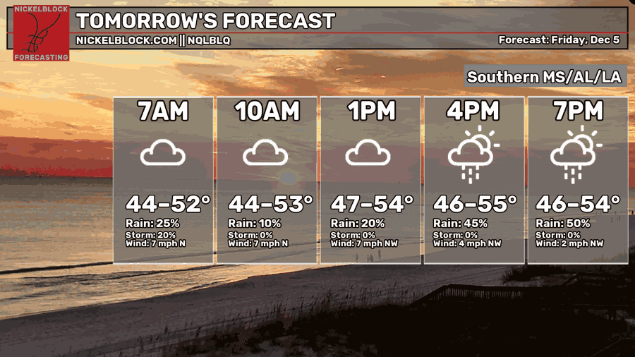
Friday looks to start off mostly cloudy and cool with just a small chance of a sprinkle early on. Through the afternoon, a more organized band of showers develops west to east across the region. Those showers become a bit more widespread between mid-afternoon and early evening. Highs will reach the low to mid 50s. Ensure you have the umbrella packed for after school and work!
Weekend Forecast: Saturday 12/6 & Sunday 12/7
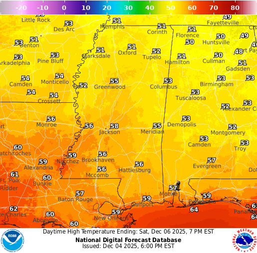
Saturday stays mostly cloudy and cool, with that stalled boundary still close by. Light rain is likely through the morning and midday, before the band slowly sags south and offshore by evening. Highs top out in the mid 50s.
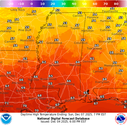
Sunday looks a little better, but not completely dry. We warm into the mid 60s with mostly cloudy skies and a slight chance for a few passing showers, especially in the afternoon and evening from central Mississippi and Alabama down toward the coast. Most of the day should be fine, but keep the rain gear nearby if you have outdoor plans.
Extended Local Outlook
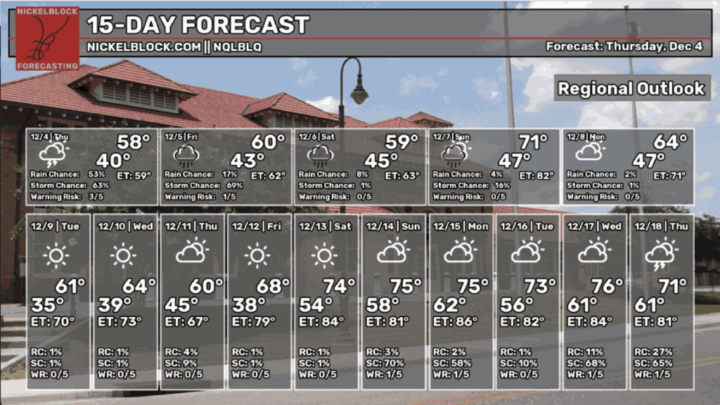
The 15-Day forecast shows highs run in the upper 50s to mid 60s early in the week, then climb back into the 70s later on. Overnight lows stay on the chilly side, especially Tuesday and Wednesday mornings when many spots dip into the 30s.
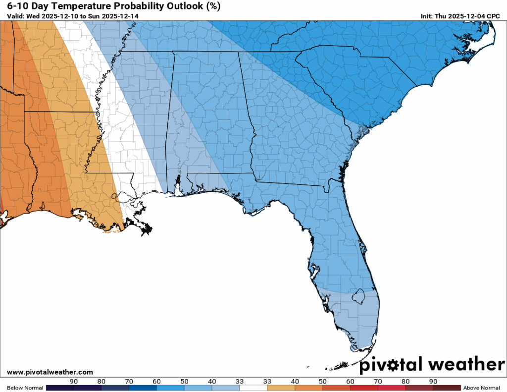
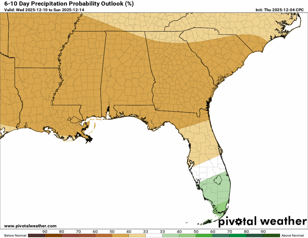
In the 6-10 day CPC outlook, we sit right on the edge between below normal and above normal temperatures, with the warmer side slowly trying to creep in late in the period. That lines up well with what we’ve been expecting from the probability charts we’ve been showing you recently about a “warmup” mid-December.

REGIONAL DAY TO DAY FORECAST
Tonight: Rain, mainly before 11 p.m. Lows in the lower 40s. Northeast wind around 5 mph becoming calm in the evening. Chance of rain 80 percent.
Friday: Rain, mainly after 1 p.m. Cloudy. Highs in the lower 50s. North wind around 5 mph becoming calm in the afternoon. Chance of rain 80 percent.
Friday Night: Rain likely. Cloudy. Lows in the mid 40s. Calm wind. Chance of rain 60 percent.
Saturday: Scattered showers possible. Cloudy. Highs in the mid 50s. Calm wind becoming east-northeast around 5 mph. Chance of rain 70 percent.
Saturday Night: A chance of rain. Mostly cloudy. Lows in the upper 40s. Calm wind. Chance of rain 30 percent.
Sunday: A chance of scattered rain. Mostly cloudy. Highs in the mid 60s. Calm wind becoming north-northwest around 5 mph. Chance of rain 50 percent.
Sunday Night: A chance of rain before midnight. Mostly cloudy. Lows in the mid 40s. North wind around 5 mph. Chance of rain 30 percent.
Monday: Mostly sunny. Highs in the mid 50s. North wind 5 to 10 mph.
Monday Night: Mostly clear. Lows in the mid 30s.
Tuesday: Sunny. Highs in the upper 50s.
Tuesday Night: Mostly clear. Lows in the mid 30s.
Wednesday: Sunny. Highs in the mid 60s.
Wednesday Night: A slight chance of rain. Partly cloudy. Lows in the mid 40s. Chance of rain 20 percent.
Thursday: Mostly sunny. Highs in the mid 60s.


