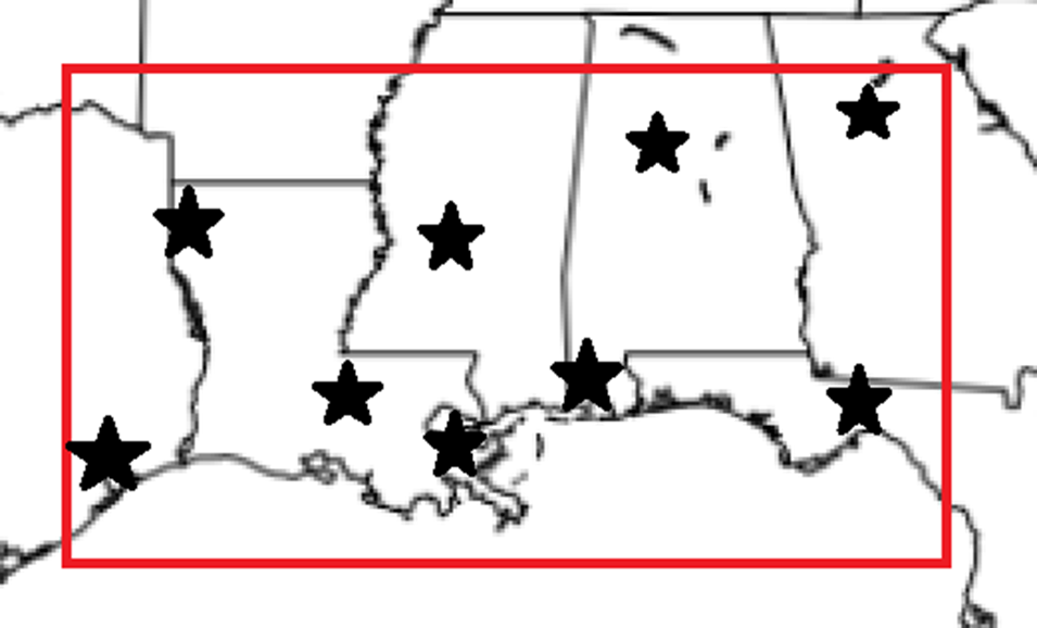
Welcome to the first of many regional forecasts this Summer. It’s been a few years since we’ve done these, but a reminder that these regional outlooks cover a big chunk of the Gulf / Southeast. We are going to try to give you guys a view on eh forecast for any travel plans or vacations you might be taking this Summer. And we will cover the region inside the red box with specific city forecasts for the cities that are starred on the map (a few of which are also in our local area).
While high pressure is the name of the game this weekend, as we move through next week that is going to change. The ridge is going to buckle a bit, and then we flip the pattern on its head. That means a change – for some folks – from dry to wet. And for others it simply means from mild to hot.
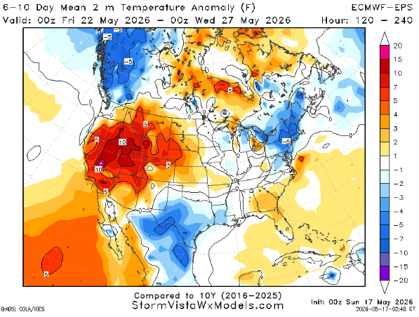
The composite maps below do a good job at showing how the subtle change in the mid-levels is doing a big number to our weather across the region.
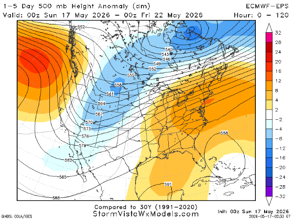
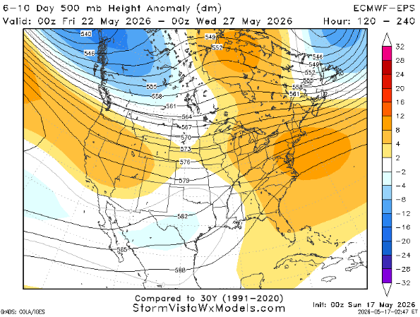
Notice how a good part of the area is under the orangish color on the map on the left. And then on the right, only part of region is anymore.
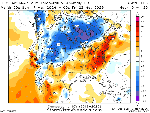
That moves us from warmer than normal and drier (below, left) to closer to normal temperatures for some, but still warmer than normal for others (below, right).
The shift if aprtly due to the surge of Gulf moisture ahead of the front and then the showers and storms that the front will produce starting on Tuesday/Wednesday of this week… that stick around through the weekend and maybe into next week.
In fact, for the rest of this week we have a really uniquely textbook weather pattern setup for rain.
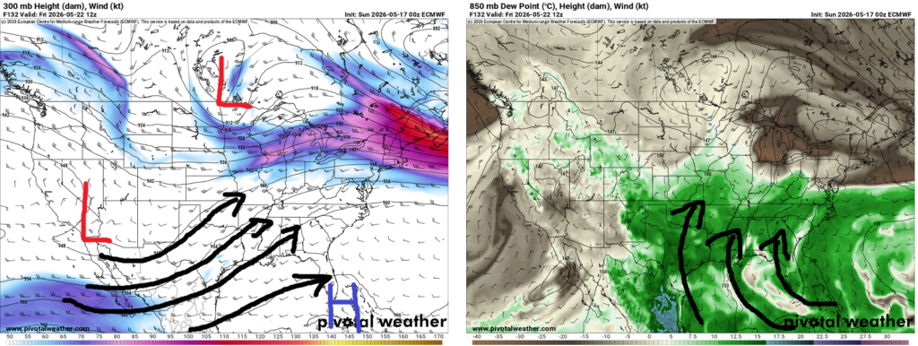
Aloft, at 300mb, we have a southwest to northeast flow around a ridge with divergence. Then down at 850mb we have a southerly flow off the Gulf with ton of available moisture being pulled in from -deep- in the tropics.
This combination is basically like having a fire in your fireplace, with a strong wind outside pulling air out of the chimney. That is always the best way to keep a fire going because you’re pulling in the air the fire needs to keep going and you’re pulling the smoke out of the chimney.
Kinda neat! And, in this case, rainy for most of us.
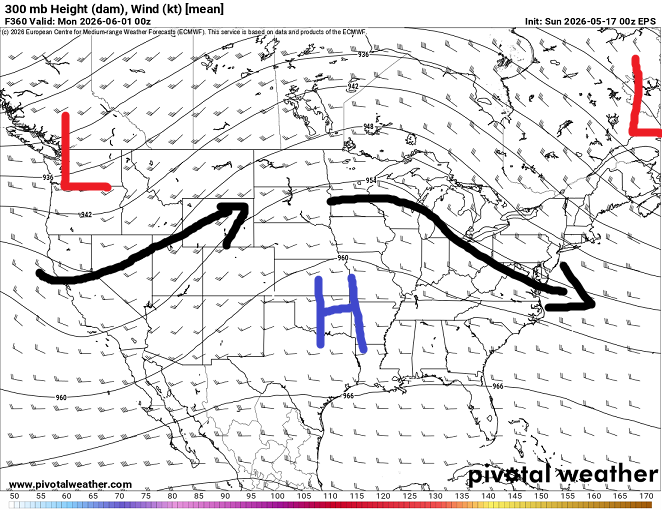
When does this pattern break down? June 1st by the looks of it.
3-DAY TRAVEL FORECAST
AIRPORTS
KIAH / KHOU (Houston) – Afternoon showers and storms possible each day. Some intermittent flight delays are possible for lightning. But most flights between 5a and 12p should be not be impacted by weather.
KSHV (Shreveport) – Afternoon showers and storms possible each day. A better shot for rain arrives Tuesday. Some intermittent flight delays are possible for lightning.
KBTR (Baton Rouge) – Outside shot for morning fog Sunday and Monday. Any morning flights could be delayed until the fog clears. Afternoon showers and storms possible each day. Some intermittent flight delays are possible for lightning. But most flights between 9a and 2p should be not be impacted by weather.
KMSY (New Orleans) – Chance for morning fog each day. Afternoon showers and storms also possible. Intermittent flight delays possible for each. But most flights between 9a and 2p should be not be impacted by weather.
KJAN (Jackson) – Outside shot for morning fog Sunday and Monday. Any morning flights could be delayed until the fog clears. Afternoon showers and storms possible each day. Some intermittent flight delays are possible for lightning. But most flights between 9a and 2p should be not be impacted by weather.
KMOB (Mobile) – Chance for morning fog each day. Afternoon showers and storms also possible. Intermittent flight delays possible for each. But most flights between 9a and 2p should be not be impacted by weather.
KBMH (Birmingham) – No weather related issues anticipated through Tuesday.
KTLH (Tallahassee) – Chance for morning fog each day. Low-end chance for afternoon showers and storms possible each day. Some intermittent flight delays are possible for lightning. But most flights between 10a and 4p should be not be impacted by weather.
KATL (Atlanta) – Some showers and storms possible today. Intermittent weather delays possible for some flights due to lightning. Aside form that, no weather related issues anticipated through Tuesday.
HIGHWAYS
I-10
Not bad. Hit and miss showers and storms from Houston to Tallahassee possible each day. Be prepared for brief rounds of heavy rain, lightning and gusty wind. This may lead to ponding on the highway, so slow down as you drive through any storms.
I-20
Lookout for showers and storm between Shreveport and Jackson. Things should be drier east of Jackson through Atlanta.
I-49
Mostly dry today and tomorrow. Northern sections of I-49 may have some storms to deal with by Tuesday. This would feature brief heavy rain and lightning. Brief flooding across the roads may be possible. Prepare for some slow downs and delays.
I-55 & I-59
Dry through Monday. Tuesday night there way be some rain for northern sections of I-55. Lookout for water on the roads and some ponding possible.
I-65
Looking good through the next three days. No widespread major concerns anticipated. A spotty shower or storm can’t be ruled out.
I-75
Same goes here, things looking good aside from a spotty storm.
CITY FORECASTS
Houston, TX
Today – Warm, breezy, and mostly cloudy with highs near 89. A few spotty afternoon showers are possible, but many areas stay dry. Southeast winds 15 to 20 mph with gusts up to 25 mph.
Monday – Another warm and humid day with mostly cloudy skies and scattered afternoon showers and thunderstorms developing after lunchtime. High near 88 with gusty southeast winds continuing. Rain chance: 40%.
Tuesday – Mostly cloudy and muggy with highs near 89. A few afternoon storms may develop, but the better chance for widespread showers and thunderstorms arrives Tuesday night. Rain chance during the day: 30%.
Shreveport, LA
Today – A warm and breezy day ahead with a mix of clouds and sunshine. A few isolated showers or thunderstorms are possible, but most spots will stay dry. Highs climb to around 90 with south winds gusting up to 25 mph.
Monday – Very warm and humid with mostly cloudy skies hanging around through the day. Highs once again reach near 90 with a steady south breeze continuing. A stray evening storm can’t be ruled out overnight.
Tuesday – Storm chances increase as we head deeper into the week. Expect a mix of sun and clouds early, followed by scattered showers and thunderstorms developing during the afternoon and evening. High near 90. Rain chance: 60% during the day and 50% Tuesday night.
Baton Rouge, LA
Today – Expect a warm and somewhat unsettled afternoon with scattered showers and thunderstorms developing, especially during the mid to late afternoon hours. Some storms could briefly produce heavy downpours. Highs reach the mid 80s with a light south breeze. Rain chance: 60%.
Monday – A mix of clouds and sunshine continues with warm and humid conditions in place. A few afternoon thunderstorms may pop up after lunchtime, but much of the day will stay dry. High near 87 with southeast winds gusting at times to 20 mph. Rain chance: 30%.
Tuesday – Storm chances increase again with scattered showers and thunderstorms likely during the afternoon and evening. Partly sunny skies early will give way to a more active weather pattern later in the day. High near 87. Rain chance: 70%.
New Orleans, LA
Today – Warm and humid conditions continue with a mix of sun and clouds. A few scattered thunderstorms may develop during the afternoon, though many locations will stay dry. High near 84 with southeast winds around 10 to 15 mph. Rain chance: 30%.
Monday – Another summer-like day with partly sunny skies and only isolated afternoon thunderstorms expected. Highs climb into the mid 80s with a light southeast breeze continuing. Rain chance: 20%.
Tuesday – Storm coverage becomes a bit more widespread with scattered showers and thunderstorms developing by late morning and continuing into the afternoon. High near 86 with partly sunny skies outside of storms. Rain chance: 50%.
Jackson, MS
Today – A warm and mostly sunny day is ahead with highs reaching the upper 80s. A few isolated showers or thunderstorms may develop late this afternoon, but most areas stay dry. Light south winds continue through the day. Rain chance: 30%.
Monday – Partly sunny, warm, and humid with only a slight chance for a pop-up afternoon thunderstorm. Highs climb near 88 with occasional gusts up to 20 mph. Rain chance: 20%.
Tuesday – A more active afternoon pattern develops with scattered showers and thunderstorms expected after lunchtime. Some storms could produce locally heavier rainfall. High near 89 with partly sunny skies outside of storms. Rain chance: 50%.
Birmingham, AL
Today – A beautiful day ahead with plenty of sunshine and warm temperatures topping out near 88. Light south winds will keep things feeling comfortable through the afternoon.
Monday – More of the same to start the workweek with mostly sunny skies and highs again reaching the upper 80s. A light south breeze may gust at times up to 20 mph.
Tuesday – A mix of sun and clouds develops, but it stays warm with highs near 88. Most of the day looks dry, though a few late-night showers or thunderstorms could begin developing after midnight.
Mobile, AL
Today – Sunshine and warm temperatures make for a pleasant afternoon with highs reaching the mid 80s. Light south winds continue through the day.
Monday – A warm and slightly more humid day ahead with a mix of clouds and sunshine. Patchy morning fog will give way to improving conditions, and a few isolated thunderstorms could develop late in the afternoon. High near 87. Rain chance: 20%.
Tuesday – Mostly sunny and warm with highs pushing the upper 80s. Overall, another fairly quiet day weather-wise with light south winds continuing.
Tallahassee, FL
Today – Summer-like heat settles in with plenty of sunshine and highs climbing into the lower 90s. Light south winds will keep conditions warm but fairly quiet overall.
Monday – Another hot and sunny day ahead with afternoon temperatures reaching near 92. Winds stay light out of the east-southeast, making for a calm start to the week.
Tuesday – Very warm conditions continue with mostly sunny skies and highs once again in the lower 90s. Overall, a dry and quiet weather pattern remains in place.
Atlanta, GA
Today – Warm and mostly sunny conditions continue, but a few afternoon and evening thunderstorms may develop after 2pm. Not everyone will see rain, though any storm could briefly produce heavy downpours. High near 88 with a light southeast breeze. Rain chance: 40%.
Monday – Sunshine returns in full force with warm temperatures climbing back into the upper 80s. A pleasant southeast breeze continues through the day with dry conditions expected.
Tuesday – Partly sunny and warm with highs once again near 88. Overall, a fairly quiet weather pattern remains in place through midweek.


