Another day and another severe weather outbreak in the Plains. What a surprise. It’s mid-May. While it is quiet in the deep south currently, a soggy pattern will likely impact the region starting Wednesday and peaking this weekend. Thankfully the threat for organized severe weather appears low.
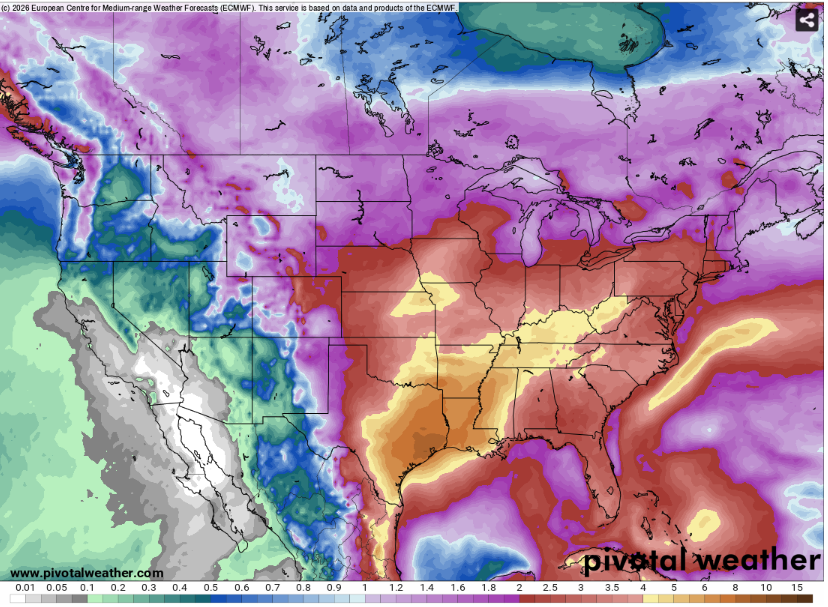
A cold front will drift south into the region and stall allowing for repeated rounds of thunderstorms. This system will bring beneficial rainfall and then some. The humidity meanwhile will go nowhere as gulf moisture hangs out through the period.
Although the humidity and rain may be unpleasant it is a lot better ice and snow.

TONIGHT
It will be a warm and humid night with light winds out of the south. Some fog may occur in river valleys or low living areas so watch out for that (and the surprise deer) if you are out driving at night.
Since there will not forcing for storms, no precipitation is expected. Enjoy it while it lasts.
Temperatures will bottom out in the low 70s. Since the dewpoints will be high this will keep the temperature from falling any further.
TOMORROW
It will be a hot one and feel even worse.
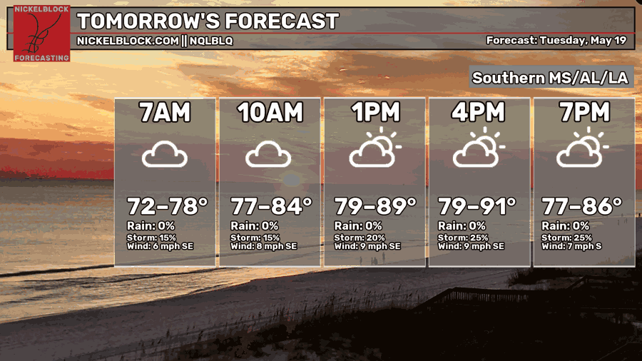
The jet stream will stay far to the north keeping sinking motion in place over the area. This will allow heat to build with heat index values potential exceeding 100 degrees.
As always, there will be chance for afternoon and evening convection but this will not be very impactful (unless your home gets hit by a rogue bolt of lightning).
A cold front will slowly approach the area from the northwest. But for Tuesday it will stay a bit to far to be impactful.
Try to find an excuse to stay in a place with AC and avoid intense, outdoor exercise during the peak heating time. Make sure to drink plenty of water and take breaks if you must be outside.

DAY AFTER TOMORROW
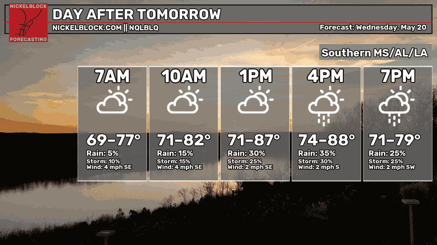
Rain Chances will increase as we get into Wednesday.
The heat and humidity will stay in place.
This is due to the position of the jet stream.
Since the faster winds in the upper atmosphere will be far to the north of the region, storms will have trouble becoming organized. This means that the storms will rain in there own updrafts and therefore kill themselves in the process. All together, severe weather chances will thankfully be very low.
The storms will be very slow moving and relatively short lived.

EXTENDED OUTLOOK
Rain chances will increase late week and into the weekend.
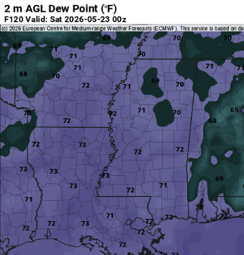
The dewpoints will be in the low 70s. This means that an excessive amount of moisture is present and therefore the potential for high rainfall totals.
The afirmentioned front will linger around the area which will provide the convergence needed to form thunderstorms. Severe weather chances may increase as well.
The rainy pattern may last for the foreseeable future with long range models continuing to show large amounts of rain.
Temperatures may cool slightly from compared to this week due to widespread rain and cloud cover but the humidity will be here to stay.
This will good news for busting the drought but bad news for those hoping for time outside.
DAY-BY-DAY FORECAST
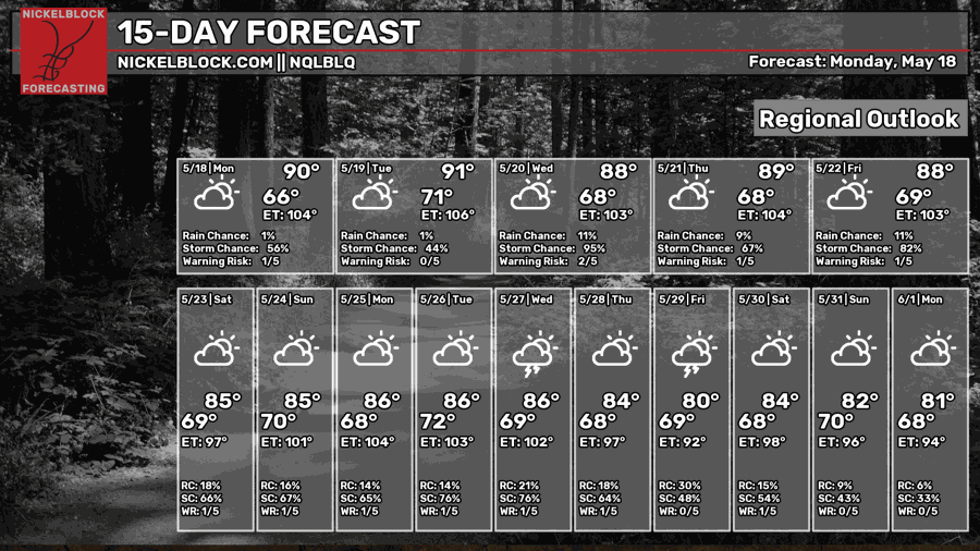
Tonight- calm and humid with fog possible. lows in the lower 70s.
Tomorrow- Humid and gross. Highs around 90s. Isolated thunderstorms possible in the afternoon. Cumulus clouds will increase into the afternoon.
Tomorrow night- Mostly cloud with lows around 70. Mostly cloudy and calm.
Wednesday- Chance of afternoon thunderstorms. Highs in the upper 80s. Still humid and gross. Light south wind.
Wednesday night- Calm and partly. Low around 70.
Thursday- Higher chances of thunderstorms. Partly sunny and humid. Light south wind. Highs in the upper 80s.
Thursday Night- Calm wind. Lower chance of thunderstorms. Lows around 70 and mostly cloudy.
Friday- Widespread showers and storms. Light south wind with mostly cloudy skies. Cooler highs (mid 80s).
Friday Night- Chance of thunderstorms. Calm wind and mostly cloudy. Low in the low 70s.
Saturday- Widespread showers and thunderstorms (again). High in the mid 80s due to widespread cloud cover.
Saturday Night- Lower chance for showers and thunderstorms. Mostly cloudy with lows around 70.
Sunday- Another day with many showers and storms. Highs in the mid 80s with mostly cloudy skies.
Sunday night- Slight chance of showers and storms. Mostly cloudy with lows in the lower 70s.


