What a surprise. It’s May and there are many chances of rain for the majority of the region.
A fairly textbook pattern for heavy rain exists for much of south. The gulf waters are very warm and strong moisture advection is in place due to southerly low level winds. Minimal capping and very high precipitable water values (the amount of water in vertical column of the atmosphere) will lead to plenty of fuel for thunderstorms.
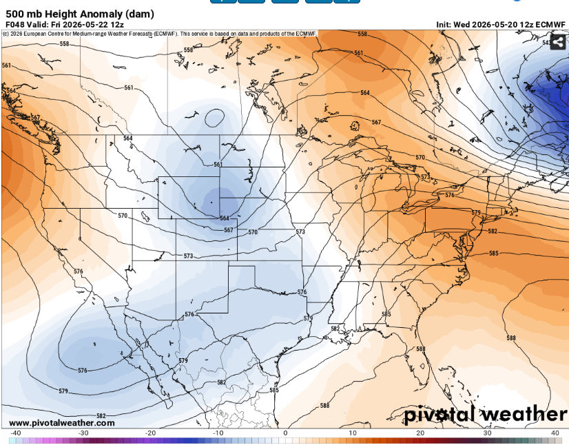
Aloft, we have a ridge in the eastern CONUS and a trough over the southwest. This will keep winds out of the southwest over the region which is favorable for widespread convection.
As we move into the longer ranges, the ridge will slide back to the west and the subtropical jet may work its way underneath.
All this is to say that the rainy weather will probably stick around for awhile
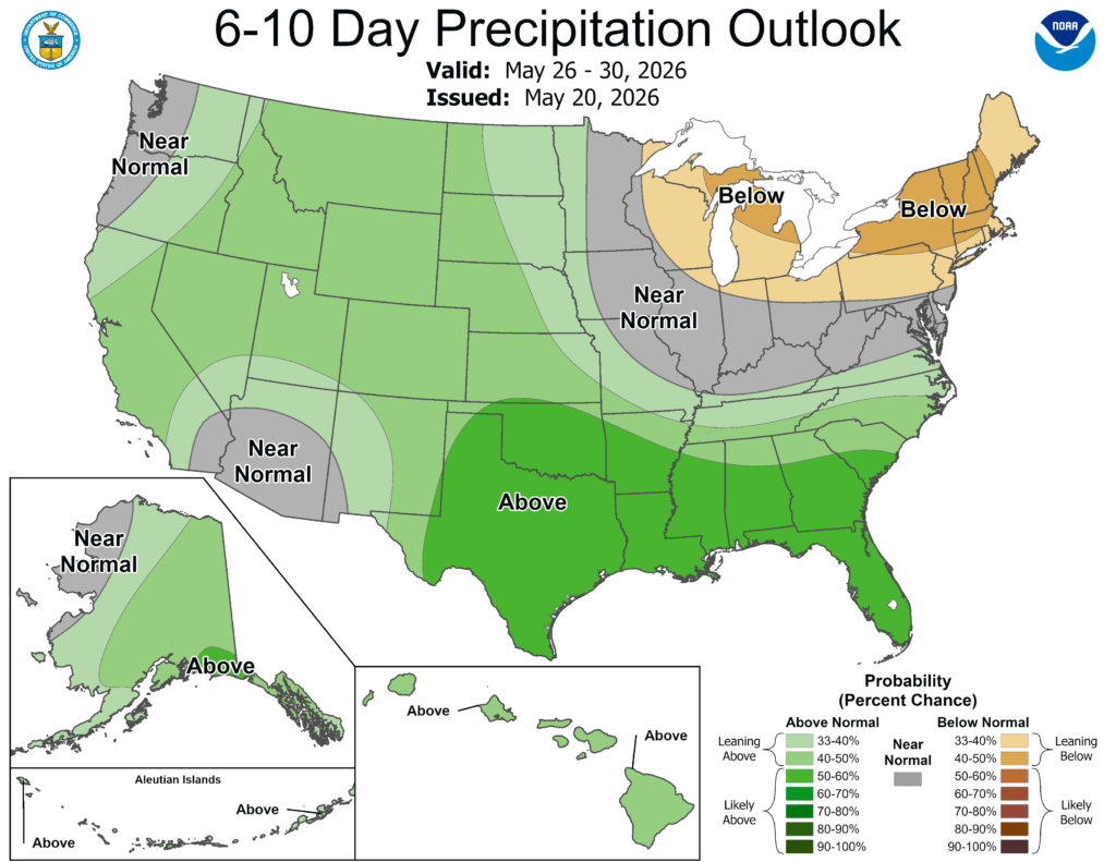
Some guidance indicates that a series of cutoff lows will traverse along the coast bringing significant rainfall accumulation. This will definitely put a big dent in the ongoing drought and may resolve it entirely.
The good news about this pattern is that the severe weather potential is currently expected to be very low. These storms will likely be of the pulse variety which means that they will be slow moving, produce little more than heavy rain and frequent lightning. We can’t entirely rule out the potential for a brief tornado or wet microburst, but overall this activity should be fairly benign.
As usual, watch out for ponding on roadways. Due to the number of storms that are forecast to occur, flooding may eventually become a concern along rivers or in low lying areas but it is too far out to know for certain.
3-DAY TRAVEL FORECAST
Houston (KHOU and KIAH) – On and off showers and storms. There may some delays for lightning or microbursts but thankfully the severe weather treat will be low.
Shreveport (KSHV) – Flights tonight and tomorrow morning should be fine but thunderstorm chances ramp up Thursday afternoon. Lightning and heavy rain will be the main threats.
Baton Rouge (KBTR) – Numerous showers and thunderstorms. Lightning may delay several flights. There will be some dry time but it won’t last super long.
New Orleans (KMSY) – Chances for showers and thunderstorms. Lightning will be in the area throughout the period but it may not always be directly over the airport. Some fog is also possible.
Jackson (KJAN) – Yet another airport that may be affected by thunderstorms. Fog is also possible tonight. Tomorrow morning will likely be the quietest time.
Mobile (KMOB) – Patchy fog may be possible tonight. There is a chance for some midday storms but most of the day looks good.
Birmingham (KBMH) – Scattered showers and thunderstorms. There may also be some fog around sunrise.
Tallahassee (KTLH) – A very small chance of a mid-afternoon thunderstorm but otherwise there should be no issues.
Atlanta (KATL) – Off and on showers and thunderstorms. Lightning may cause a few delays but severe weather is not expected.
Interstates
I-10 – Clear overnight. Thunderstorms likely from Houston to the Mississippi but clear to the east. Be mindful of ponding on roadways and the associated hydroplaning risk.
I-20 – Thunderstorms weaken during the evening. Widespread in LA with coverage diminishing as you reach AL.
I-49 – Midday storms develop across southwest LA and move north, weakening by sunset.
I-55/I-59 – Scattered afternoon storms becoming more widespread by evening.
I-65 – Some rain during the overnight hours but most convection should stay to the west for tomorrow.
I-75 – Some isolated thunderstorms are possible but most of the route should be dry.
City Forecasts
Houston, Texas
Tonight- Humid with light winds. Mostly cloudy with a low of 73. There is some potential for a thunderstorm or two.
Tomorrow- Widespread showers and thunderstorms, peaking during the midday hours. Mostly cloudy skies with highs in the low 80s.
Friday- Another day of widespread showers and storms. Highs in the mid 80s. Most of the day will be cloudy but there will be some pockets of blue sky.
Shreveport, LA
Tonight- Mostly cloud with a calm wind. Lows in the upper 60s with no precipitation expected
Tomorrow- Increasing clouds as thunderstorms develop throughout the day. Highs in the low 80s.
Friday- More storms but not a complete washout. High in the mid 80s with gross humidity.
Baton Rouge, LA
Tonight- low in low 70s. Cloudy and damp with a chance of thunderstorms.
Tomorrow- Scattered thunderstorms. Most of the day will be cloudy but you may see some sun. High in the mid 80s
Friday- Rinse and repeat. Another chance of thunderstorms with high humidity. Highs in the low to mid 80s.
New Orleans, LA
Tonight- weakening showers and thunderstorms. Lows in the mid 70s with a chance for some fog.
Tomorrow- A chance for afternoon thunderstorms. Increasing clouds with highs in the mid 80s.
Friday- Another day of afternoon storms. Highs in the mid 80s with increasing clouds.
Jackson, MS
Tonight- Cloudy with a low in the upper 60s. A slight for a thunderstorm in am hours.
Tomorrow- Afternoon thunderstorms likely with highs in the mid 80s. Clouds will slowly build as the day goes on.
Friday- Numerous thunderstorms with highs in the low 80s. It won’t rain all day but it will rain a lot.
Birmingham, AL
Tonight- Scattered showers and storms. Cloudy with lows in the upper 60s and light winds.
Tomorrow- Showers and thunderstorms becoming greater in coverage by afternoon. Partly with a high in the mid 80s.
Friday- Widespread thunderstorms with mostly cloudy skies. High in the low 80s with a steady southerly breeze.
Mobile, AL
Tonight- Mostly cloudy and damp with a low around 73.
Tomorrow- Chance of midday thunderstorms. Decreasing clouds in the afternoon with highs in the upper 80s.
Friday- Scattered showers and storms growing in coverage by afternoon. Increasing clouds with highs in the mid 80s.
Tallahassee, FL
Tonight- Low around 70 with a partly cloudy sky. Dry with minimal winds.
Tomorrow- Mostly sunny with a high in the low 90s. A mid afternoon thunderstorm cannot be ruled out.
Friday- Mostly sunny with a high in the low 90s and a weak south breeze. Dry.
Atlanta, GA
Tonight- Scattered thunderstorms with mostly cloudy skies. Low in the upper 60s.
Tomorrow- Mostly cloudy with an increasing chance for storms into the afternoon hours. Highs in the mid 80s.
Friday- Increasing clouds as thunderstorms grow more widespread. Highs in the mid 80s.


