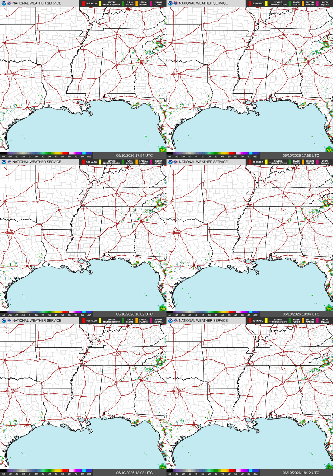
The big story across the South today isn’t rain or storms; it’s the heat. Summer-like temperatures continue to build across the region, with many cities climbing well into the 90s this afternoon.
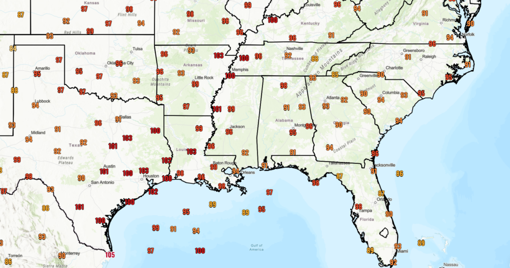
Taking a look at the current heat index values for cities across the South, we see very warm “real-feel” temperatures that can quickly turn dangerous. Be sure to drink water and stay cool, especially when exercising or being outdoors.
Current conditions are hot, with no rainfall expected in the region. Temperatures are climbing well into the upper 80s and lower 90s this afternoon, but thanks to the humidity, it’ll feel more like the mid-to-upper 90s in many locations, as the chart above shows.
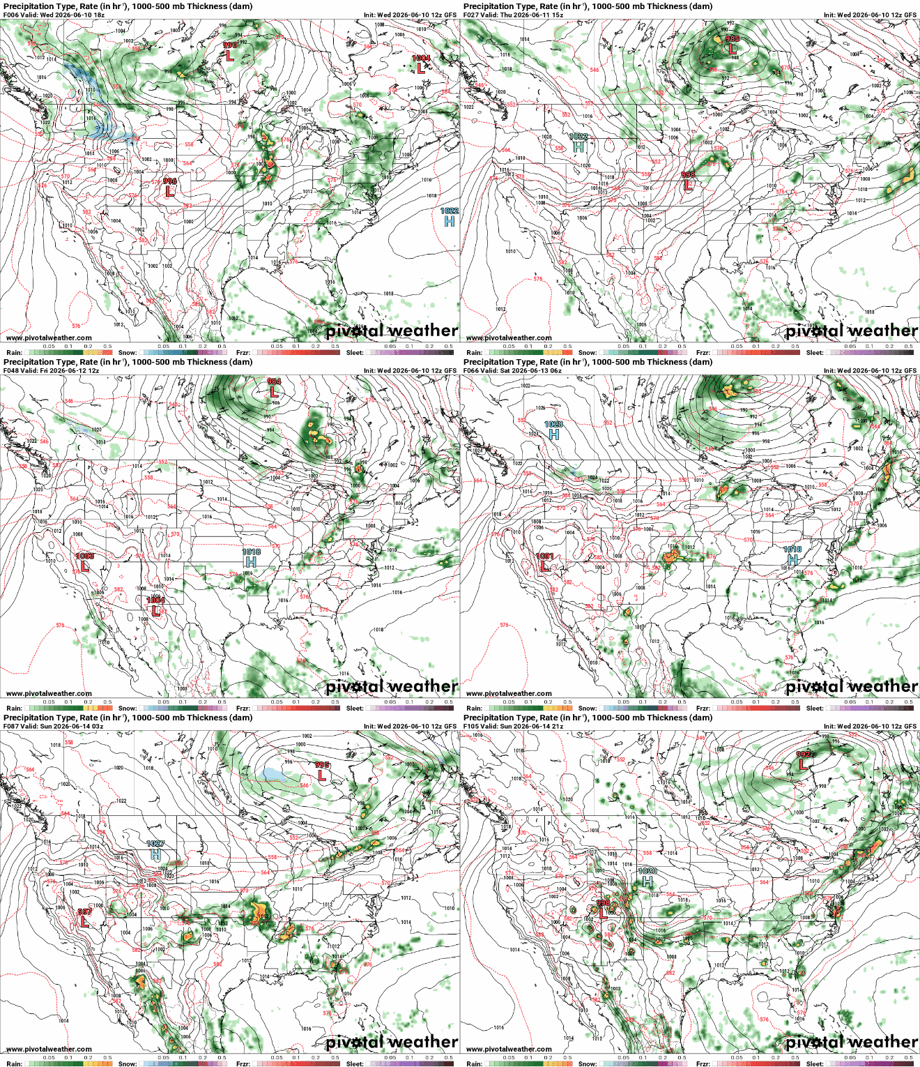
Looking into the next 5 days, a similar pattern appears in our GFS model, indicating a high-pressure area from the Appalachians moving further south towards the Gulf, keeping our area hot and dry for the next few days. We can expect afternoon storms to move in starting this Saturday as the high-pressure system continues its trip south, and we swing back into the normal summer structure.
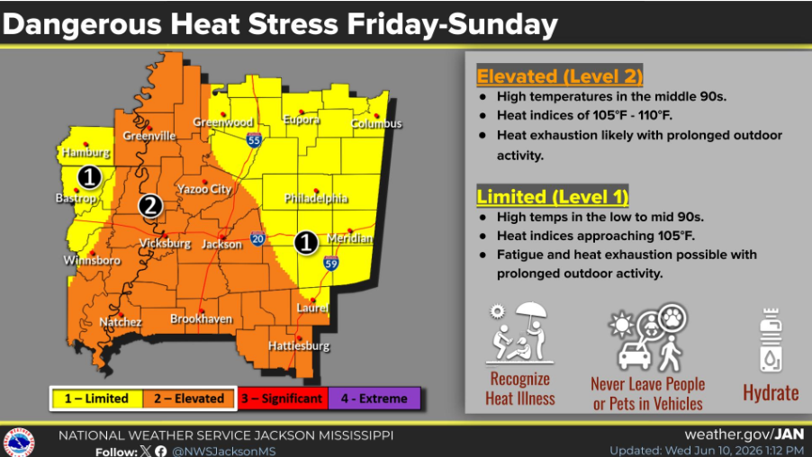
Also something to keep on our radar are dangerous heat warnings which are forecasted for this weekend in the Western/Central MS area surrounding Jackson. This means the high temperatures combined with the humidity will increase the chance for heat-related illnesses, especially in the orange area where heat indices of 100-105 degrees are expected. Take special precautions if you are in the selected area or nearby, as heat doesn’t stop at county lines.
3-Day Travel Forecast
AIRPORTS
KIAH / KHOU (Houston) – No delays expected for the next two days. Delays are possible Saturday evening as storms move in.
KSHV (Shreveport) – Low delay risk due to scattered afternoon storms until Saturday afternoon.
KBTR (Baton Rouge) – Occasional brief delays possible, mostly with the afternoon thunderstorms expected Saturday.
KMSY (New Orleans) – Moderate chance of daily afternoon storm delays from coastal storms.
KJAN (Jackson) – Low to moderate delay risk from isolated afternoon storms.
KMOB (Mobile) – Some brief afternoon delays possible, otherwise generally smooth operations.
KBMH (Birmingham) – Low delay risk. Only isolated afternoon storms could cause brief issues.
KTLH (Tallahassee) – Moderate daily delay risk from afternoon/evening thunderstorms.
KATL (Atlanta) – Low risk of delays until Saturday afternoon when scattered thunderstorms increase delay risk.
HIGHWAYS
I-10: Hot and humid weather continues through the next three days. Expect scattered afternoon thunderstorms from eastern Texas to Florida on the weekend, with brief heavy rain possible.
I-20: Warm to hot conditions are expected across the corridor. A few afternoon thunderstorms may develop, especially from Texas to Mississippi over the weekend.
I-49: Daily chances for showers and thunderstorms will continue to increase later in the week. Some storms could produce heavy downpours and slow travel at times.
I-55 & I-59: Hot and muggy weather sticks around through the period. Scattered afternoon storms are possible, mainly across Mississippi and Louisiana.
I-65: Mostly dry and hot weather is expected along much of I-65. Only isolated afternoon thunderstorms are expected near the Gulf Coast.
I-75: Summer heat continues from Tennessee to Florida. Afternoon thunderstorms will be most common across Georgia and Florida each day.
3-Day City Forecast
Houston, TX: Thursday: Mostly sunny with a low chance of rain. High 92°F, low 78°F. Friday: Mostly sunny with a slight chance of thunderstorms. High 92°F, low 77°F. Saturday: Sunny and clear. High 93°F, low 78°F.
Shreveport, LA: Thursday: Mostly sunny and hot. High of near 95°F. Low of 77°F.
Friday: Partly cloudy with a chance of afternoon showers. High of 98°F. Low of 75°F.
Saturday: Scattered thunderstorms in the afternoon. High of 97°F. Low of 75°F.
Baton Rouge, LA: Thursday: Mostly sunny. High 93°F, low 75°F.
Friday: Partly sunny, turning to afternoon showers. High 92°F, low 75°F. Rain chance increases to 40%.
Saturday: Mostly cloudy with afternoon thunderstorms. High 93°F, low 76°F.
New Orleans, LA: Thursday: Hot and mostly sunny. High of near 90°F. Low of 78°F.
Friday: Scattered thunderstorms developing after midday. High of 90°F. Low of 79°F.
Saturday: Light afternoon rain showers with a southwest breeze. High of 91°F. Low of 79°F.
Jackson, MS: Thursday: Lots of sunshine and hot. High of near 95°F. Low of 73°F.
Friday: Partly sunny with a small chance of an afternoon shower. High of 95°F. Low of 75°F.
Saturday: Partly sunny with scattered afternoon thunderstorms developing. High of 94°F. Low of 75°F. *Heat Advisory Fri-Sat*
Birmingham, AL: Thursday: Sunny and hot, with an afternoon shower possible. High of 92°F. Low of 73°F.
Friday: Scattered afternoon thunderstorm potential. High of 93°F. Low of 73°F.
Saturday: Cloudy skies with heavy thunderstorms likely after noon. High of 91°F. Low of 72°F.
Mobile, AL: Thursday: Clear, sunny skies and hot. High of near 92°F. Low of 76°F.
Friday: Partly cloudy with scattered afternoon thunderstorms. High of 93°F. Low of 76°F.
Saturday: High humidity with widespread showers and storms. High of 93°F. Low of 75°F.
Atlanta, GA: Thursday: Clear and sunny. High of near 91°F. Low of 73°F.
Friday: Scattered afternoon thunderstorms developing. High of 92°F. Low of 74°F.
Saturday: Widespread showers and heavy storms. High of 91°F. Low of 73°F.
Tallahassee, FL: Thursday: Clear and sunny with intense heat. High of near 94°F. Low of 74°F.
Friday: Partly sunny with building humidity and dangerous heat. High of 95°F. Low of 74°F.
Saturday: Extremely hot and humid with isolated afternoon thunderstorms. High of 96°F. Low of 75°F.


