Howdy!
Happy Friday everyone! Looking out the window (NOAA) for the current weather, we can see that a lot of the region is seeing clouds, even if it is just a few in the upper levels. We can also see a boundary (cold front) in this image from the long line of clouds from Pennsylvania all the way to northeast Texas. We can also see an outflow boundary in north Texas and Oklahoma (seen by the circle-like feature of clouds flowing out of the storms present in that area).
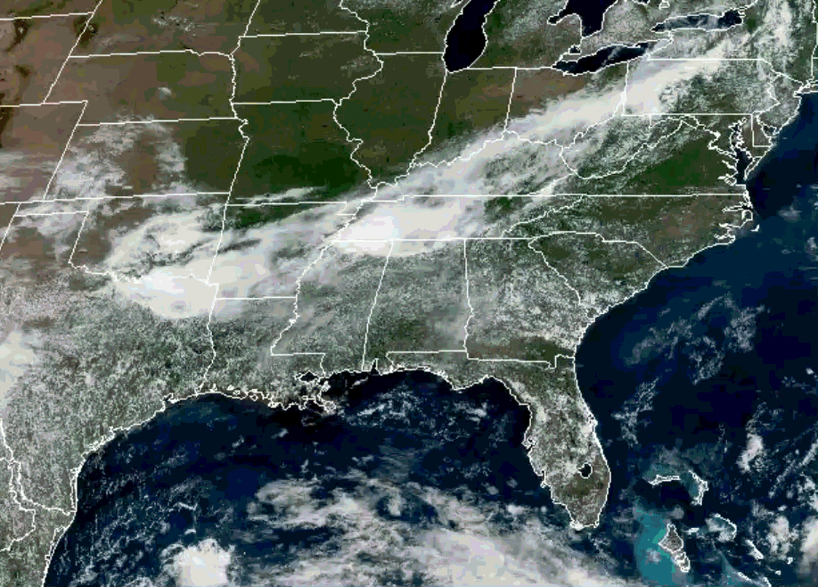
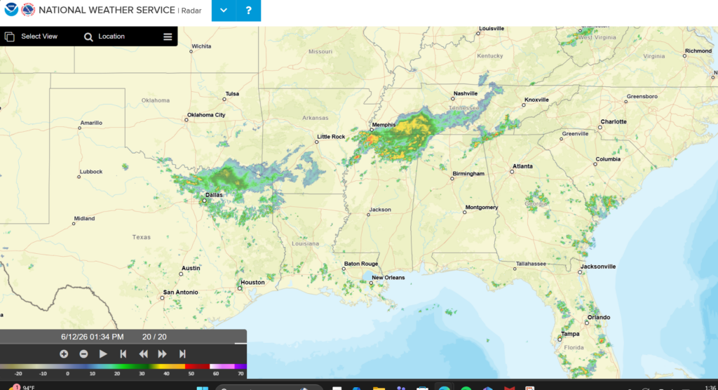
The cold front is currently triggering thunderstorms and rain in north Texas, parts of southwest Arkansas, southern Tennessee and northern Mississippi (see above on NWS radar). For the southeast United States right now, there is not much of anything going on, some showers present in southern Louisiana near the coast.
The outflow boundary has the possibility of triggering new showers and thunderstorms along it. For those that don’t know, an outflow boundary (or sometimes called a gust front) is the leading edge of cooler air produced from the downdraft of a thunderstorm that spreads outward. This is often why you feel cooler air when there are rain/storms nearby. I think it is so cool seeing it appear on satellite/radar!!
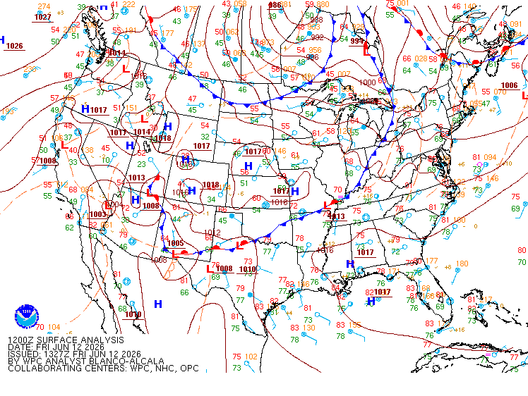
From the surface analysis above, the cold front seen from the satellite image earlier is marked in that location. Over the southeast U.S. though, we have high pressure over us keeping the region hot, humid, and dry. This changes going into next week as that ridging pattern weakens and troughing moves in, bringing with it a weak cold front that will trigger showers and thunderstorms for much of the region.
Below on the PWAT Anomaly forecast model, we can see when the cold front makes our way into the region indicated by the long line of brown next to the green on Tuesday. The front brings in slightly dry air, but it does not last for long as that moisture dominates. From this, it also tells us that it is mostly a lot more moist than normal, which can support heavy rainfall and localized areas of flash flooding.

A lot of models point to the possibility of rain starting to impact the southeast U.S. Monday, starring in the western part of the region and progressing. This will continue to be monitored to find out exactly when rain will impact the region.
3-DAY TRAVEL FORECAST
AIRPORTS
KIAH/KHOU (Houston) – No weather-related delays are anticipated on Saturday. Today there is a slight chance of showers, but nothing significant enough to expect delays to any flights. On Sunday, there is a greater chance of showers and thunderstorms, thunderstorm chances increasing after 1pm and overnight, so delays due to lightning are possible.
KSHV (Shreveport) – No weather-related delays are anticipated on Saturday. Today and Sunday there are chances of showers and thunderstorms after 1pm, so delays due to lightning are possible in the afternoon. Sunday has the greatest potential of thunderstorms. Delays can be anticipated in the afternoon through the night.
KBTR (Baton Rouge) – No weather-related delays expected today or tomorrow. Patchy fog is possible early tomorrow morning, but it is not expected to impact aviation. With a higher chance of showers and thunderstorms, Sunday could see delays due to lightning in the afternoon and overnight.
KJAN (Jackson) – No weather-related delays expected today or tomorrow. Sunday afternoon and night could see delays due to lightning as there are chances of showers and thunderstorms.
KMSY (New Orleans) – Possible delays due to lightning each day with showers and thunderstorms in the afternoon. Today the greatest chance is between 2pm and 5pm. Sunday could see delays overnight into Monday.
KMOB (Mobile) – No weather-related delays expected Saturday and Sunday. Today there is a slight chance of showers and thunderstorms after 1pm, so delays due to lightning are possible this afternoon. Delays are not expected tonight.
KATL (Atlanta) – No weather-related delays expected today. A slight chance of showers and thunderstorms could bring lightning delays Saturday evening and overnight. Greatest chance for delays is Sunday afternoon through the night as the precipitation potential is high.
KTLH (Tallahassee) – Possible delays due to lightning each day and night with showers and thunderstorms in the afternoon/overnight. Today has a slight chance, chances increasing Saturday and Sunday.
KBHM (Birmingham) – Possible delays due to lightning each day and night with showers and thunderstorms in the afternoon/overnight. Today has the lowest chance mainly after 4pm into the late evening. Chances increase Saturday and even more Sunday afternoon and overnight.
HIGHWAYS
I-10 – Showers start to pop up around 2pm today along the coast of Alabama and Louisiana near I-10 and will continue to develop into the late evening. Afternoon pop-up showers each day, but most of I-10 will remain clear for the next days.
I-20 – I-20 will stay mostly clear of showers today, but around 6pm showers and a chance of thunderstorms will start to form near I-20 in Alabama, Mississippi, and northeastern Louisiana. Same pattern for tomorrow, Sunday sees greatest chance for rain along I-20 in the afternoon and overnight. If driving at night, make sure to be cautious of this.
I-49 – Afternoon showers and thunderstorms are possible each day, today will see showers starting to fire up around 4pm and continue into the evening. Same trend for Saturday and Sunday, seeing more rain starting in the morning into the rest of the day.
I-55 – Afternoon showers and thunderstorms are possible each day, heavier showers and storms in northern Mississippi each day. Saturday has a line of thunderstorms passing through northern Mississippi in the afternoon, so be cautious of that! More rain Sunday overnight as well.
I-59 – Will stay mostly clear of showers today, but around 6pm showers and a chance of thunderstorms will start to form and progress into the late evening and night. Tomorrow afternoon, northern Alabama will see more rain along I-59. Chances of rain increase Sunday even overnight, so be cautious if driving at night.
I-65 – Afternoon showers and thunderstorms are possible each day in the afternoon, showers get more moderate in central/northern Alabama. If heading north out of Alabama into Tennessee, be cautious tomorrow night as there is a line of showers and thunderstorms that can possibly impact I-65 up in the Alabama/Tennessee border.
I-75 – Afternoon showers and thunderstorms are possible each day in the afternoon, today will not see as much. Tomorrow, expect a lot more showers and thunderstorms, starting around 2pm and continuing until around 2am for central/southern Georgia. Sunday will see afternoon showers.
CITY FORECASTS
Houston, TX
Today/Tonight – A 20% chance of showers for today, nothing too significant. Mostly sunny skies with a high of 92, heat index values are high, slightly above 100 so make sure to take care of yourself! Tonight the low will be around 77, winds from the south with partly cloudy skies.
Tomorrow – No chance of rain tomorrow and mostly sunny skies. It will be pretty hot with a high near 92 and heat index values above 100. Dewpoints will be in the low to mid 70s, so it will be humid. Wind gusts could reach 20 mph. The low will fall in the upper 70s, so not a lot of room for relief.
Sunday – Sunday has a 60% chance of showers and thunderstorms, thunderstorm chances increasing as the day progresses. The high will fall in the low 90s and winds increase to 5-10 mph in the afternoon. Rain and thunderstorms will continue overnight and the low will fall in the upper 70s.
Shreveport, LA
Today/Tonight – Today’s high is 94 and there is a 20% chance of showers and thunderstorms in the afternoon. The heat index is slightly higher than 100 today, so stay hydrated! Tonight there is no chance of rain, low falling to 76.
Tomorrow – It will be hot! The high falls near 95 and it will be sunny, so take care of yourself if you will be outside! Winds will be from the southeast around 5-10 mph. The low will fall near 78, so not much relief.
Sunday – There are showers and thunderstorms possible in the afternoon, chance of precipitation at 60%. The high will fall in the lower 90s and winds will be from the southwest at 5-10 mph. The low will drop a little more, falling to the low 70s! Rain and thunderstorms will continue overnight.
Baton Rouge, LA
Today/Tonight – No chance of rain today, mostly sunny skies and a high of 94. Tonight will have mostly clear skies, the low falling to 76 and light winds.
Saturday – Around 7am patchy fog is possible, but after that it will be a sunny and hot day with a high near 94. The low will fall to 76, winds from the southwest around 5-10 mph. No chance of rain.
Sunday – Sunday will possibly see showers and thunderstorms, 30% chance of precipitation in the afternoon. The high will be in the mid 90s and low will fall in the mid 70s. Chance of showers and thunderstorms continues overnight into Monday.
Jackson, MS
Today/Tonight – The National Weather Service put Jackson under a heat advisory for today and tonight, the high is 94 with mostly sunny skies. The heat index is 101. Tonight, the low will be around 77 with calm winds and partly cloudy skies.
Tomorrow – Still under the heat advisory, the high will be near 95 and the heat index can reach as high as 105. It will be sunny. The low will fall around 77, winds from the southwest around 5 mph.
Sunday – A 50% chance of showers and thunderstorms for Sunday afternoon. The high will fall in the low 90s, winds from the west at 5-10 mph. Showers and thunderstorms will continue Sunday night, rainfall amounts as much as a half inch possible.
New Orleans, LA
Today/Tonight – Today has a 30% chance of showers and thunderstorms between 2pm and 5pm. The high will be around 90 with southeast winds around 5-10 mph. There is a slight chance for showers tonight before 7pm and a low around 77.
Tomorrow – There is a slight chance of showers and thunderstorms tomorrow afternoon. The high will be around 92 and the low will be around 78. Chance of precipitation is 20%.
Sunday – Sunday has a slight chance of showers and thunderstorms in the afternoon, chance of precipitation is 20%. Chances continue overnight into Monday. The high will fall in the low 90s and the low in the upper 70s.
Mobile, AL
Today/Tonight – There is a 20% chance of showers and thunderstorms this afternoon. Other than that, skies are mostly sunny and the high is 92. Tonight’s low will fall around 75, winds from the southwest around 5-10 mph.
Tomorrow – No chance of rain tomorrow, mostly sunny skies and a high near 93. The low will fall around 76, winds from the southwest around 5-10 mph. It will be hot so make sure to take care of yourself and maybe go swimming!
Sunday – Sunday will be hot, high falling in the mid 90s and sunny skies. Sunday night will see a good chance of showers and thunderstorms going into Monday. The low will fall in the mid 70s, winds from the southwest at 5-10 mph.
Atlanta, GA
Today/Tonight – Today will be mostly sunny with a high near 93. The low will fall to 75, no chance of rain today or tonight. Winds are from the west around 5 mph.
Tomorrow – Slight chance of showers and thunderstorms in the evening and overnight. Other than that, mostly sunny skies and a high of 92, low of 74. Winds are northwest/west around 5mph.
Sunday – Sunday has a 70% chance of showers and thunderstorms mainly in the afternoon and overnight. The high will be near 90 and low in the low 70s. Wind gusts could reach 20 mph.
Tallahassee, FL
Today/Tonight – A slight chance of showers and thunderstorms this afternoon at 10%. It will be mostly sunny and hot today, a high of 96. Tonight also has a slight chance of showers and thunderstorms, low around 77. Winds from the southwest around 5-10 mph.
Tomorrow – A 40% chance of showers and thunderstorms Saturday afternoon. Before that though, it will be hot with mostly sunny skies and a high near 97. The low will fall around 77 and chance for rain continues into the late evening.
Sunday – Sunday has a 50% chance of showers and thunderstorms in the afternoon. Before that, mostly sunny skies and a high in the mid 90s. Chance of rain continue in the late evening, and the low will fall in the upper 70s. Winds are from the west around 5-10 mph.
Birmingham, AL
Today/Tonight – A slight chance of rain this afternoon at 20%. The high will fall near 93 and the low around 74. Chance of showers and thunderstorms continues tonight. Winds are from the west around 5 mph.
Tomorrow – Tomorrow has a 40% chance of showers and thunderstorms in the afternoon. Before that, mostly sunny skies and the high will reach near 93. Tomorrow night, chance of rain continues and the low falls to 74. Winds are calm from the west.
Sunday – Showers and thunderstorms are likely Sunday afternoon. The chance of precipitation is 60%. The high will be in the low 90s and the low will fall in the low 70s. Chance of showers and thunderstorms continues overnight. Winds are calm.


