While heat is the main story this weekend, with a heat advisory in effect for Tallahassee and heat indices above 100 across the region, tomorrow is the beginning of a long stretch of wet weather. Pack an umbrella if traveling and keep phone alerts on, as the risk of flash flooding begins tomorrow and continues through the week.
A surface low and cold front are currently just north of the Gulf states. A trough in the jet stream will gently push the system southward.
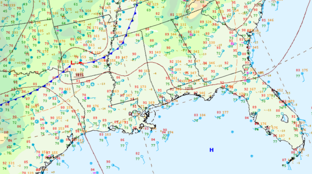
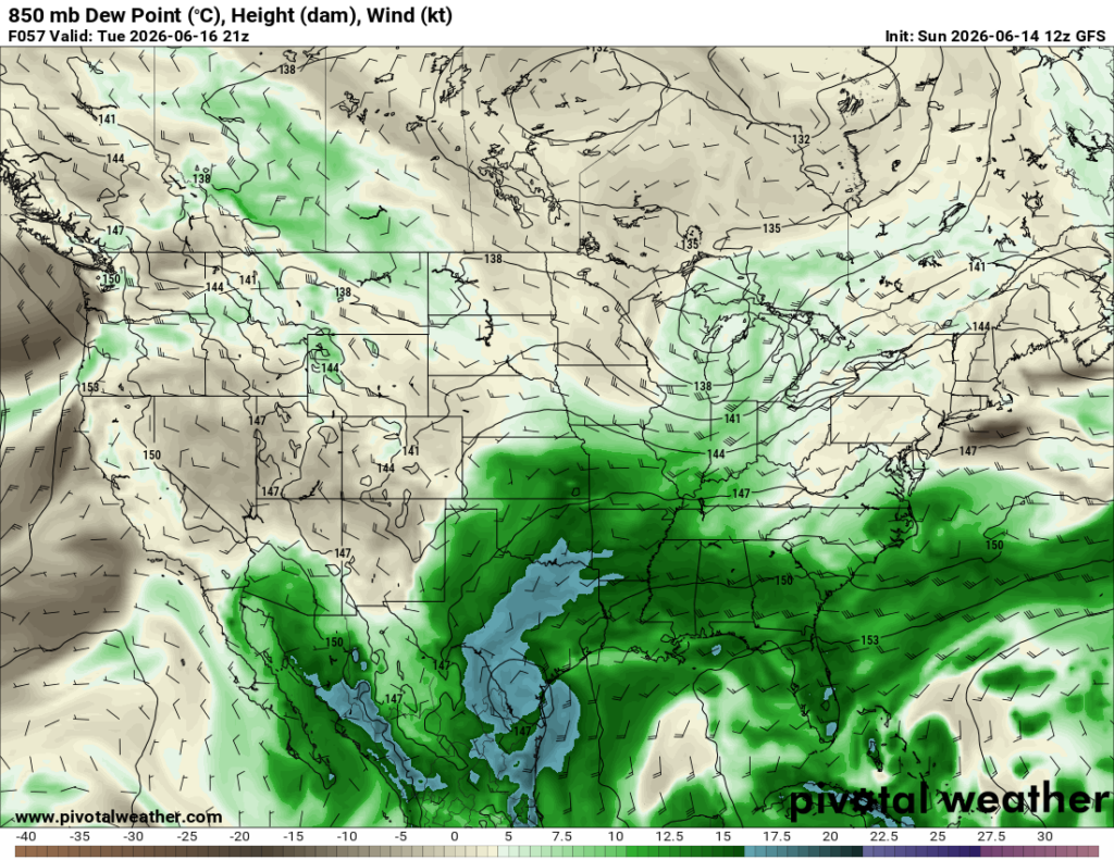
Once the front gets here, it’s going to hang around for a while as a stationary boundary. Down at 850 mb, we’ll have a persistent southwesterly flow off the Gulf, pulling in a ton of available moisture.
When you combine a stalled front with a surge of tropical moisture, that’s a notorious setup for some pretty impressive rainfall totals. On top of that, another plume of deep moisture is expected to move into the region later this week. That could bring localized flash flooding along with river flooding.
We’re expecting scattered showers and thunderstorms capable of dumping a lot of rain in a short amount of time, with some storms potentially training over the same locations for several hours.
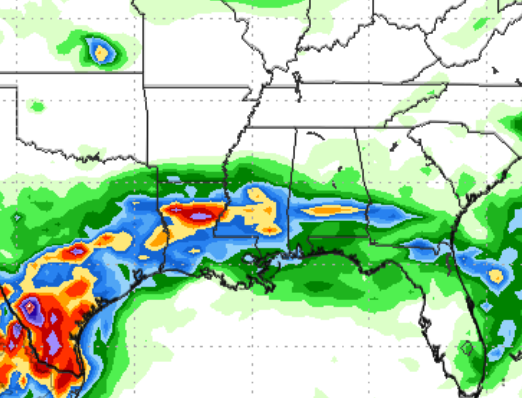
The GFS and Euro are both keying in on the heaviest rainfall across northern Louisiana and central Mississippi, while rainfall totals drop off pretty quickly as you get closer to the Gulf Coast, as shown below.

Main threats this week will be flooding and damaging winds. The flash flooding threat will be more localized and mainly in areas that see repeated rounds of storms.
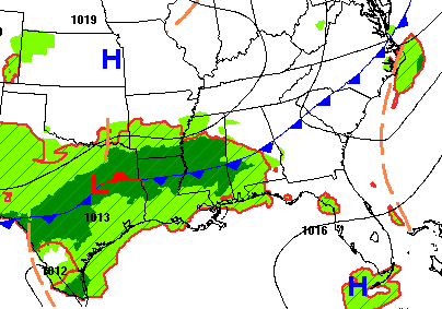
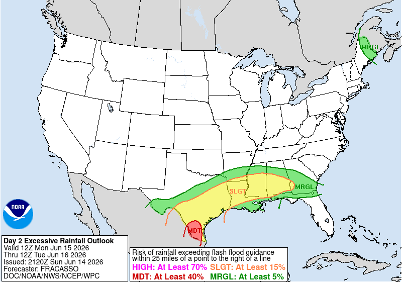
There is a Slight Risk (Level 2/4) for excessive rainfall Monday through Wednesday across parts of the southern Gulf states, meaning an isolated risk of significant flash flooding along with minor river flooding.
3-DAY TRAVEL FORECAST
AIRPORTS
KIAH / KHOU (Houston) – Flood Watch in effect through Tuesday. Showers and thunderstorms possible each day, with minor roadway flooding in spots that see repeated rain. Intermittent flight delays are also possible due to lightning.
KSHV (Shreveport) – Showers and thunderstorms possible each day, with minor roadway flooding in spots that see repeated rain. Intermittent flight delays are also possible due to lightning.
KBTR (Baton Rouge) – Chance of showers and thunderstorms each day. Watch for minor roadway flooding, especially in areas that see repeated rain. Intermittent flight delays are also possible due to lightning.
KMSY (New Orleans) – Chance of showers and thunderstorms each day, with the highest coverage expected Tuesday and a lower-end chance Monday. Intermittent flight delays are also possible due to lightning.
KJAN (Jackson) – Chance of showers and thunderstorms each day. Watch roadways for minor flooding, especially in areas that see repeated rain. Intermittent weather delays possible for some flights due to lightning.
KMOB (Mobile) – Chance of showers and thunderstorms each day. Watch roadways for minor flooding, especially in areas that see repeated rain. Intermittent weather delays possible for some flights due to lightning.
KBMH (Birmingham) – Patchy fog possible Tuesday morning. Chance of showers and thunderstorms each day, with the highest coverage expected Tuesday. Watch for minor roadway flooding, especially in areas that see repeated rain. Intermittent flight delays are also possible due to lightning.
KTLH (Tallahassee) – Monday features scattered storms, mainly between 2–5 PM, with intermittent weather delays possible due to lightning. Tuesday brings showers and thunderstorms developing in the afternoon, with lightning delays possible and watch for roadways for ponding.
KATL (Atlanta) – Low-end chance of scattered storms Monday evening. Tuesday brings a higher chance of showers and thunderstorms, with intermittent flight delays possible due to lightning.
HIGHWAYS
I-10
Monday morning could see scattered storms across western Louisiana, with evening storms developing across the southern Gulf states and the Florida Panhandle. Tuesday brings ongoing showers along the I-10 corridor, with pockets of heavy rainfall possible, watch roadways for minor flooding. Isolated heavier showers could lead to brief flash flooding.
I-20
Tonight, through Monday morning, heavy rainfall is expected along I-20 across northern Louisiana, central Mississippi, and Alabama. Tuesday morning, heavy rainfall is possible around Shreveport and Jackson, with scattered storms producing heavy downpours at times. Training storms may lead to minor roadway flooding, keep weather alerts on for flash flood warnings.
I-49
Rainfall, showers, and thunderstorms are expected over the next three days, with training storms capable of producing high rainfall rates and localized flooding. Rain totals will gradually decrease as you head south toward the coast. Watch roadways for flooding, especially near Shreveport. Turn around, don’t drown!
I-55 & I-59
Showers and thunderstorms in central Mississippi, with the highest rainfall rates near Jackson. Rain totals decrease as you head south toward the coast. Watch roadways for flooding, turn around, don’t drown.
I-65
Monday afternoon and evening, scattered showers and thunderstorms are expected south of Montgomery. Tuesday brings higher storm coverage with heavy downpours that could reduce visibility. Watch roadways for flooding.
I-75
Monday evening, strong showers and thunderstorms are possible across southern Georgia and northern Florida. Tuesday brings widespread showers with brief downpours that could reduce visibility. Watch roadways for minor flooding.
CITY FORECASTS
Houston, TX
Tonight – Scattered storms continue. Mostly cloudy, low around 79. South wind around 5 mph.
Monday – Showers and thunderstorms throughout the day. High around 86, southwest wind around 5 mph. Watch for ponding on roadways.
Tuesday – More showers and storms expected. High around 83, southerly wind around 5 mph. Minor roadway flooding possible.
Shreveport, LA
Tonight– Scattered storms will diminish overnight. Low around 73. North wind around 5 mph.
Monday – Showers and thunderstorms return in the morning and continue through the day. High near 82, calm northeasterly wind.
Tuesday – Isolated to scattered showers and storms possible. Mostly cloudy, high near 86, southerly wind around 5 mph. Watch roadways for minor flooding.
Baton Rouge, LA
Tonight– Scattered showers and thunderstorms. Mostly cloudy, low around 78, calm southwest wind.
Monday – Showers and thunderstorms likely through the day, with activity tapering to a low-end chance after 7 PM and overnight. High near 88, southwest wind around 5 mph.
Tuesday – Showers and possibly a thunderstorm, with some storms capable of heavy rainfall. High near 81. Watch for minor roadway flooding.
New Orleans, LA
Tonight– Mostly cloudy, low around 80. Can’t completely rule out a scattered storm.
Monday – Showers and thunderstorms, mainly after 11 a.m. Otherwise partly sunny with a high near 91, west wind around 10 mph.
Tuesday – Showers and possibly a thunderstorm, with some storms capable of heavy rainfall. High near 84. Watch for minor roadway flooding, southwest wind around 10 mph.
Jackson, MS
Tonight– Showers and possibly a thunderstorm. Low around 73. Calm northwest wind.
Monday – Showers and thunderstorms, with most coverage after 5 PM. High near 81. Calm wind becoming west-southwest around 5 mph in the morning.
Tuesday – Showers and possibly a thunderstorm, with some storms capable of heavy rainfall. High near 82. Watch for minor roadway flooding.
Birmingham, AL
Tonight– Partly cloudy, low around 70. Can’t completely rule out a scattered storm.
Monday – Slight chance of showers after 1 PM. Otherwise mostly cloudy with a high near 81.
Tuesday – Patchy fog before 7 AM. Showers and possibly a thunderstorm, with a high near 81. Calm wind becoming southwest around 5 mph in the afternoon. Some storms could produce heavy rainfall, watch for minor roadway flooding.
Mobile, AL
Tonight– Partly cloudy, low around 80. Can’t completely rule out a scattered storm.
Monday – Showers and thunderstorms, mainly after 7 a.m. High near 88, west wind 5 to 10 mph.
Tuesday – Showers and possibly a thunderstorm, with some storms capable of heavy rainfall. High near 83, southwest wind 5 to 10 mph. Watch for minor roadway flooding.
Tallahassee, FL
Tonight– Partly cloudy, with a low around 73. West southwest wind around 5 mph.
Monday – Scattered storms, mainly between 2pm and 5pm. Mostly sunny, with a high near 91. Summer like heat, experienced temperatures as high as 102. West wind 5 to 10 mph.
Tuesday – Showers and thunderstorms likely, mainly after 2pm. Partly sunny, with a high near 86. West southwest wind 5 to 10 mph. Watch roadways for minor flooding
Atlanta, GA
Tonight– A chance of showers and thunderstorms, mainly before midnight. Mostly cloudy, with a low around 71. West wind 5 to 10 mph, with gusts as high as 15 mph.
Monday – Mostly sunny with a high near 83, with a low-end chance of scattered evening storms. Northwest wind around 10 mph, gusts up to 15 mph.
Tuesday – Showers and thunderstorms likely. Mostly cloudy, with a high near 81. West wind around 5 mph.


