Potential Tropical Cyclone #1 brings in loads of rainfall for the Central Gulf. Double-digit rainfall over the week is expected in some areas, with active flood and flash flood warnings across the region.
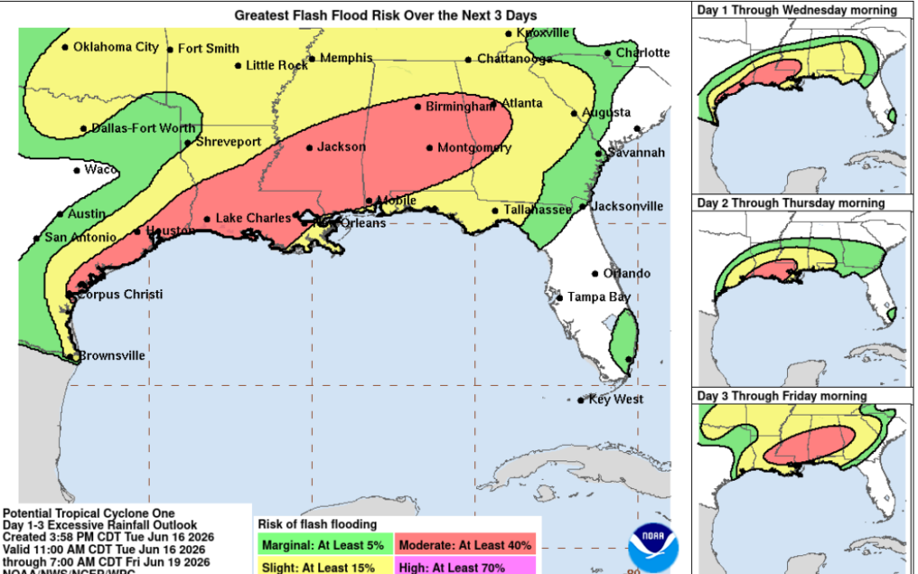
The above graphic is why this storm needs to be taken seriously. Even though it isn’t named and isn’t even a tropical storm, severe flash flooding has already occurred in Shreveport along other areas in the region. The rainfall associated with this storm is dangerous and if you are anywhere in green, yellow, and especially red, make sure you and your family are prepared.
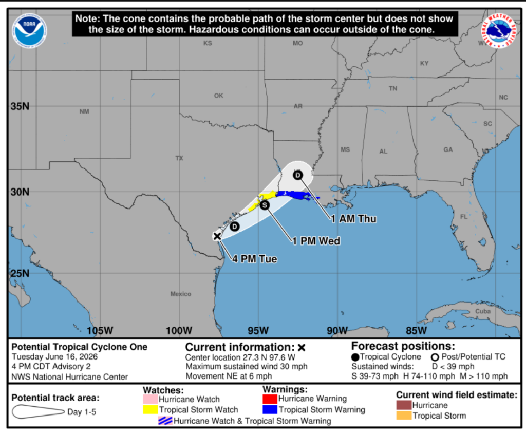
Now, the reason for all this mess would be Potential Tropical Cyclone #1 for our Atlantic season. This storm, despite the odds, looks to be pushing inland at right about the 24 hr mark around the Galveston area, where it will continue trekking NE into Louisiana territory. This storm will bring heavy rainfall to our entire Central Gulf region along with the isolated risk for tornadoes since the atmosphere is already primed by this system.
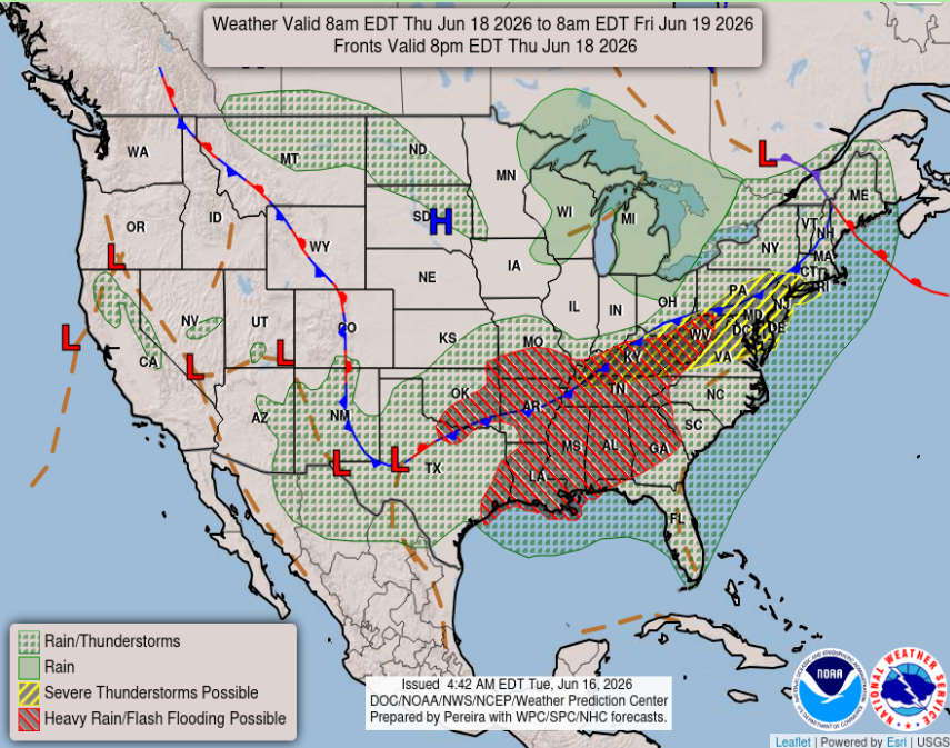
Here’s what were looking at on Thursday the 18th. Much of our coverage area is under a heavy rain and flash flood watch as this tropical mess moves inland and East. Much of the region has already received bucketloads of rain, so this already saturated soil + potential heavy rain puts our area at a high risk for flooding.
The primary concerns across the South will be heavy rainfall, flooding, gusty winds, and isolated severe weather embedded in the outer rainbands. While this system is not expected to be a major wind event, gusts of 30-45 mph will be prevalent in the stronger outer bands impacting the coast. This will be a major rainfall event with rotation and instability that can potentially form tornadoes. Again, ensure you and your loved ones are prepared for this storm as impacts will continue through the rest of the week.
3-Day Travel Forecast
AIRPORTS
KIAH / KHOU (Houston) – Delays are possible due to thunderstorms and water accumulation on runways.
KSHV (Shreveport) – Mild delay risk due to heavy rainfall from Yesterday/Monday and the inland-moving tropical system.
KBTR (Baton Rouge) – Expect delays from heavy rainfall and incoming tropical system.
KMSY (New Orleans) – Delays expected from past rainfall and incoming tropical system.
KJAN (Jackson) – Delays expected from tropical system and flooding.
KMOB (Mobile) – High risk of delays from tropical system impacting flight operations.
KBMH (Birmingham) – Risk of delays from the incoming tropical system.
KTLH (Tallahassee) – Expect delays from heavy rainfall associated with thunderstorms.
KATL (Atlanta) – Risk increases day by day as the tropical system moves inland.
Highways
*IF YOU ENCOUNTER A FLOODED ROADWAY: TURN AROUND, DON’T DROWN*
I-10: Expect heavy rain and flooding on roadways across most of the corridor, take extra precaution from Tallahassee to Houston.
I-20: Expect flooded roadways in the Shreveport area today, flooding is expected across the region.
I-49: Travelers will encounter heavy rain and potential roadway flooding, use extreme caution.
I-55 & I-59: Expect flooding in low-lying areas, flooding chances decrease as you travel North.
I-65: Flooding can be expected on the southern portion on I-65, use caution
I-75: Storms are possible across the area, take caution when traveling North as the tropical system moves east.
3-Day City Forecast
Houston, TX: Tuesday (16th): Thunderstorms throughout the day. High 81°F, low 76°F.
Wednesday (17th): Wind and heavy rain across the area. High 87°F, low 79°F.
Thursday (18th): Partly cloudy with a chance of thunderstorms. High 93°F, low 81°F. *FLOOD WATCH UNTIL 7AM THURSDAY*
Shreveport, LA: Tuesday (16th): Mostly cloudy with thunderstorms. High 87°F, low 73°F.
Wednesday (17th): Mostly sunny with isolated afternoon thunderstorms possible. High 91°F, low 76°F.
Thursday (18th): Showers and storms throughout the day. High 93°F, low 77°F.
Baton Rouge, LA: Tuesday (16th): Foggy with thunderstorms. High 79°F, low 75°F.
Wednesday (17th): Foggy with showers leading into thunderstorms. High 86°F, low 76°F.
Thursday (18th): Showers with the occasional thunderstorm. High 87°F, low 78°F. *FLOOD WATCH UNTIL 7AM THURSDAY*
New Orleans, LA: Tuesday (16th): Thunderstorms and showers. High 83°F, low 77°F.
Wednesday (17th): Thunderstorms dissipating into showers. High 87°F, low 78°F.
Thursday (18th): Thunderstorms and showers throughout the day. High 88°F, low 80°F. *FLASH FLOOD WARNING UNTIL 8PM TUESDAY II FLOODWATCH UNTIL 7AM FRIDAY*
Jackson, MS: Tuesday (16th): Mostly cloudy with thunderstorms. High 81°F, low 71°F.
Wednesday (17th): Showers with thunderstorms possible. High 89°F, low 74°F.
Thursday (18th): Alternating showers and thunderstorms. High 86°F, low 74°F. *FLOOD WATCH UNTIL 7AM THURSDAY*
Birmingham, AL: Tuesday (16th): Mostly cloudy with occasional showers. High 77°F, low 68°F.
Wednesday (17th): Partly sunny with some thunderstorms in the afternoon. High 87°F, low 73°F.
Thursday (18th): Alternating showers and thunderstorms. High 82°F, low 71°F. *FLOOD WATCH 12AM THURSDAY- 7AM FRIDAY *
Mobile, AL: Tuesday (16th): Thunderstorms. High 82°F, low 75°F.
Wednesday (17th): Alternating showers and thunderstorms. High 87°F, low 80°F.
Thursday (18th): Showers and thunderstorms. High 86°F, low 79°F. *FLOOD WATCH UNTIL 7PM FRIDAY*
Atlanta, GA: Tuesday (16th): Showers with a chance of thunderstorms. High 82°F, low 67°F.
Wednesday (17th): Showers and thunderstorms. High 85°F, low 72°F.
Thursday (18th): Alternating showers and thunderstorms. High 84°F, low 70°F. *FLOOD WATCH 8AM THURSDAY- 2AM SATURDAY*
Tallahassee, FL: Tuesday (16th): Heavy rain with showers into the night. High 85°F, low 73°F.
Wednesday (17th): Mostly cloudy with showers. High 86°F, low 77°F.
Thursday (18th): Alternating showers and thunderstorms. High 89°F, low 76°F.


