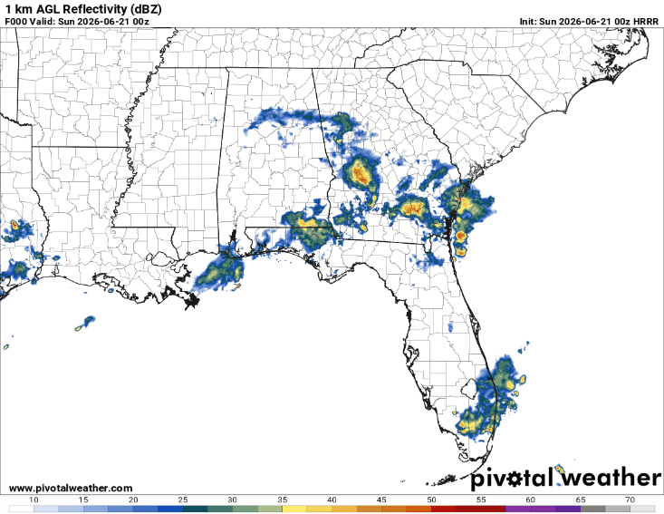
Pack an umbrella for any Father’s Day outdoor plans! Numerous scattered showers and thunderstorms are expected tomorrow. It won’t be a complete washout, but the weather could still disrupt outdoor activities at times, with the highest rainfall totals expected north of the I-20 corridor.
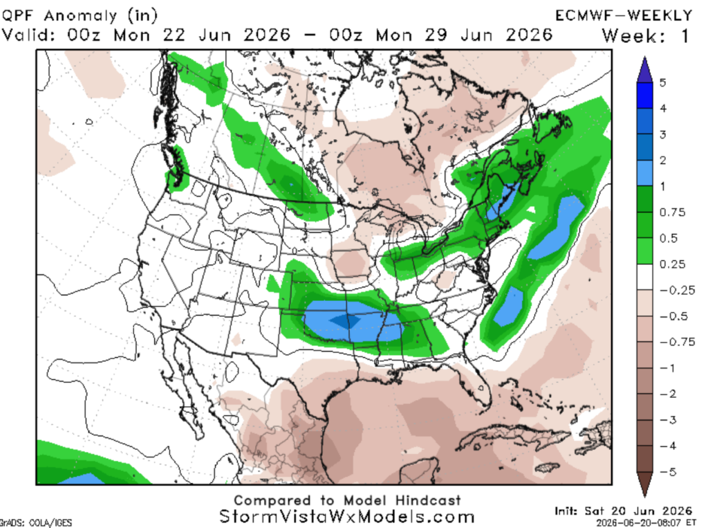
Fortunately, ridging expands northward across the region and builds in by Sunday for the southernmost parts of the Gulf states, remaining in place through next week. This means a return of more normal rain chances and heat.
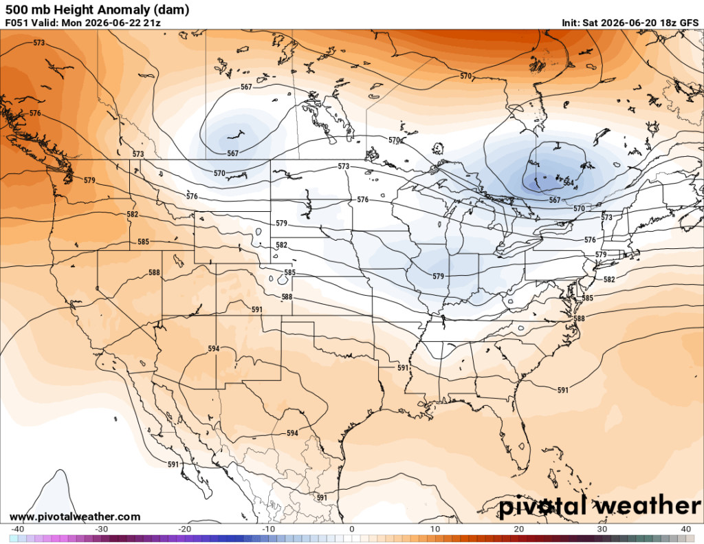
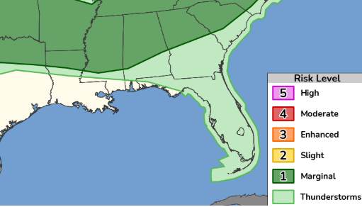
For those in the northernmost parts of the Gulf states, higher than normal rain chances will persist next week as a front approaches the area. With this, severe weather makes a return.
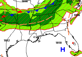
On Monday, a Marginal Risk (Level 1 of 5) for severe storms is forecasted across northern Louisiana, Mississippi, and Alabama during the afternoon and evening hours. A strong line of storms is expected to move in from the northwest bringing damaging winds up to 60 mph and heavy downpours.
Model guidance looking out into next week agrees and points to below-normal to normal conditions across the southern Gulf states, with soggy conditions for those in northern Mississippi and Alabama.
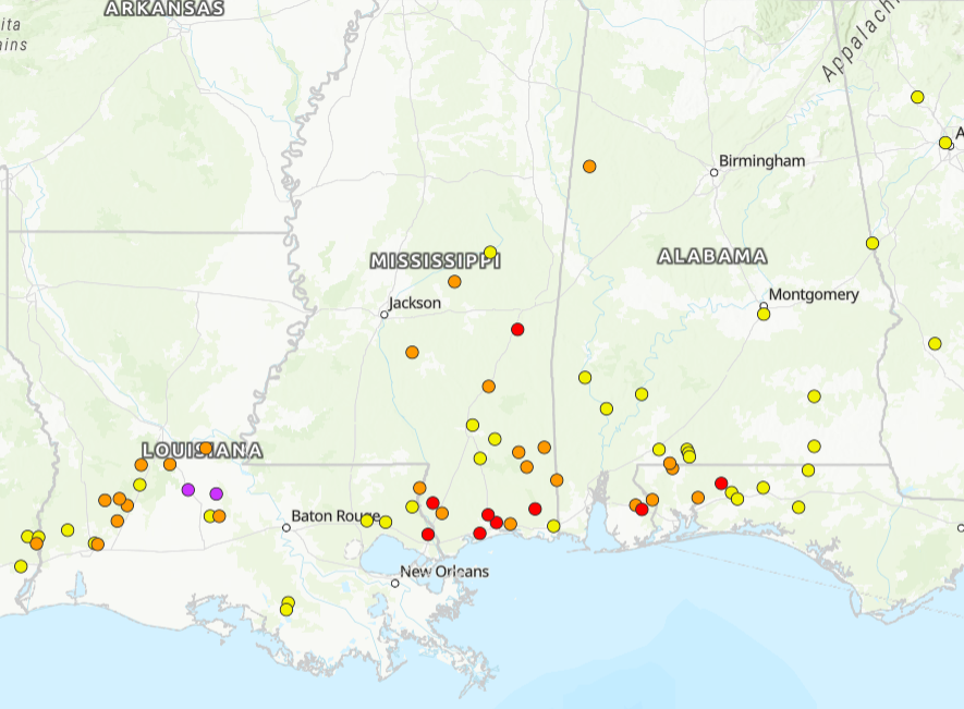
River levels have improved, however, a good number are still within minor (orange dots) to moderate (red dots) flood stage. Most rivers are forecasted to recede back to normal by Wednesday, with the exception of the Pearl River, which may remain elevated until June 30th.
It’s important to note where these flooded rivers are if you are driving and watch for water on the roads!
3-DAY TRAVEL FORECAST
AIRPORTS
KIAH / KHOU (Houston) – Scattered showers and thunderstorms tonight, lingering into tomorrow morning before drying out by 2 PM. Some intermittent flight delays are possible due to lightning. Most flights Sunday afternoon and evening should not be impacted by weather.
KSHV (Shreveport) – Scattered storms Sunday afternoon and evening; flash flooding may be possible. Some intermittent flight delays are possible for lightning. Monday night brings a low-end chance of thunderstorms.
KBTR (Baton Rouge) – Minor flooding ongoing today near the Pascagoula River at Graham Ferry. Lingering showers tonight; watch for minor flooding. Isolated storms tomorrow, mainly before 4 PM. Heavy rainfall may reduce visibility, and intermittent flight delays possible due to lightning.
KMSY (New Orleans) – Isolated storms tomorrow, mainly before 2 PM. Heavy rainfall may reduce visibility, and intermittent flight delays possible due to lightning.
KJAN (Jackson) – High chance of showers and thunderstorms both Sunday and Monday, mainly in the afternoon and evening hours. Monday night, some storms could be severe with damaging wind gusts and heavy downpours. Some intermittent flight delays are possible for lightning.
KMOB (Mobile) – Chance of scattered storms in the morning and afternoon on Sunday. Intermittent flight delays possible due to lightning, mainly before 4 PM
KBMH (Birmingham) – Flood Warning in effect tonight. Be cautious at night and watch for flooded roadways. Showers and thunderstorms likely Sunday afternoon and evening. A greater threat for severe storms arrives Monday afternoon and evening. The primary threat is damaging wind gusts up to 60 mph. Some intermittent flight delays are possible for lightning.
KTLH (Tallahassee) – Low-end chance for afternoon showers and storms possible each day. Some intermittent flight delays are possible for lightning. But most flights between 10a and 4p should be not be impacted by weather.
KATL (Atlanta) – Low-end chance for afternoon showers and storms Sunday. A greater threat for severe storms arrives Monday afternoon and evening. The primary threat is damaging wind gusts up to 60 mph. Some intermittent flight delays are possible for lightning.
HIGHWAYS
I-10
Be cautious driving through southern Mississippi as rivers remain in flood stage. Watch for flooded roadways through Tuesday. Sunday there is a chance of scattered showers near Mobile and Hattiesburg, mainly in the afternoon and evening.
I-20
Be cautious driving through Jackson as rivers remain in flood stage. Watch for flooded roadways through Tuesday.
Sunday afternoon, numerous showers and thunderstorms are expected near Shreveport and Jackson, moving east toward Birmingham by the evening, with minor ponding possible on roadways.
On Monday, severe weather is possible near Birmingham with damaging wind gusts, line of storms will move south into Jackson and Shreveport during the evening.
I-49
Be cautious driving through Whiteville as rivers remain in major flood stage. Watch for flooded roadways through Tuesday.
Sunday, heavy rainfall near Alexandria is expected in the early afternoon, moving north with widespread showers mainly across northern Louisiana. Monday evening could see intense downpours and severe storms near Shreveport, with reduced visibility and damaging wind gusts.
I-55 & I-59
Be cautious driving through Jackson as rivers remain in flood stage. Watch for flooded roadways through Tuesday.
Sunday, numerous scattered showers and thunderstorms are expected across central Mississippi in the afternoon, moving northeast through the evening. Lookout for water on the roads and some ponding possible.
Monday, a severe line of storms moves south beginning near West Memphis in the morning and reaching Jackson by around 7 PM, with damaging wind gusts and reduced visibility.
I-65
Flood warning in effect today for Birmingham; watch for water on roads.
Sunday evening, scattered showers near Mobile in the afternoon move northeast, reaching Birmingham by around 7 PM.
Monday, a severe line of storms moves south beginning near Decatur in the afternoon and reaching Montgomery by around 7 PM, with damaging wind gusts and reduced visibility.
I-75
Lingering showers tonight near and south of Macon, expected to dissipate by midnight.
Sunday afternoon and evening, spotty storms across northern Florida and southern Georgia.
Monday, a strong line of storms is expected in Atlanta during the evening along I-75, moving south through the late evening. Damaging wind gusts and reduced visibility are possible; watch for water on roadways, especially in north Georgia.
CITY FORECASTS
Houston, TX
Tonight– Lingering scattered thunderstorms and showers overnight. Flash flooding is possible, especially in areas with saturated grounds. Low 79. Light southeasterly wind. Rain chance: 30%
Sunday – Lingering scattered thunderstorms in the morning, becoming partly sunny by 2 PM. High 91, heat indices values near 107. South wind 5 to 15 mph, with gusts as high as 20 mph.
Monday – Mostly sunny and breezy. High near 93 but may feel 10 degrees warmer. South wind around 10 mph, with gusts as high as 20 mph.
Shreveport, LA
Tonight – Staying dry tonight, mostly clear, with a low of 75. Southeast wind around 5 mph.
Sunday – Scattered storms moving from the south during the afternoon and into the evening. With rain falling on already heavily saturated soils, flash flooding will be possible. Otherwise, mostly sunny, with a high of 93. Southwesterly winds 5-15 mph. Rain chance: 30%
Monday – Partly sunny, with a high near 93, may feel 10 degrees warmer. Low-end chance of an isolated storm in the evening and overnight hours. Rain chance: 20%
Baton Rouge, LA
Tonight – Minor flooding ongoing near Pascagoula River at Graham Ferry. A few isolated thundershowers and showers may linger overnight under mostly cloudy skies. Storms could produce heavy rainfall, with rates of 2–3 inches per hour. Localized flash flooding is possible in areas that receive the strongest storms. Low around 76. Southeast wind around 5 mph. Rain chance: 40%
Sunday – A few isolated thunderstorms are possible until 4 PM, but most spots will stay dry. Otherwise, partly sunny with a high near 90. South wind 5 to 15 mph. Rain chance: 30%
Monday– Sunny, drier weather brings daytime highs back to 93 and may feel 10 degrees warmer. Southwest wind 5 to 10 mph.
New Orleans, LA
Tonight– A few isolated thundershowers and showers may linger overnight under mostly cloudy skies. Storms could produce heavy rainfall, with rates of 2–3 inches per hour. Localized flash flooding is possible in areas that receive the strongest storms. Low around 78. Southeast wind around 5 mph. Rain chance: 30%
Sunday– A few isolated thunderstorms are possible until 2 PM, but most spots will stay dry. Otherwise, partly sunny. Highs stay hovering around 90. South wind 5 to 15 mph. Rain chance: 20%
Monday– Mostly sunny, finally drier weather. Drier weather brings daytime highs back to 93 and may feel 10 degrees warmer. Southwest wind 5 to 15 mph.
Jackson, MS
Tonight – Mostly clear. Low-end chance of an isolated thunderstorm. Low around 72. Calm south wind. Rain chance: 20%.
Sunday – Showers and thunderstorms, mainly during the afternoon and evening. High near 88, but it may feel 10 degrees warmer. Rain chance: 80%. Drier conditions expected overnight.
Monday – Partly cloudy with a high near 90. Heat index values as high as 103. Southwest wind around 10 mph, with gusts up to 20 mph. Severe thunderstorms possible during the evening and overnight hours, approaching from the northeast. Damaging wind gusts and heavy downpours are possible.
Birmingham, AL
Tonight – Flooding warning in effect until 10 PM. Lingering showers and storms, diminishing after sunset and becoming mostly cloudy. Low around 71. Calm south wind.
Sunday – Showers and storms, mainly during the afternoon and evening hours. High of 87. Southwest winds 10-15mph. Rain chance: 50%
Monday – A Marginal Risk (Level 1 of 5) for severe storms is forecast during the afternoon and evening hours as a potential complex of storms moves in from the northwest. Damaging winds up to 60 mph and heavy downpours are the main threats. High near 89. Rain chance: 70%
Mobile, AL
Tonight – Scattered showers and thunderstorms lingering before becoming mostly cloudy around midnight. Low 75.
Sunday – Chance of scattered storms in the morning and afternoon. Clearing out by 4 PM. Otherwise, partly sunny with a high near 88. Light south wind. Rain chance: 50%.
Monday – Mostly sunny and warm with highs pushing the lower 90s. Overall, a fairly quiet day weather-wise with southwest winds 5-10mph.
Tallahassee, FL
Tonight – Scattered showers and thunderstorms lingering before clearing around midnight. Heavy rainfall may lead to flash flooding early tonight. Low around 72.
Sunday – Scattered showers and thunderstorms possible, mainly after 4 PM. Otherwise, mostly sunny with a high nearing 90. Rain chance: 60%
Monday – Low-end chance of thunderstorms after 2 PM. Otherwise, partly sunny with a high near 90, but it may feel closer to 103. Southwest wind 5–10 mph. Rain chance: 40%.
Atlanta, GA
Tonight – Lingering showers clear out after sunset before becoming partly cloudy. Low around 69. West wind around 5 mph.
Sunday – Mostly sunny. Temperatures and humidity will increase, with feels-like values near 100. Scattered storms possible in the evening. Rain chance: 30%.
Monday – A Marginal Risk (Level 1 of 5) for severe storms is forecast during the afternoon and evening hours as a potential complex of storms moves in from the northwest. Damaging winds up to 60 mph and heavy downpours are the main threats. High near 89. Rain chance: 60%.


