When it’s August, you get afternoon pulse storms. Or something like that.
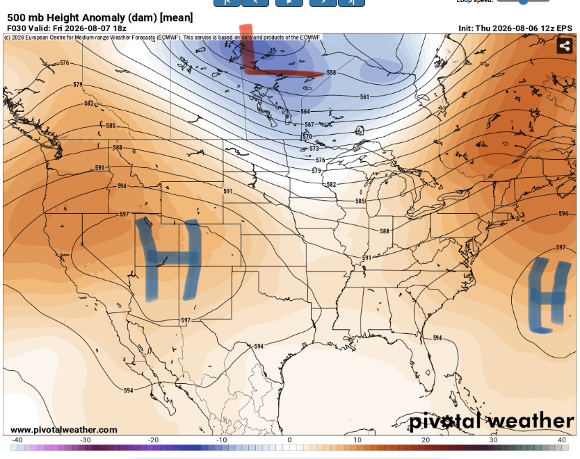
Our area is stuck in a void of weather systems between the subtropical highs to the east and west and the main trough and jet stream to the north. This will lead to a seasonably warm and thick atmosphere. Temperatures will peak in the mid 90s to the west and a bit cooler to the east due to convection.
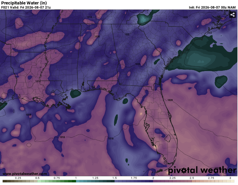
Precipitable water values will be fairly high (around two inches) allowing for a distinct humid feel along with plenty of moisture for convection. Any storms that do occur will be capable of very heavy and frequent lightning along with maybe some gusty winds as they collapse.
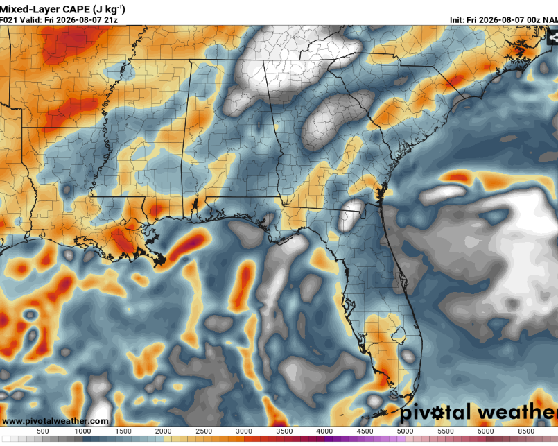
CAPE values won’t be super high but they’ll be enough to allow for intense updrafts. The main limiting factor for thunderstorm initiation and maintenance will be the lack of a short wave and significant shear. This will keep storms firmly in the pulse category. Storms will be possible area wide with the highest coverage likely located near outflow boundaries and localized convergence zones.
Fog may also be a concern in the mornings, Particularly in areas that recently received rainfall.
All in all, a typical stagnent summer pattern.
Airport Forecasts
Houston (KIAH/KHOU)- Thunderstorms possible this evening and tomorrow afternoon. These will be capable of lightning and maybe some micro bursts so a few delays are possible.
Shreveport (KSHV)- Once any storms die off this evening no further issues are expected.
Baton Rouge (KBTR)- Any storms from today die off around sunset. There is a low chance of storms tomorrow after that may cause a quick delay or two for lightning or downbursts.
New Orleans (KMSY)- Storms die off at sunset. There is a low end risk for storms tomorrow afternoon with a chance of lightning and downbursts. A delay or two is possible.
Jackson (KJAN)- Low chances of storms each of the next couple afternoons posing a risk for lightning delays. The bigger threat will be fog each of the next couple mornings which may delay flights due to low visibility.
Mobile (KMOB)- Low end chance of afternoon thunderstorms each of the next few days. These may cause a couple delays for lightning or downdrafts but it shouldn’t be anything crazy.
Birmingham (KBMH)- Afternoon thunderstorms are possible each of the next few days. This could lead to some delays for lightning or microbursts.
Tallahassee (KTLH)- Afternoon and evening thunderstorms possible each of the next couple days. There will be a chance for some lightning or downburst related delays.
Atlanta (KATL)- Storms will be in the area for the next hour or two. Storms will also be possible each of the next few afternoons as well posing a risk for some downdraft or lightning delays.
Highways
I-10 – Scattered afternoon thunderstorms possible from Houston through Florida each of the next two afternoons. It won’t be a washout but where it rains it could be very heavy.
I-20 – A few thunderstorms likely across the Southeast from Atlanta to Shreveport. Many locations will be dry but be mindful of water on pavement.
I-49 – On and off thunderstorms across western Louisiana. Most places and times will be dry but there will definitely be some thunderstorms.
I-55 and I-59 – Isolated thunderstorms possible during the next two afternoons across Mississippi. Most locations will be unaffected but those that get rain will get pounded.
I-65 – Isolated afternoon thunderstorms possible across Alabama each of the next two days. The vast majority of locations will remain dry however.
I-75 – Widely scattered storms possible across Georgia each of the next two afternoons. They won’t be anything crazy but it’ll be enough to cause ponding on the roadways.
City Forecasts
Houston, TX
Tonight- Thunderstorms die off early. Partly cloudy with a low in the upper 70s.
Tomorrow- Scattered afternoon thunderstorms possible. Increasing clouds with a high in the low 90s.
Saturday- Isolated afternoon thunderstorms possible. Mostly sunny with a high in the low 90s.
Shreveport, LA
Tonight- Any storms die off early. Decreasing clouds with a low in the mid 70s.
Tomorrow- Sunny with a high in the mid 90s. Dry.
Saturday- Sunny with a high in the mid 90s. No rain.
Baton Rouge, LA
Tonight- Any storms die off early. Partly cloudy with a low in the mid 70s.
Tomorrow- Isolated afternoon thunderstorms possible. Mostly sunny with a high in the mid 90s.
Saturday- Sunny with a high in the mid 90s. No rain.
New Orleans, LA
Tonight- Any storms dissipate at sunset. Partly cloudy with a low in the upper 70s.
Tomorrow- Mostly sunny with a high around 90. Isolated afternoon storms possible.
Saturday- Isolated afternoon storms possible. Mostly sunny with a high in the low 90s.
Jackson, MS
Tonight- Partly cloudy with a low in the mid 70s. Some fog is possible around sunrise. No rain.
Tomorrow- Mostly sunny with a high in the mid 90s. No precip expected.
Saturday- Fog possible around sunrise with a high in the mid 90s. Mostly sunny with isolated afternoon thunderstorms possible.
Birmingham, AL
Tonight- Mostly cloudy with a low in the mid 70s. A spot shower is possible too.
Tomorrow- Scattered afternoon thunderstorms possible. Increasing clouds with a high around 90.
Saturday- Scattered afternoon thunderstorms possible. Increasing clouds with a high in the low 90s.
Mobile, AL
Tonight- Partly cloudy with a low in the mid 70s. No rain.
Tomorrow- Mostly sunny with a high in the lower 90s. Isolated afternoon thunderstorms possible.
Saturday- Mostly sunny with a high in the mid 90s. Isolated afternoon thunderstorms possible.
Tallahassee, FL
Tonight- Partly cloudy with a low in the mid 70s. No rain.
Tomorrow- Mostly sunny with a high in the mid 90s. Isolated storms possible around the dinner hour.
Saturday- Scattered afternoon thunderstorms likely. Increasing clouds with a high in the low 90s.
Atlanta, GA
Tonight- Storms persist till after midnight. Mostly cloudy with a low in the low 70s with fog possible towards sunrise.
Tomorrow- Scattered afternoon thunderstorms possible. Increasing clouds with a high in the upper 80s.
Saturday- Scattered afternoon thunderstorms possible. Increasing clouds with a high around 90.


