Things remain mostly calm and nice through Thursday. No major weather-related concerns to worry about.
Heading into the end of the week, we will transition back to a more unsettled weather pattern. Rain may return as early as early Friday morning but it looks like the greatest chance for storms will be in the afternoon. There is a limited severe weather threat given the atmospheric parameters. Right now instability is modest (for May standards) and shear is decent enough.
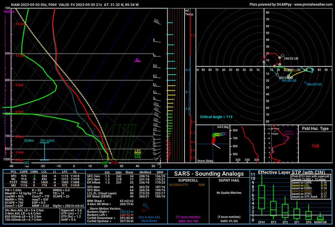
You may catch a strong storm or two. For now, though, it appears that the severe weather threat would be most likely farther north.

Regular storms and rain will be the name of the game, though. with a low-level southerly flow in place, showers and storms will continue. Model estimates shows 2″ to 4″ of rain possible through the end of next week with each passing cluster of storms adding incrementally to the total.
Flooding isn’t looking like much of a concern at the moment, but there may be times when rain is a bit heavy and you see some ponding on roads and in yards.
Today: Sunny. Highs in the lower 80s. Northwest winds 5 to 10 mph.
Tonight: Mostly clear. Lows in the lower 50s. North winds around 5 mph.
Thursday: Sunny. Highs in the mid 80s. East winds around 5 mph, becoming south in the afternoon.
Thursday Night: Mostly cloudy. Not as cool with lows in the lower 60s. South winds around 5 mph.
Friday: Mostly cloudy with storms possible, mainly in the afternoon. Highs in the mid 80s. South winds 5 to 10 mph with gusts up to 20 mph. Chance of rain 40 percent.
Friday Night: Mostly cloudy. Lows in the upper 60s.
Saturday: Partly sunny. A chance of showers and thunderstorms in the afternoon. Highs around 90. Chance of rain 40 percent.
Saturday Night: Partly cloudy in the evening, then becoming mostly cloudy. A slight chance of showers and thunderstorms. Lows in the upper 60s. Chance of rain 20 percent.
Sunday: Partly sunny. A chance of showers and thunderstorms in the afternoon. Highs around 90. Chance of rain 40 percent.
Sunday Night: Mostly cloudy. A slight chance of showers and thunderstorms in the evening. Lows in the upper 60s. Chance of rain 20 percent.
Monday: Mostly cloudy with storms possible, mainly in the afternoon.. Highs in the upper 80s. Chance of rain 40 percent.
Monday Night: Mostly cloudy. Lows in the upper 60s.
Tuesday: Partly sunny. A chance of showers and thunderstorms in the afternoon. Highs in the upper 80s. Chance of rain 40 percent.


