A lot of people have been asking for this for the last few weeks and I’ve been kicking the can down the road waiting for some extra data to come down and I think I’m finally at the point where I feel comfortable giving everyone an early ‘first look’ at what the summer looks like for Louisiana, Mississippi and Alabama.
In a nutshell: Hot. And active.
For more details, keep reading!
ANALOG DATA
Analogs are big in weather. Longtime readers of this website have probably gathered that by now. An analog for weather is just a quick way of saying, “that time it was like this before”
We look at analogs for all kinds of things. the CIPS Analogs, for example, use past events to help us predict upcoming events by looking back and asking, “when did it look like this before, and what happened?”
For seasonal outlooks, I tend to really like analogs because – generally – model guidance doesn’t have much ability to predict things seasonally because there are too many factors at play. So if we can look back and say, “things looked like this before, what happened then?” it can help to guide us toward the correct outcome.
For this forecast we will look at Analogs for ENSO, the Atlantic Ocean warmth, Gulf of Mexico Warmth, Canadian Precipitation.
ENSO
ENSO – or El Nino Southern Oscillation – is the easy one. The analogs there are simply: 2016, 2010, 1998, and 1992

In fact, the only time during the last 50 years that we have had this stout an El Nino and not reverted back to a La Nina the following winter was 1992. Otherwise, we always flip back to LA Nina by the following Winter, which means we are usually pretty Neutral in the summer.
The Atlantic
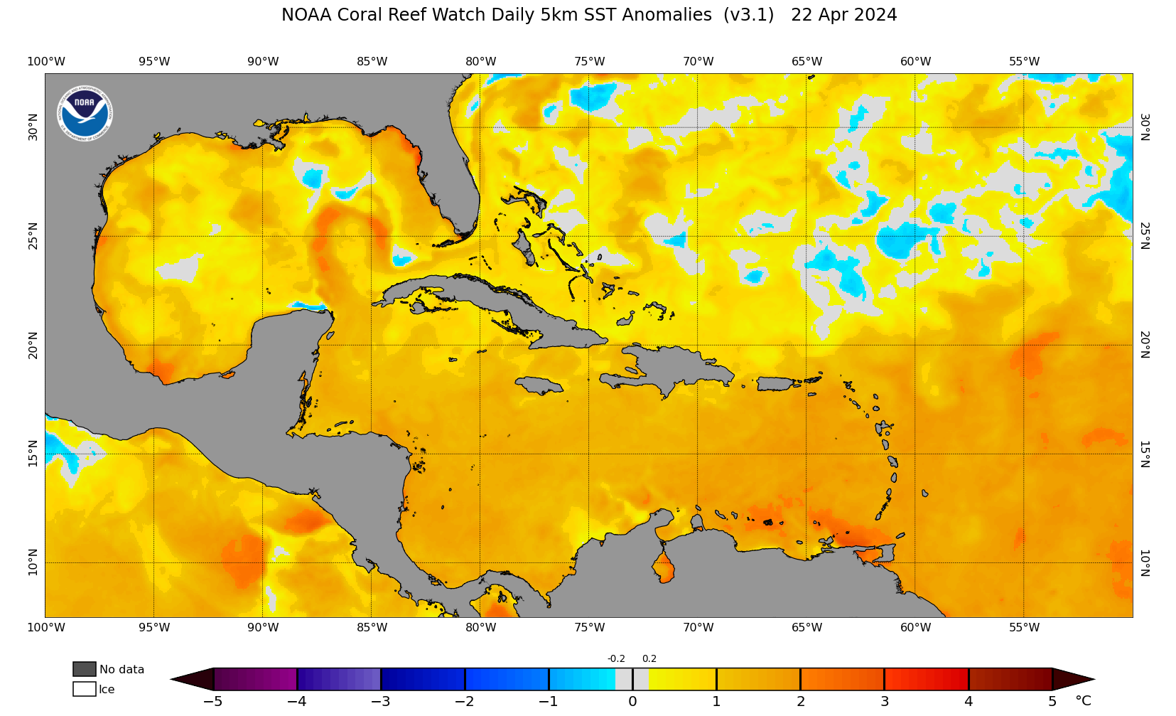
The Atlantic Ocean is very warm. The maps from NOAA really don’t do it justice. Here is one that shows temperatures running 1C to 2.5C above normal across the Main Development Region.

But the overall temperatures across the basin are quite warm compared to history. Brian McNoldy is always monitoring the ocean and has noted that since October 2023 we are very, very warm.
I would point out, “the last time the Atlantic was this warm during this time of the year was _____ but I can’t. Because I don’t know the last time the Atlantic was this warm. It was likely before records were being kept. Like during the Cretaceous.
A warm Atlantic Ocean can mean many things for us locally. The easy one is “hurricanes” but a more nuanced reason to look out into the Atlantic is to get an idea about which direction the wind will be blowing aloft – and will those winds be pointed toward the Gulf.
Gulf of Mexico
The Gulf of Mexico is no different. Hah. Awt.
There are plenty of analogs to this year for sea surface temperatures, but not as many for temperatures to depth. But it is similar enough to the last five years when the Gulf has been bath water.
This can help to keep the humidity up for the area as well as keep overnight lows warmer, too. And the warmer the Gulf is the slower the sea breeze may be on days that aren’t quite as warm over land.
And of course, a warm Gulf means hurricanes will have plenty of food to eat.
Canadian Precip
This one is a big of a wildcard and I know there is only a loose connection, but I looked at Canadian Soil Moisture as a proxy. And things have been generally dry across Canada again.

This may allow for ridging to become more anchored this summer farther north and away from the Gulf Coast. That may allow for more afternoon storms to develop if we aren’t parked underneath a big ridge of high pressure like last year.
SUMMER CONDITIONS
SUMMER TEMPERATURES
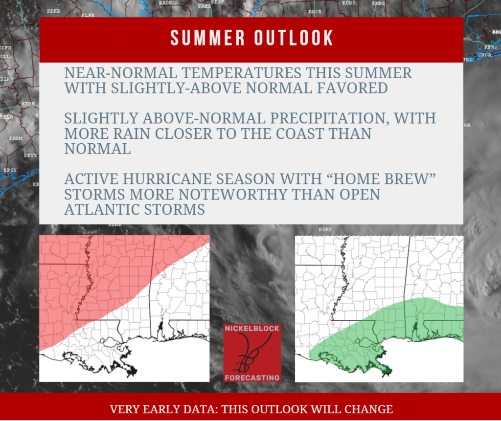
Given all of that, I think this summer looks to be warmer than normal, but not by much. We may quickly springboard into a pretty hot June from a mild May. I also wonder if we see another prolonged severe weather season, too, that lasts into June.
July and August looks to be typically warm. But I think a lot of the threat for above-average temperatures hangs on the overnight lows (given the warm Gulf) than hot afternoon highs.
That means this Summer does not look at brutally hot – nor as dry – as last Summer. Particularly the stretch of 100F-or-warmer days.
SUMMER PRECIPITATION
Given the available data, I think this summer will be slightly wetter than normal – but for the coast by a lot. Inland I think places more than 100 miles from the coast may have a pretty typical Summer, but as you get closer to the Gulf there is a better shot for more precipitation.
This is going to be tied to two things. One, I think the seabreeze may get trapped closer to the coast for longer than it usually does (each day) this Summer. And, two, if we have an active Hurricane Season with a few home brew systems (storms that form close to us in the Gulf), they would bring a shot for extra precipitation to the coast.
HURRICANE SEASON
So, I expect that we will have an active hurricane season. But I think many of the storms that form in the open Atlantic may be less of a concern for us locally. Instead, we may have to watch out for “home brew” storms that develop in the NW Caribbean and Gulf.
The map below highlights areas where we need to monitor for tropical development. The most likely to impact the area in red, second-most likely in orange and third-most as likely in yellow.
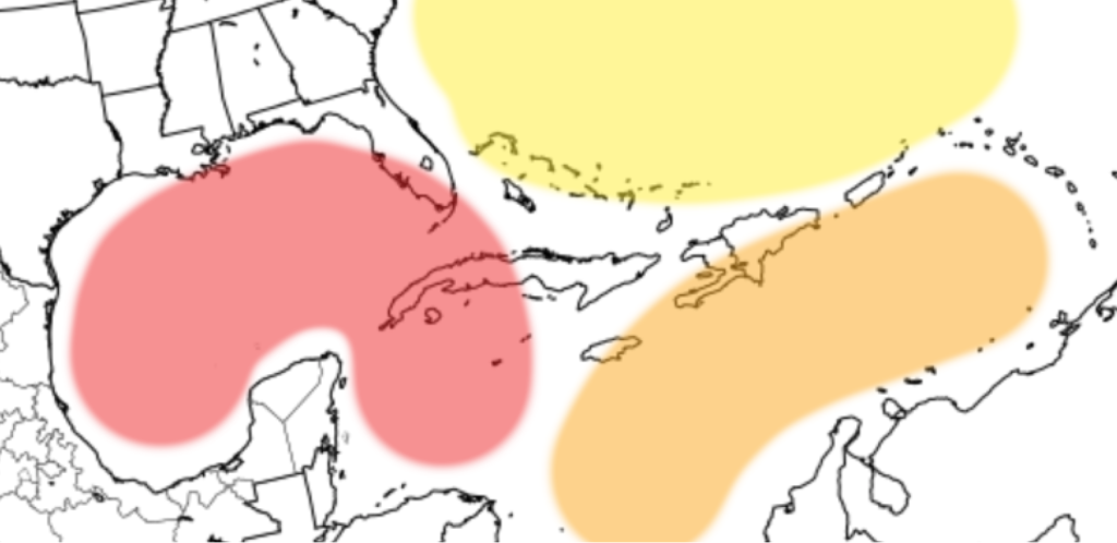
And please don’t get too caught up in the blank areas between these highlighted areas. This is just a simple graphic and is not a full representation of risk.
I think there is one asterisk to the active season. The Atlantic is warm – very warm. But if we slip into a La Nina quickly we may increase the westerlies in the Main Development Region so much that the forward speed of tropical systems may inhibit organization at times. And that may limit how many named storms we get.
BOTTOM LINE
This outlook is likely going to change in the coming months as we get through Spring and into Summer. Often times early Spring is the most difficult time to attempt a seasonal outlook given how much things are still changing.
But, for now, here are the takeaways:


Thanks for update