Hello all and happy Saturday! For today’s CONUS weather outlook, we will be following a usual pattern, by breaking down the CONUS into three sections and then observing the weather for the next week in those areas. At the end will feature a longer range outlook of the general patterns across the country.
We will begin with a 500MB outlook of the entire CONUS in order to see what is going on currently.

Looking at 500MB, two main features immediately jump out from the map. We have a broad upper-level ridge centered over the Rockies near Colorado, and a trough just off the eastern coast. Generally speaking, this would give areas near the ridge hotter and drier weather, whereas areas near the trough could expect more average or even below average temperatures.
Western CONUS
If we start with a breakdown of temperatures expected across the week, our previous theory about above average temperatures is likely to occur.

Looking at the surface temperatures anomalies for the next 3-7 days, we can see much of the west coast is colored in red, meaning above average temperatures are expected throughout the rest of this week and into the next week.
This is also coupled with below average precipitation expected for many areas, besides portions of the desert southwest which is still undergoing monsoon season.

As the map shows, moisture rich air from the Gulf of Mexico and Gulf of California will continue to stream upward towards the Desert Southwest. This is thanks to the ridge being in place to the east of these regions, meaning the flow is mainly southerly. With some regions expected to see 1.5″+ of above average precipitation in an already wet season, flooding issues are a real possibility out west, given the continued chance to see above average rain this week where it has already been wet this season.
Central / Southern CONUS
Moving over into the central and southern CONUS, the story is a little different from out west, where regions are expected to see about average or below average temperatures.

Taking a look at the expected temperatures anomalies over the next 3-7 days, we can see that much of the Great Lakes, Mid-Atlantic, and Ohio Valley region will see below average temperatures. This can be attributed the ridge previously outlined being centered to the west, ushering in cooler air from the north from Canada. Otherwise regions are generally expected to see normal temperatures or slightly above average conditions closer to the south or east you go.
Looking at the precipitation anomalies for the next week, much of the area is expected to see normal precipitation for the week.

There are pockets of wetter and drier areas expected such as those in the Mid-Atlantic receiving higher than average amounts while much of Florida is expected to remain dry.
Northeast CONUS
In the northeast, the heat wave has recently ended and has given way to more comfortable temperatures and humidity across the region. Taking a look at the temperature anomaly map from the previous section, we can see this cooler than average conditions.
As we saw in the first 500MB map, there is a broad trough currently over the northeast and New England, giving way to cooler conditions for the week with increased cloud cover and a cooler airmass making its way over to the region.
Looking at precipitation, the amounts remain mostly light for areas in the northeast.

With portions of the northeast and in particular New England in drought conditions, precipitation is much needed for the area, however not much is expect throughout this next week.
Long-Range Outlook
For the two week outlook, we will look at how temperatures and precipitation will deviate from the average.
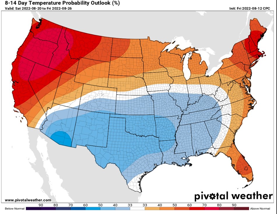
Looking at the 8-14 day temperature probability outlook, the west is expected to continue to see above average temperatures, along with the northeast and Florida. Across the south and southeast, the greatest chances to see below normal temperatures are in the Desert Southwest and into Texas.

For precipitation, much of the CONUS has a relatively low chance at seeing above average precipitation, with better chances across the Mid-Atlantic and into the southeast and Desert Southwest. There is a good chance that the Northern Plains as well as portions of the Pacific Northwest will see below average amounts of precipitation in the long run.


