Another day of rain today with the potential for storms and severe weather. The Storm Prediction Center has increased the Risk to a Slight Risk this morning.

I actually thought they were going to ‘upgrade’ the risk yesterday afternoon, but it looks like they kicked the can down the road to make sure there was a legitimate threat.
All of that said, this is still conditional. We have to wait for an extra push of warmth at the surface and wait and see if the cold air that is undercutting all of this warm and moist air, doesn’t also undercut the updrafts in these storms.
Or, as more verbosely stated by the NWS:
Severe weather: A robust warm sector will quickly become established this morning into the afternoon as mid to upper 60s dewpoints surge into southeast Mississippi ahead of the frontal boundary. Guidance continues to paint impressive thermodynamics for early February with 800-1100 J/kg of MLCAPE across the warm sector. This will be complimented by equally impressive vertical wind shear, especially in the 0-1km layer where bulk shear values will range from 35-45kts with 350-450 m2/s2 of helicity.
The juxtaposition of instability and shear will yield a very favorable parameter space capable of supporting a severe weather episode. The biggest question mark will be storm mode and whether convection can remain surface- based and take advantage of the environment. Forcing will be driven on the mesoscale by the arctic front and weak surface convergence while upper height tendencies remain neutral within the broad southwest flow regime. If storms are anchored along the arctic front they would tend to get undercut by the surging cold air and would pose little to no severe threat.
However, the 00z suite of CAM guidance is in fairly good agreement that at least some of the convection may be able to remain surface-based just ahead of the frontal boundary owing to enough of a component of the deep-layer shear vector oriented off the boundary. In addition, a few isolated storms may develop ahead of the main line of convection in the open warm sector.
Given these trends, have upgraded the HWO/graphics in conjunction with SPC to include a slight risk across southeast Mississippi for a tornado and damaging wind threat.
Given all of the parameters in place, though, the SPC has decided to go with the Slight Risk across parts of Louisiana, Mississippi and Alabama.

The Slight Risk actually lines up pretty well with what the HREF computer weather model was showing for the area with the highest chance for the most Updraft Helicity.
Below is the UH Streaks map. Recall that these Updraft Helicity streaks are when we let the computers try to find where they think the rotating storms will develop, given the parameters expected to be in place.

One thing to keep in mind is that if the cold air completely undercuts the storms, that renders all of this spinning useless for producing any kind of severe weather. So while this looks robust, because we are in a conditional situation, it may look worse than it actually ends up being.
Karrie Meter
Not much movement here since last night. Even the hi-res guidance is mostly unchanged. The Karrie Meter is up a whopping 0.01. The thing that held it from being up a bit higher is two things, the GFS/ECMWF computer weather models are unimpressed with the instability. This is understandable, though, as they are not made to pick up on the tiny details that the RAP, HRRR and NAM models are designed to see.
Karrie Meter: 4.30
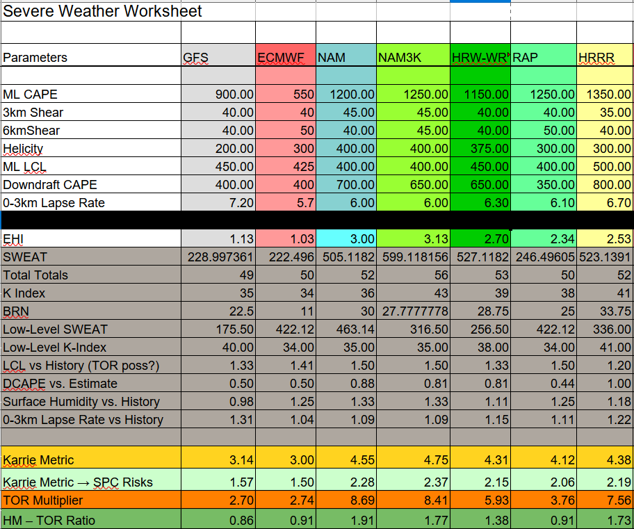
The one thing I’d also like to note is the “TOR Multiplier” section and the “Ratio” below it. This is looking at specific parameters that research has shown increase (or decrease) the potential for tornadoes to develop. I then took those parameters and checked for local thresholds. After running through a quick bit of basic math, it gave me a meaningful number.
Any time the TOR Multiplier number is higher than the Karrie Meter it means tornadoes are more likely to occur than if the number is lower than the Karrie Meter. And the ratio is a quick measure of that.
So in the above graphic, four of the severe models show a ratio larger than “1” and three show a number smaller than “1” which lends to the conditional nature of our surface-based severe weather threat. It is almost a 50-50 shot.
The difference is the ratio numbers that are smaller than “1” are barely smaller while the numbers greater than “1” are much higher. So it lends credence to a true threat for severe weather, and in this case, the potential for tornadoes.
Bottom Line: Timeline & Threats
So far, it looks like despite the new information increasing the potential intensity of storms, not much has changed to the overall forecast from this morning. There has been a slight shift in the timeline, though, as it looks like storms may pick up about an hour or so faster than I was thinking this morning.
8a-10a — Showers and storms developing, very few may be strong to severe. Main threats with any storm will be heavy rain, frequent lightning, gusty wind, small hail, and a tornado can not be ruled out.
10a-2p — Showers and storms likely, some strong and a few may be severe. Main threats with stronger storms will be very heavy rain, frequent lightning, wind gusts up to 60mph, hail up to the size of quarters, and the potential for a tornado (up to EF2 in strength)
2p-6p — Showers and storms likely, some strong and very few severe. Main threats with stronger storms will be very heavy rain, frequent lightning, wind gusts up to 60mph, hail up to the size of quarters, and the potential for a tornado (up to EF2 in strength)
6p-10p — Showers and storms ending. Few remaining storms will be strong, very few, if any, will be severe. Main threats with any storm will be heavy rain, frequent lightning, gusty wind, small hail, and a tornado can not be ruled out.
The peak timeline for the potential for the strongest storms is still looking like around the lunch hour and into the early afternoon, depending on your location.
Combining the Timeline and the Karrie Meter, you get a graph that shows your highest risk for the strongest storms. And it looks like the “Marginal Risk” starts around 10a and we get to a “Slight Risk” around noon. Then we stay there through about 5p. Then things really die off after that point.

The main concern with storms today will be heavy rain, brief flash flooding, frequent lightning wind gusts up to 65mph, hail up to the size of quarters, and the potential for a tornado or two (up to EF2 in strength)
Most folks will see just heavy rain, gusty wind and lightning. But keep an eye to the sky, just in case you are one of the few people who gets stuck underneath one of the stronger storms.
On top of all of this, there is also the chance for 2″ to 4″ of rainfall. That may lead to some localized flash flooding. So if there is water across the road while you’re driving around tomorrow, please don’t try to drive through the water, and find another way around. You never know what is – or is not – underneath floodwaters.
Day-to-Day Forecast
Thursday
Cloudy with storms possible. Some severe. Breezy. Highs in the mid 70s. South winds 10 to 20mph with gusts to near 30mph. About a 100 percent chance for rain.
Thursday Night
Cloudy with storms lingering until midnight. Turning colder. Still breezy. Lows in the upper 30s. Northwest winds around 10mph gusting to 20mph. The chance of rain 60-percent.
Friday
Still cloudy with a few showers possible. Still breezy. Cooler. Highs in the mid 40s. North winds 10 to 15mph. Chance for rain around 20-percent.
Friday Night
Clearing skies. Lows in the lower 30s.
Saturday
Mostly sunny. Highs around 50.
Saturday Night
Mostly clear. Lows in the upper 20s.
Sunday
Sunny. Highs in the upper 50s.
Sunday Night
Partly cloudy. Lows in the lower 30s.
Monday
Partly cloudy. Highs in the mid 50s.
Monday Night
Mostly clear. Lows around 30.
Tuesday
Mostly sunny. Highs in the mid 50s.
Tuesday Night
Partly cloudy. Lows in the lower 30s.
Wednesday
Partly cloudy. Highs around 60.


