I had some time this morning to break away from work to help break down the forecast a bit further. I got a request for one of these county-by-county breakdowns, and I thought I would do my best to provide it.
This one may not be as detailed as some have been int he past, but hopefully it will help give you an diea about what to expect.
Here is a look at the latest outlooks from the Storm Prediction Center:


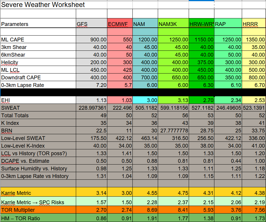
And an hour-by-hour graph of the Karrie Meter as well as the latest numbers:

Today is a pretty big conditional threat day. That means most folks will only see heavy rain, rumbles of thunder and some gusty wind. Only a few folks have a chance to see any severe storms. And that is going to be dictated by a few key parameters.
Thankfully today isn’t looking like a widespread severe weather day. But keep an eye to the sky.
Louisiana
St. Helena Parish
8a-10a — Showers and storms developing, very few may be strong to severe. Main threats with any storm will be heavy rain, frequent lightning, gusty wind, small hail, and a tornado can not be ruled out.
10a-2p — Showers and storms likely, some strong and a few may be severe. Main threats with stronger storms will be very heavy rain, frequent lightning, wind gusts up to 60mph, hail up to the size of quarters, and the potential for a tornado (up to EF2 in strength).
2p-6p — Showers and storms ending. Few remaining storms will be strong, very few, if any, will be severe. Main threats with any storm will be heavy rain, frequent lightning, gusty wind, small hail, and a tornado can not be ruled out.
6p-10p — Turning colder and windy.
Tangipahoa Parish
8a-10a — Showers and storms developing, very few may be strong to severe. Main threats with any storm will be heavy rain, frequent lightning, gusty wind, small hail, and a tornado can not be ruled out.
10a-2p — Showers and storms likely, some strong and a few may be severe. Main threats with stronger storms will be very heavy rain, frequent lightning, wind gusts up to 60mph, hail up to the size of quarters, and the potential for a tornado (up to EF2 in strength).
2p-6p — Showers and storms ending. Few remaining storms will be strong, very few, if any, will be severe. Main threats with any storm will be heavy rain, frequent lightning, gusty wind, small hail, and a tornado can not be ruled out.
6p-10p — Turning colder and windy.
Washington Parish
8a-10a — Showers and storms developing, very few may be strong to severe. Main threats with any storm will be heavy rain, frequent lightning, gusty wind, small hail, and a tornado can not be ruled out.
10a-2p — Showers and storms likely, some strong and a few may be severe. Main threats with stronger storms will be very heavy rain, frequent lightning, wind gusts up to 60mph, hail up to the size of quarters, and the potential for a tornado (up to EF2 in strength).
2p-6p — Showers and storms ending. Few remaining storms will be strong, very few, if any, will be severe. Main threats with any storm will be heavy rain, frequent lightning, gusty wind, small hail, and a tornado can not be ruled out.
6p-10p — Turning colder and windy.
Livingston Parish
8a-10a — Showers and storms developing, very few may be strong to severe. Main threats with any storm will be heavy rain, frequent lightning, gusty wind, small hail, and a tornado can not be ruled out.
10a-2p — Showers and storms likely, some strong and a few may be severe. Main threats with stronger storms will be very heavy rain, frequent lightning, wind gusts up to 60mph, hail up to the size of quarters, and the potential for a tornado (up to EF2 in strength).
2p-6p — Showers and storms ending. Few remaining storms will be strong, very few, if any, will be severe. Main threats with any storm will be heavy rain, frequent lightning, gusty wind, small hail, and a tornado can not be ruled out.
6p-10p — Turning colder and windy.
St. Tammany Parish
8a-10a — Showers and storms developing, very few may be strong to severe. Main threats with any storm will be heavy rain, frequent lightning, gusty wind, small hail, and a tornado can not be ruled out.
10a-2p — Showers and storms likely, some strong and a few may be severe. Main threats with stronger storms will be very heavy rain, frequent lightning, wind gusts up to 60mph, hail up to the size of quarters, and the potential for a tornado (up to EF2 in strength).
2p-6p — Showers and storms ending. Few remaining storms will be strong, very few, if any, will be severe. Main threats with any storm will be heavy rain, frequent lightning, gusty wind, small hail, and a tornado can not be ruled out.
6p-10p — Turning colder and windy.
Mississippi
NEAR I-20
Copiah County
8a-10a — Showers and storms developing, very few may be strong to severe. Main threats with any storm will be heavy rain, frequent lightning, gusty wind, small hail, and a tornado can not be ruled out.
10a-2p — Showers and storms likely, some strong and a few may be severe. Main threats with stronger storms will be very heavy rain, frequent lightning, wind gusts up to 60mph, hail up to the size of quarters, and the potential for a tornado (up to EF2 in strength).
2p-6p — Showers and storms ending by 6p, but some may be strong and a few may be severe. Main threats with stronger storms will be very heavy rain, frequent lightning, wind gusts up to 60mph, hail up to the size of quarters, and the potential for a tornado (up to EF2 in strength).
6p-10p — Turning colder and windy.
Simpson County
8a-10a — Showers and storms developing, very few may be strong to severe. Main threats with any storm will be heavy rain, frequent lightning, gusty wind, small hail, and a tornado can not be ruled out.
10a-2p — Showers and storms likely, some strong and a few may be severe. Main threats with stronger storms will be very heavy rain, frequent lightning, wind gusts up to 60mph, hail up to the size of quarters, and the potential for a tornado (up to EF2 in strength).
2p-6p — Showers and storms ending by 6p, but some may be strong and a few may be severe. Main threats with stronger storms will be very heavy rain, frequent lightning, wind gusts up to 60mph, hail up to the size of quarters, and the potential for a tornado (up to EF2 in strength).
6p-10p — Turning colder and windy.
Smith County
8a-10a — Showers and storms developing, very few may be strong to severe. Main threats with any storm will be heavy rain, frequent lightning, gusty wind, small hail, and a tornado can not be ruled out.
10a-2p — Showers and storms likely, some strong and a few may be severe. Main threats with stronger storms will be very heavy rain, frequent lightning, wind gusts up to 60mph, hail up to the size of quarters, and the potential for a tornado (up to EF2 in strength).
2p-6p — Showers and storms ending by 6p, but some may be strong and a few may be severe. Main threats with stronger storms will be very heavy rain, frequent lightning, wind gusts up to 60mph, hail up to the size of quarters, and the potential for a tornado (up to EF2 in strength).
6p-10p — Turning colder and windy.
Jasper County
8a-10a — Showers and storms developing, very few may be strong to severe. Main threats with any storm will be heavy rain, frequent lightning, gusty wind, small hail, and a tornado can not be ruled out.
10a-2p — Showers and storms likely, some strong and a few may be severe. Main threats with stronger storms will be very heavy rain, frequent lightning, wind gusts up to 60mph, hail up to the size of quarters, and the potential for a tornado (up to EF2 in strength).
2p-6p — Showers and storms ending by 6p, but some may be strong and a few may be severe. Main threats with stronger storms will be very heavy rain, frequent lightning, wind gusts up to 60mph, hail up to the size of quarters, and the potential for a tornado (up to EF2 in strength).
6p-10p — Turning colder and windy.
Clarke County
8a-10a — Showers and storms developing, very few may be strong to severe. Main threats with any storm will be heavy rain, frequent lightning, gusty wind, small hail, and a tornado can not be ruled out.
10a-2p — Showers and storms likely, some strong and a few may be severe. Main threats with stronger storms will be very heavy rain, frequent lightning, wind gusts up to 60mph, hail up to the size of quarters, and the potential for a tornado (up to EF2 in strength).
2p-6p — Showers and storms likely, some strong and very few severe. Main threats with stronger storms will be very heavy rain, frequent lightning, wind gusts up to 60mph, hail up to the size of quarters, and the potential for a tornado (up to EF2 in strength)
6p-10p — Showers and storms ending. Few remaining storms will be strong, very few, if any, will be severe. Main threats with any storm will be heavy rain, frequent lightning, gusty wind, small hail, and a tornado can not be ruled out.
HIGHWAY 84 CORRIDOR
Lincoln County
8a-10a — Showers and storms developing, very few may be strong to severe. Main threats with any storm will be heavy rain, frequent lightning, gusty wind, small hail, and a tornado can not be ruled out.
10a-2p — Showers and storms likely, some strong and a few may be severe. Main threats with stronger storms will be very heavy rain, frequent lightning, wind gusts up to 60mph, hail up to the size of quarters, and the potential for a tornado (up to EF2 in strength).
2p-6p — Showers and storms ending by 6p, but some may be strong and a few may be severe. Main threats with stronger storms will be very heavy rain, frequent lightning, wind gusts up to 60mph, hail up to the size of quarters, and the potential for a tornado (up to EF2 in strength).
6p-10p — Turning colder and windy.
Lawrence County
8a-10a — Showers and storms developing, very few may be strong to severe. Main threats with any storm will be heavy rain, frequent lightning, gusty wind, small hail, and a tornado can not be ruled out.
10a-2p — Showers and storms likely, some strong and a few may be severe. Main threats with stronger storms will be very heavy rain, frequent lightning, wind gusts up to 60mph, hail up to the size of quarters, and the potential for a tornado (up to EF2 in strength).
2p-6p — Showers and storms ending by 6p, but some may be strong and a few may be severe. Main threats with stronger storms will be very heavy rain, frequent lightning, wind gusts up to 60mph, hail up to the size of quarters, and the potential for a tornado (up to EF2 in strength).
6p-10p — Turning colder and windy.
Jeff Davis County
8a-10a — Showers and storms developing, very few may be strong to severe. Main threats with any storm will be heavy rain, frequent lightning, gusty wind, small hail, and a tornado can not be ruled out.
10a-2p — Showers and storms likely, some strong and a few may be severe. Main threats with stronger storms will be very heavy rain, frequent lightning, wind gusts up to 60mph, hail up to the size of quarters, and the potential for a tornado (up to EF2 in strength).
2p-6p — Showers and storms likely, some strong and very few severe. Main threats with stronger storms will be very heavy rain, frequent lightning, wind gusts up to 60mph, hail up to the size of quarters, and the potential for a tornado (up to EF2 in strength)
6p-10p — Showers and storms ending. Few remaining storms will be strong, very few, if any, will be severe. Main threats with any storm will be heavy rain, frequent lightning, gusty wind, small hail, and a tornado can not be ruled out.
Covington County
8a-10a — Showers and storms developing, very few may be strong to severe. Main threats with any storm will be heavy rain, frequent lightning, gusty wind, small hail, and a tornado can not be ruled out.
10a-2p — Showers and storms likely, some strong and a few may be severe. Main threats with stronger storms will be very heavy rain, frequent lightning, wind gusts up to 60mph, hail up to the size of quarters, and the potential for a tornado (up to EF2 in strength).
2p-6p — Showers and storms likely, some strong and very few severe. Main threats with stronger storms will be very heavy rain, frequent lightning, wind gusts up to 60mph, hail up to the size of quarters, and the potential for a tornado (up to EF2 in strength)
6p-10p — Showers and storms ending. Few remaining storms will be strong, very few, if any, will be severe. Main threats with any storm will be heavy rain, frequent lightning, gusty wind, small hail, and a tornado can not be ruled out.
Jones County
8a-10a — Showers and storms developing, very few may be strong to severe. Main threats with any storm will be heavy rain, frequent lightning, gusty wind, small hail, and a tornado can not be ruled out.
10a-2p — Showers and storms likely, some strong and a few may be severe. Main threats with stronger storms will be very heavy rain, frequent lightning, wind gusts up to 60mph, hail up to the size of quarters, and the potential for a tornado (up to EF2 in strength).
2p-6p — Showers and storms likely, some strong and very few severe. Main threats with stronger storms will be very heavy rain, frequent lightning, wind gusts up to 60mph, hail up to the size of quarters, and the potential for a tornado (up to EF2 in strength)
6p-10p — Showers and storms ending. Few remaining storms will be strong, very few, if any, will be severe. Main threats with any storm will be heavy rain, frequent lightning, gusty wind, small hail, and a tornado can not be ruled out.
Wayne County
8a-10a — Showers and storms developing, very few may be strong to severe. Main threats with any storm will be heavy rain, frequent lightning, gusty wind, small hail, and a tornado can not be ruled out.
10a-2p — Showers and storms likely, some strong and a few may be severe. Main threats with stronger storms will be very heavy rain, frequent lightning, wind gusts up to 60mph, hail up to the size of quarters, and the potential for a tornado (up to EF2 in strength)..
2p-6p — Showers and storms likely, some strong and very few severe. Main threats with stronger storms will be very heavy rain, frequent lightning, wind gusts up to 60mph, hail up to the size of quarters, and the potential for a tornado (up to EF2 in strength)
6p-10p — Showers and storms ending by 10p. some strong and very few severe. Main threats with stronger storms will be very heavy rain, frequent lightning, wind gusts up to 60mph, hail up to the size of quarters, and the potential for a tornado (up to EF2 in strength)
HIGHWAY 98 CORRIDOR
Pike County
8a-10a — Showers and storms developing, very few may be strong to severe. Main threats with any storm will be heavy rain, frequent lightning, gusty wind, small hail, and a tornado can not be ruled out.
10a-2p — Showers and storms likely, some strong and a few may be severe. Main threats with stronger storms will be very heavy rain, frequent lightning, wind gusts up to 60mph, hail up to the size of quarters, and the potential for a tornado (up to EF2 in strength).
2p-6p — Showers and storms ending by 6p, but some may be strong and a few may be severe. Main threats with stronger storms will be very heavy rain, frequent lightning, wind gusts up to 60mph, hail up to the size of quarters, and the potential for a tornado (up to EF2 in strength).
6p-10p — Turning colder and windy.
Walthall County
8a-10a — Showers and storms developing, very few may be strong to severe. Main threats with any storm will be heavy rain, frequent lightning, gusty wind, small hail, and a tornado can not be ruled out.
10a-2p — Showers and storms likely, some strong and a few may be severe. Main threats with stronger storms will be very heavy rain, frequent lightning, wind gusts up to 60mph, hail up to the size of quarters, and the potential for a tornado (up to EF2 in strength).
2p-6p — Showers and storms ending by 6p, but some may be strong and a few may be severe. Main threats with stronger storms will be very heavy rain, frequent lightning, wind gusts up to 60mph, hail up to the size of quarters, and the potential for a tornado (up to EF2 in strength).
6p-10p — Turning colder and windy.
Marion County
8a-10a — Showers and storms developing, very few may be strong to severe. Main threats with any storm will be heavy rain, frequent lightning, gusty wind, small hail, and a tornado can not be ruled out.
10a-2p — Showers and storms likely, some strong and a few may be severe. Main threats with stronger storms will be very heavy rain, frequent lightning, wind gusts up to 60mph, hail up to the size of quarters, and the potential for a tornado (up to EF2 in strength).
2p-6p — Showers and storms likely, some strong and very few severe. Main threats with stronger storms will be very heavy rain, frequent lightning, wind gusts up to 60mph, hail up to the size of quarters, and the potential for a tornado (up to EF2 in strength)
6p-10p — Showers and storms ending. Few remaining storms will be strong, very few, if any, will be severe. Main threats with any storm will be heavy rain, frequent lightning, gusty wind, small hail, and a tornado can not be ruled out.
Lamar County
8a-10a — Showers and storms developing, very few may be strong to severe. Main threats with any storm will be heavy rain, frequent lightning, gusty wind, small hail, and a tornado can not be ruled out.
10a-2p — Showers and storms likely, some strong and a few may be severe. Main threats with stronger storms will be very heavy rain, frequent lightning, wind gusts up to 60mph, hail up to the size of quarters, and the potential for a tornado (up to EF2 in strength).
2p-6p — Showers and storms likely, some strong and very few severe. Main threats with stronger storms will be very heavy rain, frequent lightning, wind gusts up to 60mph, hail up to the size of quarters, and the potential for a tornado (up to EF2 in strength)
6p-10p — Showers and storms ending. Few remaining storms will be strong, very few, if any, will be severe. Main threats with any storm will be heavy rain, frequent lightning, gusty wind, small hail, and a tornado can not be ruled out.
Forrest County
8a-10a — Showers and storms developing, very few may be strong to severe. Main threats with any storm will be heavy rain, frequent lightning, gusty wind, small hail, and a tornado can not be ruled out.
10a-2p — Showers and storms likely, some strong and a few may be severe. Main threats with stronger storms will be very heavy rain, frequent lightning, wind gusts up to 60mph, hail up to the size of quarters, and the potential for a tornado (up to EF2 in strength).
2p-6p — Showers and storms likely, some strong and very few severe. Main threats with stronger storms will be very heavy rain, frequent lightning, wind gusts up to 60mph, hail up to the size of quarters, and the potential for a tornado (up to EF2 in strength)
6p-10p — Showers and storms ending. Few remaining storms will be strong, very few, if any, will be severe. Main threats with any storm will be heavy rain, frequent lightning, gusty wind, small hail, and a tornado can not be ruled out.
Perry County
8a-10a — Showers and storms developing, very few may be strong to severe. Main threats with any storm will be heavy rain, frequent lightning, gusty wind, small hail, and a tornado can not be ruled out.
10a-2p — Showers and storms likely, some strong and a few may be severe. Main threats with stronger storms will be very heavy rain, frequent lightning, wind gusts up to 60mph, hail up to the size of quarters, and the potential for a tornado (up to EF2 in strength).
2p-6p — Showers and storms likely, some strong and very few severe. Main threats with stronger storms will be very heavy rain, frequent lightning, wind gusts up to 60mph, hail up to the size of quarters, and the potential for a tornado (up to EF2 in strength)
6p-10p — Showers and storms ending. Few remaining storms will be strong, very few, if any, will be severe. Main threats with any storm will be heavy rain, frequent lightning, gusty wind, small hail, and a tornado can not be ruled out.
Greene County
8a-10a — Showers and storms developing, very few may be strong to severe. Main threats with any storm will be heavy rain, frequent lightning, gusty wind, small hail, and a tornado can not be ruled out.
10a-2p — Showers and storms developing, very few may be strong to severe. Main threats with any storm will be heavy rain, frequent lightning, gusty wind, small hail, and a tornado can not be ruled out.
2p-6p — Showers and storms likely, some strong and very few severe. Main threats with stronger storms will be very heavy rain, frequent lightning, wind gusts up to 60mph, hail up to the size of quarters, and the potential for a tornado (up to EF2 in strength)
6p-10p — Showers and storms ending by 10p. some strong and very few severe. Main threats with stronger storms will be very heavy rain, frequent lightning, wind gusts up to 60mph, hail up to the size of quarters, and the potential for a tornado (up to EF2 in strength)
HIGHWAY 26 CORRIDOR
Pearl River County
8a-10a — Showers and storms developing, very few may be strong to severe. Main threats with any storm will be heavy rain, frequent lightning, gusty wind, small hail, and a tornado can not be ruled out.
10a-2p — Showers and storms likely, some strong and a few may be severe. Main threats with stronger storms will be very heavy rain, frequent lightning, wind gusts up to 60mph, hail up to the size of quarters, and the potential for a tornado (up to EF2 in strength).
2p-6p — Showers and storms ending. Few remaining storms will be strong, very few, if any, will be severe. Main threats with any storm will be heavy rain, frequent lightning, gusty wind, small hail, and a tornado can not be ruled out.
6p-10p — Turning colder and windy.
Stone County
8a-10a — Showers and storms developing, very few may be strong to severe. Main threats with any storm will be heavy rain, frequent lightning, gusty wind, small hail, and a tornado can not be ruled out.
10a-2p — Showers and storms likely, some strong and a few may be severe. Main threats with stronger storms will be very heavy rain, frequent lightning, wind gusts up to 60mph, hail up to the size of quarters, and the potential for a tornado (up to EF2 in strength).
2p-6p — Showers and storms likely, some strong and very few severe. Main threats with stronger storms will be very heavy rain, frequent lightning, wind gusts up to 60mph, hail up to the size of quarters, and the potential for a tornado (up to EF2 in strength)
6p-10p — Showers and storms ending. Few remaining storms will be strong, very few, if any, will be severe. Main threats with any storm will be heavy rain, frequent lightning, gusty wind, small hail, and a tornado can not be ruled out.
George County
8a-10a — Showers and storms developing, very few may be strong to severe. Main threats with any storm will be heavy rain, frequent lightning, gusty wind, small hail, and a tornado can not be ruled out.
10a-2p — Showers and storms developing, very few may be strong to severe. Main threats with any storm will be heavy rain, frequent lightning, gusty wind, small hail, and a tornado can not be ruled out.
2p-6p — Showers and storms likely, some strong and very few severe. Main threats with stronger storms will be very heavy rain, frequent lightning, wind gusts up to 60mph, hail up to the size of quarters, and the potential for a tornado (up to EF2 in strength)
6p-10p — Showers and storms ending by 10p. some strong and very few severe. Main threats with stronger storms will be very heavy rain, frequent lightning, wind gusts up to 60mph, hail up to the size of quarters, and the potential for a tornado (up to EF2 in strength)
COASTAL MISSISSIPPI
Jackson County
8a-10a — Showers and storms developing, very few may be strong to severe. Main threats with any storm will be heavy rain, frequent lightning, gusty wind, small hail, and a tornado can not be ruled out.
10a-2p — Showers and storms developing, very few may be strong to severe. Main threats with any storm will be heavy rain, frequent lightning, gusty wind, small hail, and a tornado can not be ruled out.
2p-6p — Showers and storms likely, some strong and very few severe. Main threats with stronger storms will be very heavy rain, frequent lightning, wind gusts up to 60mph, hail up to the size of quarters, and the potential for a tornado (up to EF2 in strength)
6p-10p — Showers and storms ending by 10p. some strong and very few severe. Main threats with stronger storms will be very heavy rain, frequent lightning, wind gusts up to 60mph, hail up to the size of quarters, and the potential for a tornado (up to EF2 in strength)
Harrison County
8a-10a — Showers and storms developing, very few may be strong to severe. Main threats with any storm will be heavy rain, frequent lightning, gusty wind, small hail, and a tornado can not be ruled out.
10a-2p — Showers and storms developing, very few may be strong to severe. Main threats with any storm will be heavy rain, frequent lightning, gusty wind, small hail, and a tornado can not be ruled out.
2p-6p — Showers and storms likely, some strong and very few severe. Main threats with stronger storms will be very heavy rain, frequent lightning, wind gusts up to 60mph, hail up to the size of quarters, and the potential for a tornado (up to EF2 in strength)
6p-10p — Showers and storms ending by 10p. some strong and very few severe. Main threats with stronger storms will be very heavy rain, frequent lightning, wind gusts up to 60mph, hail up to the size of quarters, and the potential for a tornado (up to EF2 in strength)
Hancock County
8a-10a — Showers and storms developing, very few may be strong to severe. Main threats with any storm will be heavy rain, frequent lightning, gusty wind, small hail, and a tornado can not be ruled out.
10a-2p — Showers and storms developing, very few may be strong to severe. Main threats with any storm will be heavy rain, frequent lightning, gusty wind, small hail, and a tornado can not be ruled out.
2p-6p — Showers and storms likely, some strong and very few severe. Main threats with stronger storms will be very heavy rain, frequent lightning, wind gusts up to 60mph, hail up to the size of quarters, and the potential for a tornado (up to EF2 in strength)
6p-10p — Showers and storms ending by 10p. some strong and very few severe. Main threats with stronger storms will be very heavy rain, frequent lightning, wind gusts up to 60mph, hail up to the size of quarters, and the potential for a tornado (up to EF2 in strength)
Alabama
Sumter County
8a-10a — Showers and storms developing, very few may be strong to severe. Main threats with any storm will be heavy rain, frequent lightning, gusty wind, small hail, and a tornado can not be ruled out.
10a-2p — Showers and storms developing, very few may be strong to severe. Main threats with any storm will be heavy rain, frequent lightning, gusty wind, small hail, and a tornado can not be ruled out.
2p-6p — Showers and storms likely, some strong and very few severe. Main threats with stronger storms will be very heavy rain, frequent lightning, wind gusts up to 60mph, hail up to the size of quarters, and the potential for a tornado (up to EF2 in strength)
6p-10p — Showers and storms likely, but severe threat ending by 10p, some strong and very few severe. Main threats with stronger storms will be very heavy rain, frequent lightning, wind gusts up to 60mph, hail up to the size of quarters, and the potential for a tornado (up to EF2 in strength)
Choctaw County
8a-10a — Showers and storms developing, very few may be strong to severe. Main threats with any storm will be heavy rain, frequent lightning, gusty wind, small hail, and a tornado can not be ruled out.
10a-2p — Showers and storms developing, very few may be strong to severe. Main threats with any storm will be heavy rain, frequent lightning, gusty wind, small hail, and a tornado can not be ruled out.
2p-6p — Showers and storms likely, some strong and very few severe. Main threats with stronger storms will be very heavy rain, frequent lightning, wind gusts up to 60mph, hail up to the size of quarters, and the potential for a tornado (up to EF2 in strength)
6p-10p — Showers and storms likely, but severe threat ending by 10p, some strong and very few severe. Main threats with stronger storms will be very heavy rain, frequent lightning, wind gusts up to 60mph, hail up to the size of quarters, and the potential for a tornado (up to EF2 in strength)
Washington County
8a-10a — Showers and storms developing, very few may be strong to severe. Main threats with any storm will be heavy rain, frequent lightning, gusty wind, small hail, and a tornado can not be ruled out.
10a-2p — Showers and storms developing, very few may be strong to severe. Main threats with any storm will be heavy rain, frequent lightning, gusty wind, small hail, and a tornado can not be ruled out.
2p-6p — Showers and storms likely, some strong and very few severe. Main threats with stronger storms will be very heavy rain, frequent lightning, wind gusts up to 60mph, hail up to the size of quarters, and the potential for a tornado (up to EF2 in strength)
6p-10p — Showers and storms likely, but severe threat ending by 10p, some strong and very few severe. Main threats with stronger storms will be very heavy rain, frequent lightning, wind gusts up to 60mph, hail up to the size of quarters, and the potential for a tornado (up to EF2 in strength)


