Howdy!
Currently temperatures are in the high 80s and lower 90s and some rain out in central/east Alabama and the Florida Panhandle. More rain and thunderstorms are expected to develop as the day progresses for the rest of the region.
Looking at the 500mb height pattern for the next couple of days, there is a difference between what is occurring today and what will occur Monday night into Tuesday that is important. Today, we still have that ridge over us, but looking at the right map (for Monday night), that trough to the northeast has pushed into the region.
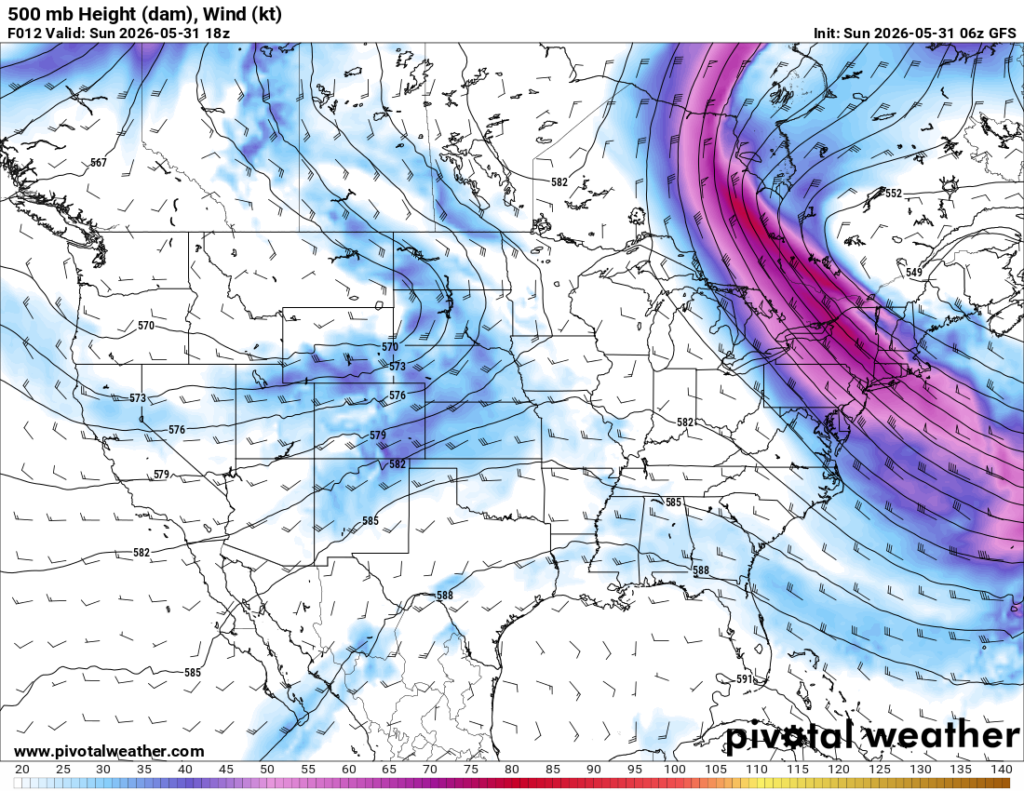
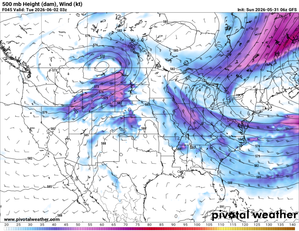
From the left to the right map, we can see that the trough becomes more neutrally tilted, which can serve as an indicator of weather development east of the trough into our region. Height contours (black lines) are tightening, which indicates the strengthening of mid-level flow and can support ascending air and instability.
This pattern is a good set up to see some severe storms and possibly an MCS move through the region Monday evening into Tuesday. Main concerns from this would be damaging winds. Several models point to this, including the HRRR run below.
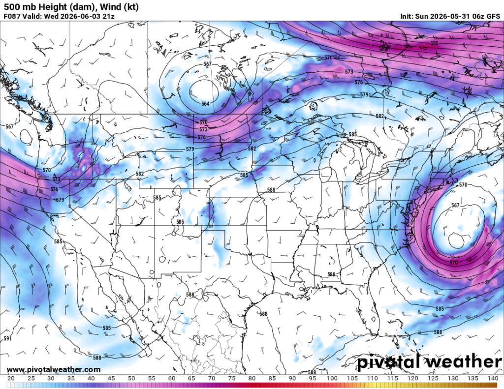
Later in the week, a broad ridge will again be present over our region, high pressure aloft. We are expected to have a slight cool down of temperatures to the mid 80s for the high by Wednesday and Thursday as a weak back door cold front comes through. Enjoy the little bit of relief that will bring! Below we can see that broad ridge that will take over later this week.
3-DAY TRAVEL FORECAST
AIRPORTS
KIAH / KHOU (Houston) – A chance of showers and thunderstorms Monday and Tuesday in the afternoon. Main concern is lightning delays. Most flights should not be delayed especially in the morning/early afternoon.
KSHV (Shreveport) – Mostly clear for the next couple of days, 20% chance of showers and thunderstorms on Tuesday afternoon, so delays related to lightning can occur.
KBTR (Baton Rouge) – A chance of showers and thunderstorms each day in the afternoon, largest chance on Tuesday. There is possibility of lightning delays for flights later in the day.
KJAN (Jackson) – Slight chances of rain each day in the afternoon, greatest on Tuesday at 20%. Delays are possible with any lightning.
KMSY (New Orleans) – Chance of showers and thunderstorms for Monday and Tuesday in the afternoon, greatest on Tuesday at 50%. Lightning delays are possible.
KMOB (Mobile) – Afternoon showers and thunderstorms are possible for the next three days. Lightning delays are possible especially for afternoon flights.
KATL (Atlanta) – Slight chance of showers per day in the afternoon, 30% for each day. Delays are possible for each day due to any lightning and hazardous flying conditions.
KTLH (Tallahassee) – Chance of showers and thunderstorms per day. Monday has chances in the morning, other days with chances in the afternoon. Delays possible with lightning for afternoon and before/after 8am on Monday.
KBHM (Birmingham) – Chance for showers and thunderstorms each day, Sunday (today) at 80% all after 1pm. Monday’s chances after 10am at 40%, then afternoon chances on Tuesday. Greatest chance of delays are today, but delays are possible for each day with any lightning.
HIGHWAYS
I-10 – Pop up showers and thunderstorms occurring in Alabama and the Florida Panhandle are the greatest risk for I-10 later in the day today. Showers are possible each day with the possibility of that MCS on Monday night stretching through Mississippi and Alabama, so keep updated.
I-20 – Showers and thunderstorms possible each day along I-20 especially in Alabama, so be aware of that. Traveling through Mississippi also at risk of any afternoon showers. Look out for Monday into Tuesday.
I-49 – Good driving conditions overall, some isolated showers can pop up east of I-49 for the next few days. There are no significant storm chances.
I-55 – Showers and thunderstorms possible in the afternoon, convective development later on today especially along the coast, so be aware of that. Greatest risk on Monday evening with the possibility of the MCS system moving through Mississippi and Alabama, might fall apart before reaching the coast.
I-59 – Pop up showers and thunderstorms possible the next couple of days especially in the afternoon, main chances in Alabama along I-59 and the chance of the storm system moving in Monday evening is something to look out for.
I-65 – Main risk is along the coast with convection development later today and evenings for the next few days. Heading into Montgomery, can experience those pop-up thunderstorms starting in the afternoon.
I-75 – Lots of chances of rain for central Georgia into this evening and into Florida. If you are traveling from Georgia into Florida, look out for increased convection and scattered showers/thunderstorms starting around noon into tonight.
CITY FORECASTS
Houston, TX
Today/Tonight – Calm winds from the southeast around 5mph, hot with a high near 93. Partly cloudy skies with an increase in clouds tonight. Low is around 76. No chance of rain for today and tonight.
Monday – There is a 20% chance of showers and thunderstorms after 1pm. The high will also be around 93 and partly cloudy skies. Calm winds from the southeast. Low is around 76 with partly cloudy skies.
Tuesday – After 1pm, there is a 30% chance of showers and thunderstorms. High will be around 93 with mostly sunny skies, calm winds from the east around 5mph.
Shreveport, LA
Today/Tonight – Sunny skies and hot, high near 94 and winds from the south around 5mph. Tonight will be mostly clear skies with a low around 76, winds still from the south and calm.
Monday – Another hot day with a high around 95 and mostly sunny skies. Winds from the southwest around 5 mph. Make sure to keep hydrated as the heat index will reach over 100. Monday night will be mostly clear and a low around 75.
Tuesday – There is a 20% chance of showers and thunderstorms in the afternoon. Other than that, it will be sunny and hot, a high near 93. Winds are light, and will shift to the northeast in the afternoon.
Baton Rouge, LA
Today/Tonight – Warm today with a high of 91, calm winds and mostly sunny skies. Tonight, the low is around 75 and winds from the south around 5 mph. Partly cloudy skies.
Monday – There is a 30% chance of showers and thunderstorms in the evening after 5pm. High around 91 and a low around 74, the chance of showers and thunderstorms continuing into the overnight hours.
Tuesday – 50% chance of showers and thunderstorms in the afternoon. Besides that, mostly sunny skies and a high around 92. Winds shift to the north in the afternoon. Low is around 72, precipitation potential continuing overnight.
Jackson, MS
Today/Tonight – There is a slight chance of showers and thunderstorms today after 5pm and before 4pm at 20%. Hot, with a high near 91 and heat index reaching about 100. Low around 74 with a 10% chance of showers tonight.
Monday – Hot and sunny with a high of 92. Winds shift to west northwest in the afternoon. Monday night, there is a 20% chance of showers and thunderstorms and a low at 73 with calm winds.
Tuesday – Slight chance of showers and thunderstorms in the afternoon, mostly sunny skies with a high near 90. Winds are light from the northwest and shifting northward throughout the day. Low around 68.
New Orleans, LA
Today/Tonight – A high around 90 and calm winds from the south and mostly sunny skies. The low tonight will be around 78 and winds still from the south, shifting to the west.
Monday – A chance of showers and thunderstorms in the late afternoon, at 30%, mostly sunny with a high of 89. Winds shift from the north in the afternoon. The low is around 75.
Tuesday – There is a 50% chance of showers and thunderstorms in the early afternoon into the evening. High is near 89 and mostly sunny skies during the day. Low is 75 with the chances of rain continuing overnight.
Mobile, AL
Today/Tonight – Keep that umbrella with you as there is a 40% chance of showers and thunderstorms today in the afternoon (mainly before 4pm). Partly cloudy skies are expected and a high around 90. Tonight, rain chances continue and the low will be around 74. Winds from the southwest around 5 mph.
Monday – Another chance for rain on Monday at 40% in the afternoon. The day will start pretty cloudy and become gradually sunny, high reaching 93. The low will fall around 73, winds shifting from the northwest overnight.
Tuesday – Again, 40% chance of showers and thunderstorms in the afternoon. Other than that, expect mostly sunny skies and a high near 92. Winds are from the northwest around 5 mph. The low will be around 70.
Atlanta, GA
Today/Tonight – Around a 40% chance of showers and thunderstorms later today, a high around 75 and gusty conditions, up to 20 mph. Tonight, there are more rain chances and a low around 65. Winds calm down overnight.
Monday – The day will start off mostly cloudy, then chances for rain later in the afternoon at 30%. The high will be around 84 and wind gusts can reach 15 mph. Low is around 67, chances of rain overnight.
Tuesday – Chance of showers and thunderstorms is 40%, greatest potential after 2pm. High will be around 83 and winds from the northeast around 5-10 mph. Low is 60 and there are no chances for rain overnight.
Tallahassee, FL
Today/Tonight – Afternoon showers are possible later today, so keep that umbrella handy! High is near 90 with partly sunny skies. Winds from the south around 5-10 mph. Low is around 74. Tonight, there are chances of rain overnight, mainly between 11 pm and 2 am.
Monday – It will be pretty warm with potential for rain in the morning before 8am and then again later in the day. The day will start pretty cloudy, then become more sunny with a high near 92. The low falls to 74 with no rain potential overnight.
Tuesday – Afternoon showers and thunderstorms are possible at 50%. It will be mostly sunny before that and the high will reach 93. Winds are from the northwest at 5-10 mph. The low will be around 70, and there will be overnight chances of rain.
Birmingham, AL
Today/Tonight – It will be a wet one today out in Birmingham, chances of precipitation at 80%. Make sure to take that umbrella and be safe out on the roads! Winds are calm throughout the day. Tonight, precipitation will continue overnight, tenth of an inch rain accumulation is possible throughout the day. The low falls around 67.
Monday – Partly sunny skies with a high near 87, chances of rain throughout the day especially in the early afternoon. Low is around 68 and winds are calm. Precipitation potential increases overnight at around 50%.
Tuesday – The high will reach 86 with mostly sunny skies. There is a chance of afternoon showers and thunderstorms, chance of 20%. Winds increase in speed throughout the day and are from the north. The low will be around 62 and mostly clear skies overnight.


