After a relatively long break for late May, widespread severe weather has returned to the central great plains. Large hail, damaging winds and potentially a few tornadoes will be possible from Montana to Texas this evening.
Down in our neck of the woods, it actually looks to be fairly quiet. Sure there may be an isolated thunderstorm or two but most locations might actually get a break from last week’s deluge.
Severe weather chances look fairly low (but not zero) with the exception of Monday. There is a chance that central Mississippi may get clipped by more organized convective cluster. This would mean a damaging wind threat along with the usual risks of heavy rain and frequent lightning. Again, this is not a guarantee but just something to keep an eye on.
The main storyline for the next few days will be the heat. It will definitely feel like summer through Tuesday as the ridge aligns itself more with the deep South. Try to avoid spending much time outside during the peak heating hours and take frequent breaks and hydrate if you must.

Tonight
It should be a pretty calm evening across the area. Most of the remaining showers and storms are currently dissipating with the loss of daytime heating. Temperatures will only fall into the lower 70s due to the excessive amount of moisture in the air.
This moisture (combined with the lack of surface winds) will allow for potentially dense fog to develop. Be extra cautious in river valleys and low lying areas.
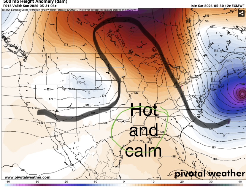
The lack of any significant storms is due to the upper level pattern. Right now we are under what is known as an omega block. This keeps the jet stream (and associated lift and shear for storms) far away. Above is a dome of hot air that is slowly sinking keeping our area hot and humid but free from big bad storms.
Tomorrow
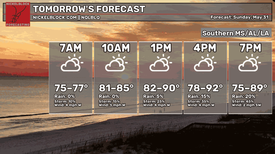
Most of the region will get into the 90s by tomorrow afternoon. Clouds will gradually build through the morning and someone will probably get a thunderstorm by 4pm but it’s uncertain exactly who. The storms will be isolated and very slow moving but still capable of very heavy rain and frequent lightning (we also cannot rule out a very localized area of strong winds as the storms collapse).
Dewpoints will be in the upper 70s and maybe even the low 80s. This will create distinct muggyness in the air that will make it unpleasant to be outside for any portion of time. Heat indexes will likely be over 100 degrees so it will definitely feel like summer out there.
Try to wear lighter clothing and take breaks in the AC often if you are required to be outside. On the bright side, it will be a great day to go swimming and chill by the pool.

The Day after Tomorrow
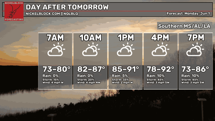
Monday will be another hot and very humid day. Due to the high dewpoints, heat indexes will again reach dangerous levels so make sure to limit your time outside as much as possible.
The precipitation forecast is more complicated. What we know for sure is that there will be a few pulse thunderstorms somewhere in the area. While most people would stay dry, some areas may experience heavy rain and lightning.
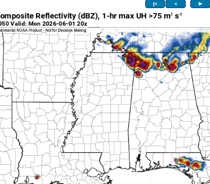
The difficult part is the potential for an mcs to sink southeast from the remnants of Sundays convection. If this did occur, it would likely be over northern Mississippi but these complexes have a tendency to end up further south than expected. It most likely won’t impact our area but it’s something to keep an eye on. If it does occur, the mcs will capable of widespread damaging winds along with heavy rain and lightning.

The Extended Range
A typical summertime pattern will likely work its way into the deep South as we move into early June. That means gross heat and humidity along with a chance of afternoon showers and storms every day.
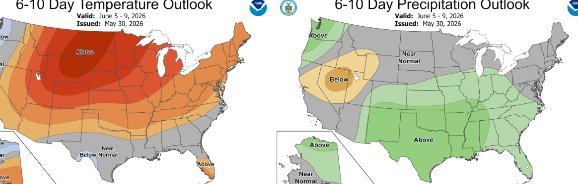
There isn’t anything eye catching in the long ranges that says something big will happen. It will rain some days in some areas and be very muggy a lot.
Thankfully, it does not appear that there will be any massive heat domes or giant severe weather outbreaks in the pipe so it’ll mostly be business as usual.
In terms of good news, the recent rain has put a major dent in the drought and any rain that does occur will help reinforce the soil moistening.
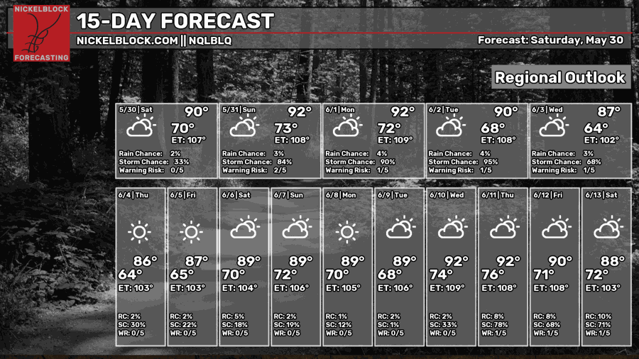
Day-by-Day Forecast
Tonight- Calm wind with a low in the low 70s. Patchy fog.
Tomorrow- Partly sunny with a chance of afternoon thunderstorms. Highs in the low 90s with heat index values over 100 .
Tomorrow night- Partly cloudy with a low in the low 70s. Thunderstorms diminishing in the evening with a chance of fog around sunrise.
Monday- Mostly sunny with a slight chance of afternoon thunderstorms. Highs in the low 90s with heat indexes well over 100.
Monday Night- Partly cloudy with a low in the low 70s. Humid with a chance of fog.
Tuesday- Increasing clouds with a high in the low 90s. Humid with a slight chance of afternoon thunderstorms.
Tuesday night- A bit cooler with lows in the upper 60s. Partly cloudy.
Wednesday- Mostly sunny with highs in the mid 80s. Chance for afternoon thunderstorms.
Wednesday Night- Mostly clear and calm. Lows in the mid 60s.
Thursday- Partly sunny with highs in the upper 80s. Chance for afternoon thunderstorms.
Thursday Night- Partly cloudy and calm. Lows in the mid 60s.
Friday- Partly sunny with highs in the upper 80s. Scattered thunderstorms in the afternoon.
Friday Night- Decreasing clouds as storms diminish. Lows in the upper 60s.


