Stop me if you’ve heard this one: Severe weather threat for south Mississippi will be overnight.
As we head into Friday night it looks like another round of storms will press through the area. Storms will pack heavy rain, frequent lightning, wind gusts up to 60mph, hail up to the size of nickels, and the potential to produce a few brief tornadoes.
All of this is associated with a little area of low pressure that is set to kick out from the Southern Plains on Friday. As it passes through the Gulf Coast region, it will march a line of storms from east Texas all the way to South Carolina.

From the SPC
The SPC has actually highlighted both Friday and Saturday with the potential for severe weather for southern Mississippi.


Both days feature either a Marginal or Slight risk for severe weather. That is a “1” and a “2” on the 1-to-5 scale where “5” is the highest risk for the most significant severe weather.
The SPC Discussion:
A south-southwesterly low-level jet is forecast to strengthen considerably from east TX into LA and southern MS Friday evening/night. Surface-based convection appears increasingly probable across this area as low-level moisture quickly increases. The EML may advect eastward over this region, and NAM forecast soundings show a favorable thermodynamic and kinematic environment to support organized severe thunderstorms along/south of the warm front.
All hazards, including tornadoes, will be possible through Friday night into early Saturday morning.
The best severe threat may be focused with the eastward-developing low-level jet, but additional severe storms along the cold front may also occur. Even with this seemingly favorable setup for severe thunderstorms, the potential exists for afternoon storms with low-level warm advection to slow the northward advance of the warm front and limit instability. Once uncertainty regarding the evolution of these afternoon storms is better resolved, greater severe probabilities for tornadoes may need to be included for parts of the Sabine River Valley vicinity.
Courtesy: spc.noaa.gov
The quick mention of the low-level jet, LLJ, is interesting and something I had not double-checked the LLJ before tonight. But it is worth noting that is will be cranking across parts of the Gulf Coast region within the model guidance.
The Karrie Meter
The Karrie MEter map from the NAM model looks more ominous than things will – likely – end up materializing. This is because one of the pieces that goes into making the map is running very “hot” within the data, so it is giving inflated numbers.
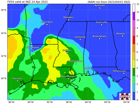
For example, the two red bullseyes that creep northeast through northern Mississippi and Alabama are probably not going to be much of a problem for severe weather due to the lack of low-level support for severe storms.
What the Karrie Meter is seeing is a lot of spin in the atmosphere as well as some mid-level instability and it is kicking back some rather high numbers because of that.
But, as of now, it appears that toward the surface, the temperature profile may not support surface-based severe weather. And thus the tornado threat should be minimized – up there.
Farther south, it looks to be a solid sea of greens and yellows. This lines up with what the SPC is suggesting, too. So both the Karrie Meter and the SPC are on the same page.
The Bottom Line
So far, what we know is that there will be the chance for storms and the potential for severe weather between 9p Friday night and 9a on Saturday morning. Storms may pack heavy rain, frequent lightning, wind gusts up to 60mph, hail up to the size of nickels and the potential to produce a few brief tornadoes.
Beyond that, specifics are hard to come by at this point because we are just starting to get within the window where model data is precise enough and accurate enough to offer worthwhile projections.
For now, just make sure to have your NOAA Weather radio nearby and programmed on Friday night. Download an app for your phone that will ping you when a warning is issued for your area. And keep tabs on the forecast during the next 48 hours as things will potentially change with the timeline, threats, and potency of the storms.


Thank you Nick!