11:30AM UPDATE FROM THE SPC:
The SPC has introduced a corridor of Enhanced Risk for some of the western counties of south Mississippi.

Along with this discussion update:
…Southeast TX into LA/MS/AL this evening and tonight…
A strong southerly low-level jet is forecast to develop after dark across far southeast TX and southern LA. This will help to focus lift and shear along precipitation-reinforced boundary that will extend across the region.
Most CAM solutions show multiple bow/supercell structures tracking along the boundary through the evening and overnight into parts of southern MS/AL. Present indications are that damaging winds will be the main threat with these storms. However, there is increasing concern for a greater tornado risk as well – both supercellular and QLCS.
Will maintain 5% tornado probabilities at this time but may introduce higher probabilities at 20z if confidence of the narrow corridor of threat increases.
Courtesy: spc.noaa.gov
ORIGINAL:
It just hit me: This is likely going to be my last post on my blog made as an employee of WDAM. Honestly, that doesn’t mean much. It is symbolic, sure. But it doesn’t really mean anything.
Though, if I know Mother Nature, it probably means that whatever I forecast here will be rendered meaningless by her sense of humor. With my luck and with Mother Nature’s history, tomorrow will be, like, 85 and sunny after I go through and forecast storms. Ha!
From the SPC
The Storm Prediction Center has maintained the Slight Risk for south Mississippi.

The main concern will be heavy rain, frequent lightning, wind gusts up to 65mph, hail up to the size of quarters, and the potential for a few brief tornadoes (up to EF-2 in strength).
Here is their latest discussion:
…Synopsis…
An active, progressive mid/upper-level flow belt will exist across most of the CONUS through the period, south of a substantial cyclone covering most of mainland Nunavut. The key feature for this forecast is a pronounced trough — evident in moisture-channel imagery initially from the Four Corners area south-southwestward across AZ, Sonora, and central/southern Baja. This trough should become somewhat less positively tilted today, as it progresses to western KS, the TX Panhandle/South Plains, and the Big Bend area by 00Z.
The trough should reach western MO, eastern OK and the middle TX Coast by the end of the period. At the surface, 11Z analysis showed an elongated area of low pressure in a frontal zone across parts of eastern CO, western KS, the OK and northern TX Panhandles, and northeastern NM. The low should consolidate and deepen through today over the TX Panhandle and northeast TX, then move roughly eastward near the Red River toward TX overnight. The trailing cold front will move southeastward across northwest and west-central TX, while the frontal segment northeast of the low also shifts southeastward over OK. Meanwhile, a marine/warm front initially drawn over south TX and just offshore LA will shift northward over central/north TX today, into southern and perhaps central OK this evening, as well as parts of east TX and LA, modulated on the mesoscale by extensive convection forecast to develop along and north of the boundary.
A dryline will become more sharply defined across the Permian Basin, South Plains and Panhandle today, mixing eastward over the Edwards Plateau, Concho Valley and Big Country regions today, while hanging up some nearer the surface low over northwest TX.
…Southern Plains to portions of MS…
Multiple episodes of strong-severe thunderstorms are possible through the period, with some spatial overlap between each of them accounting for the aggregate shape of the outlook area. Two regimes will account for the bulk of severe potential with these episodes: 1. Central TX to MS and central OK: A large area of scattered to numerous thunderstorms should form and grow throughout the midday to late-afternoon period over central/east TX, with a lobe potentially extending across portions of north-central TX into at least central OK.
Thunderstorms should aggregate and shift eastward across the east TX Piney Woods, LA and the lower Mississippi Valley. Expect mainly a damaging-wind threat, with a few tornadoes also possible from embedded heavy-precip supercells and QLCS mesocirculations.
Without the optimally steep lapse rates and buoyant profiles of areas farther west, and with messier storm modes, only sporadic large hail is likely from east TX eastward . However, relatively early and more westward in the episode, severe to significant (2+ inch diameter) hail will be possible as well from supercells.
This activity will develop gradually but expansively and be supported by:
a) Gently sloping, warm-frontal lift;
b) A broad area of low-level warm advection and moisture transport ahead of the mid/upper trough;
c) Favorable vertical shear/CAPE parameter spaces, with 500-1500 J/kg MLCAPE spreading northeastward near the warm/marine frontal zone, enlarged hodographs in the frontal zone, and 40-55 kt effective-shear magnitudes in forecast soundings not convectively contaminated;
d) Weakened MLCINH/MUCINH through warm-advection-related lift along and east of the eastern rim of the EML.This convection should shift eastward across the lower Mississippi Valley tonight, with considerable uncertainty remaining on the northern (instability) and eastern (timing) edges of the severe threat in particular.
Courtesy: spc.noaa.gov
The uncertainty with timing is a big one for south Mississippi because the longer it takes to get here the closer it may move through the area at daybreak which would help to limit the overall threat for severe weather (a little) given that the atmosphere naturally stabilizes around dawn.
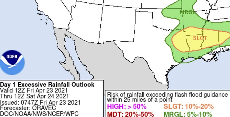
The flooding threat
Right now it also looks like there may be a brief window for some localized flash flooding to occur across parts of the area overnight and into Saturday morning.
A big swatch of rain is suggested to build into the area overnight followed by a tail of training storms into Saturday morning. This may lead to a localized corridor near Highway 98 that may see up to 5-to-6 inches of rain.
Given the already-wet ground and the already-swollen rivers this may lead to some brief localized flash flooding in some areas. The WPC has also highlighted parts of the area with a Slight Risk for flash flooding.
At this point, it doesn’t look like any kind of massive flooding event where entire neighborhoods are underwater. But this may be a situation where water may rise along some creeks and streams, water may pond in your yard, and it may even cover up some low-lying roads forcing you to find another way around.
Model Data
I talked about the Effective Inflow Layer last night during my facebook video and I’d like to touch on that again because I think it will play a role in how the severe threat materializes for our area.
The Effective Inflow Layer, according to the SPC, is “the first layer in a sounding where all contiguous lifted parcels have CAPE >= 100 J kg-1 and CIN >= -250 J kg-1. The effective inflow layer is meant to represent the inflow layer for a thunderstorm.”
The idea is that this is the section of the atmosphere where air that is being pulled into the thunderstorm has enough instability and a lower amount of inhibition. The effective inflow layer technique is applicable to both surface-based and elevated thunderstorms. And it is a good first “eye-balling it” indicator for a true tornado risk.
Let’s take a look at a sounding for 10pm Friday night:
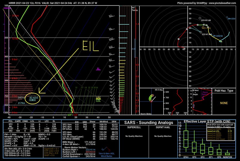
As you can see the Effective Inflow Layer, EIL, in this case is between the “850” line and the “700” line on the sounding chart.
FOR MORE INFORMATION OF READING ON OF THESE SKEW-T CHARTS, CHECK THIS OUT!
That means that the EIL is elevated and the ‘first’ area in the thunderstorms inflow that has inability and lower inhibition is not based at the ground. That will limited (a ton) the threat for storms at this point to produce a tornado.
But it doesn’t stay that way.

By 2am, you can see that the EIL is now on the ‘other side’ of that “850” line and thus closer to the ground. This means that the area in the storms where air is being pulled into the updraft is also closer to the ground.
By 3am, it is getting pretty close.

That, likely, means that the tornado potential for the region won’t likely materialize until around 3am. But even then it won’t be a widespread concern, but instead it will be dictated on a storm-by-storm basis. Some storms will have access to an EIL that may be a bit closer to the ground that other storms.
It will just, in a sense, depend on the storm.
But by 7am… the EIL is at the surface.
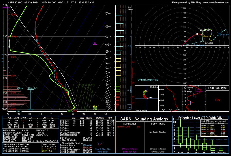
You can also see the progression of the potential in the “PSBL HAZ. TYPE” box in the lower right corner of each image. We go from “NONE” to “TOR” while the EIL gets closer to the surface.
Now, keep in mind, this isn’t the only thing we look at. It just so happens that in this particular scenario it helps highlight the potential for tornadoes a bit better.
Semi-related, I would argue that even at 7am, there will still be a bit of an inversion in place, and tornadoes can’t form in an inversion (that I am aware of, at least). So, even at this point, I think the tornado threat will remain on the low end of the scale.
Timeline & Threats
Right now it looks like the first rain will press into the area around 9pm Friday night. But the threat for severe weather won’t begin until closer to 1am Saturday morning. That threat for severe weather will continue through about 7am on Saturday morning before storms move east into Alabama. Rain should come to an end around 10am.
The main concern within most storms will be heavy rain, frequent lightning, wind gusts up to 50mph, and hail up to the size of pennies.
The concern for the few strongest storms will be heavy rain, frequent lightning, wind gusts up to 65mph, hail up to the size of quarters, and the potential for a brief tornado (up to EF-2 in strength)
If – and this is a big if – a storm or two can develop in the warm sector and be isolated and on their own, the potential for larger hail may manifest. And the potential for a tornado to stay on the ground a big longer may also develop.
But that is a big if at this point.
The Bottom Line
Storms will be moving through the area overnight. There is a potential for a tornado or two. But there is a greater potential for heavy rain and very gusty wind.
Either way – given how wet the ground is and the additional rain that is coming – trees won’t do well in this round of storms. So if you live on some land with trees around your home, please keep an eye (and an ear) out for those.
Rainfall totals across the area will be between 1″ and 3″ with a streak (near or along the Highway 98 corridor) of up to 6″ of rain possible.
The threat for storms begins around 9pm Friday night and ends around 7am Saturday morning.
Have your NOAA Weather Radio programmed correctly and turned on to alert you, have a good weather app on your phone that will alert you when a warning is issued, and head to bed tonight. This shouldn’t be the kind of event that necessitates you staying up all night long. Just make sure that ringer is on really loud, and you should be okay.


Hi Nick. You are correct. I learned a lot about weather from watching you on WDAM, and felt your delivery was crisp and clear. You’re my guy when it comes to severe weather here in Laure, MS. You will be missed.