Hey guys! It’s your favorite weather intern Emily here bringing a new addition to your daily weather indulgence. As if you hadn’t read enough from me yet, I’m now beginning to do article reviews in addition to my weekly forecasts. I will be reading through some papers with various topics that all relate to operational forecasting or radar meteorology and include some studies that take a closer look at severe weather.
Here’s a look at the break-down for these reviews:
- What the article talked about
- How it helps the further development of meteorological practices
- Three things I would have liked to have seen be further discussed or investigated (within the chosen article)
Take a look at what I learned while reading, “An Integrated Approach for Assessing Tropical Cyclone Track and Intensity Forecasts” by Wenqing Zhang, Lian Xie, Bin Liu, and Changlong Guan.
In Summary…
This article focuses on the error found within tropical cyclone forecasts and their adapted proposal to eliminate corruptible variables. The authors begin by defining key terms such as intensity forecast, tropical cyclone size, size error, and tropical cyclone track.
After defining these terms, the authors explain their motivations for research as an “individual-parameter evaluation approach” and the faults that prevent this method from being optimized in terms of performance. They find the approach to be “unambiguous and unified assessment for TC forecasts” (970), “used at the same time, and may provide conflicting assessment results” (970), and “interdependent, especially when a TC makes landfall” (971).
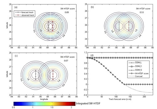
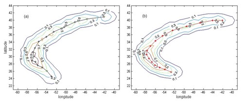
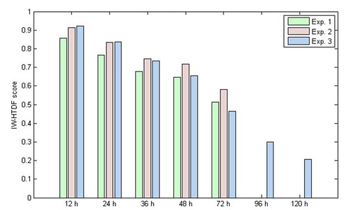
After providing the comparison to that which we currently use in the weather world today, they establish a thesis of designing a “new evaluation criterion for assessing TC forecasts” (971). They explain the creation of the IW-HTDF (Intensity-Weighted Hurricane Track Density Function) and provide the calculations as well as their formulas that were utilized throughout the study to provide comparative data with the various storms studied. Furthermore, by using modern examples of storms and their collected data, the article gives great detail into their method of combining the track, intensity, and size of tropical cyclones in cross reference with the errors found within their forecasts.
Within several charts and graphs provided, data is broken down into similar conditions and values. As with many good research studies, the authors relay issues with their proposal by claiming their project doesn’t account for overlapping data, sensitive and simple algorithms, and the multiple variables that could be combined into one for ease and accuracy within the calculations. The article then enters a discussion subject regarding other methods of forecast analysis for tropical cyclones and a response as to why these methods that are already in place are faulty.
Various issues include the inability to combine certain variables into one equation, and finding a value system for further analysis. Finally, the authors conclude with a statement claiming that, “the advantages of the IW-HTDF – based forecast verification are twofold: providing an integrated track, intensity, and size forecast skill score for each TC forecast, thus avoiding the confusion arising from contradictory assessments among track, intensity, and size forecasts when they are evaluated separately, and providing a unique assessment of forecast or model performance based on the two-dimensional spatial similarity of all three facets or TC forecasts , namely, track, intensity, and size, rather than examining the forecast along a single forecast track” (987).
How it helps…
This study helps to further development in the meteorological modern practices by bringing attention to the faulty method of assessment for tropical cyclone forecasts that is used today. They suggest that more lives and property could be saved if there was a closer look at size, track, and intensity within each storm before the report is submitted.
By doing so, meteorologists would be given more accurate data to then release to he public to give more updated and accurate information. Their study suggests that by combining means of assessment into one factor could eliminate minor errors in calculations. This would allow for more concise information and specific results.
What I want to know…
It would be great to know about alternative methods and why those calculations make them unfit for accurate analysis. Also, what determined which storms would be used in their research. And it would be nice to see the comparative data showing occasions when the forecast was accurate and lacked errors.
And finally…
This article is a great read if your in the mood to examine the process in which scientists classify hurricanes. I find the article very intriguing in the sense that it left me wondering how scientists can accurately combine certain variables such as intensity (qualitative) and size (quantitative) into one calculation and how errors are still being found within such intricate calculations that are designed to avoid bad data. However, as I was taught in class, many calculations follow the saying bad data in leads to bad data out. Regardless, the authors that published this did a wonderful job in providing a well rounded study and I enjoyed reading their findings.


