Tropical Storm Bertha is anticipated to make landfall this evening near the central Louisiana coast as a tropical storm with wind speeds of around 46 mph.
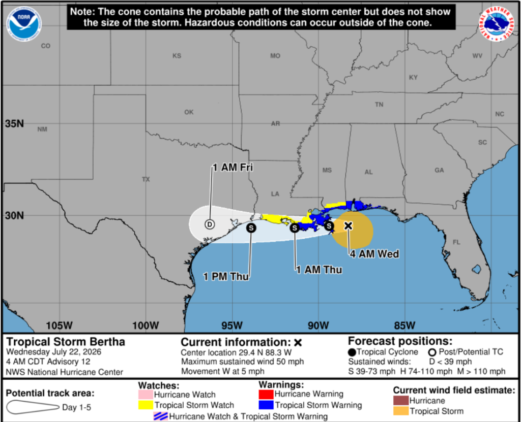
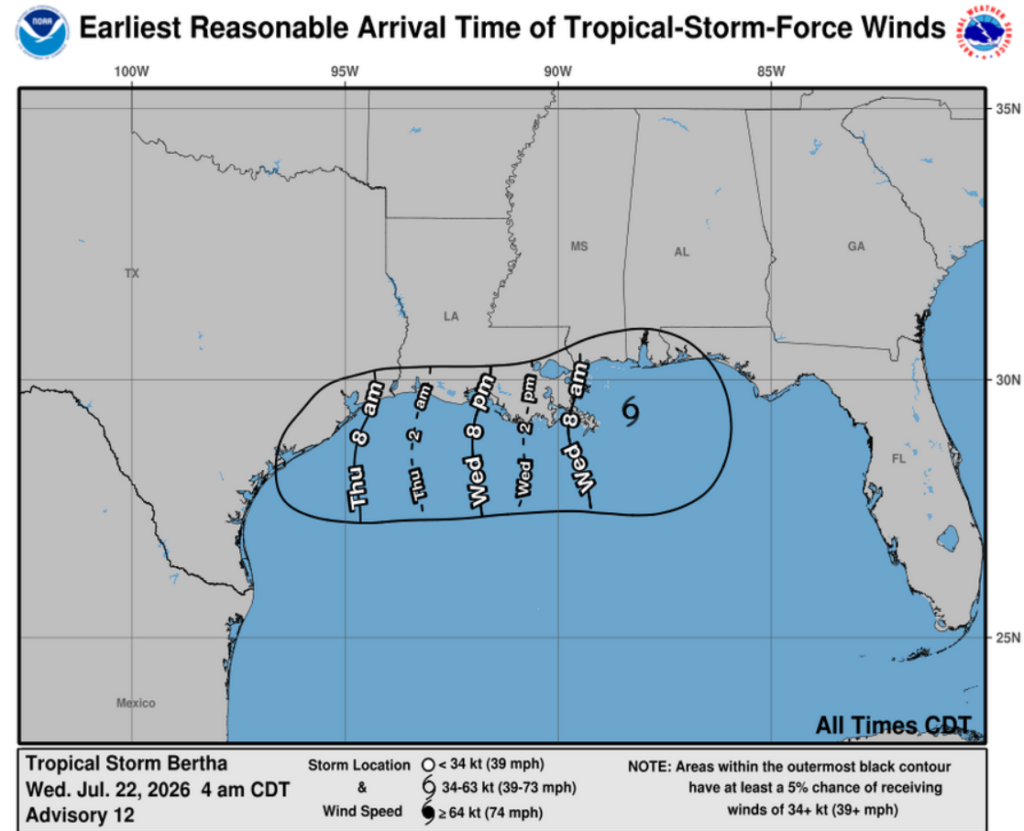
Tropical Storm Bertha is currently located about 110 miles west-southwest of Panama City, Florida, moving west at a little less than 6mph. Bertha has maximum sustained winds of 58 mph, with gusts up to 69 mph, and a minimum central pressure of 995 mb. Below are the anticipated times of arrival for these tropical-storm-force winds.
Bertha remains a sheared tropical storm, with its low-level center exposed and most of its deep convection/storms displaced to the southwest of the storm due to strong wind shear. This is good news, as wind shear typically tears the storm apart and prevents it from strengthening. This storm is expected to continue moving generally westward through Friday, tracking near or along the northern Gulf Coast. Gradual weakening is expected to begin today before landfall later tonight.
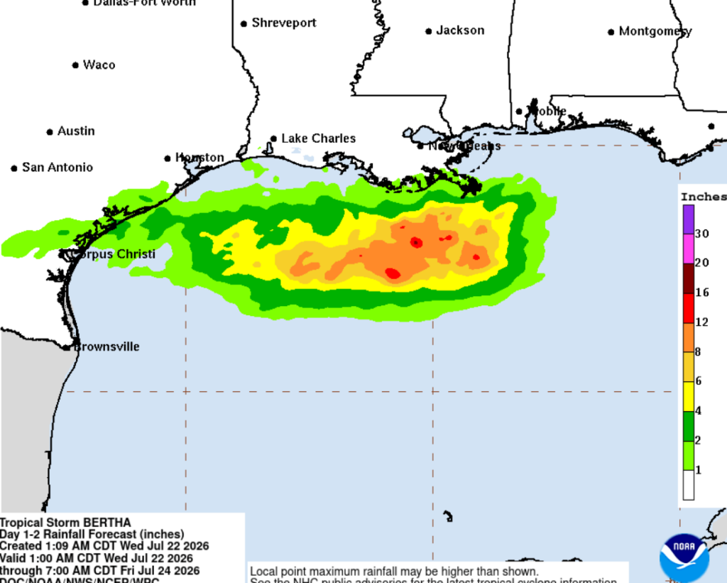
Below, we see the heavy rainfall totals contained mostly over the Gulf. This shows just how lopsided this storm is due to the strong wind shear, which, luckily for us, is keeping the heavy rainfall down south and off the Gulf Coast.
The system is then expected to weaken to a tropical depression Thursday evening near the Houston area, move further inland across Texas on Friday, and dissipate Friday evening.
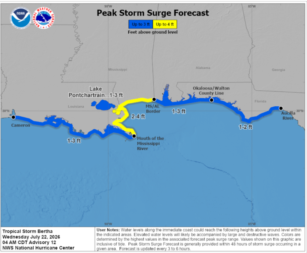
Although Bertha is expected to weaken, swells will continue spreading westward along the northern Gulf Coast, creating life-threatening surf and rip current conditions. Marine conditions will also remain hazardous near the storm, with peak seas around 15 feet currently occurring east of the center. Storm surge should be expected for coastal areas topping out at around 4 ft along the MS/LA coastline.
*The above information is based on the 2 AM EST Tropical Discussion from the NHC, and 4 AM CDT graphics*
Besides Bertha:
Taking a break from our current tropical focus, conditions will be very hot across our region, with the high today in Houston reaching a scorching 104 degrees!
Despite Tropical Storm Bertha moving across the northern Gulf, extreme heat is still affecting areas around the storm. A strong ridge over the southern Plains, combined with sinking air on the outer edges of Bertha, is promoting clear skies and allowing temperatures to soar. With abundant Gulf moisture already in place, heat indices are climbing well above actual temperatures, creating dangerous heat conditions across parts of the region.
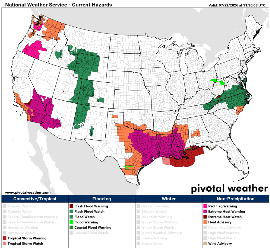
Looking at the NWS Current Hazards map, we are seeing a lot of activity in the South from Tropical Storm Warnings to Extreme Heat Warnings. It’s fixing to be a very toasty next few days across the South with this system in place, so be sure to stay hydrated and keep yourself cool, even if there is a Tropical Storm headed your way. Stay safe!
3 Day Travel Forecast
AIRPORTS
KIAH / KHOU (Houston) – Low delay risk due to weather, just very hot.
KSHV (Shreveport) – Low risk for delays.
KBTR (Baton Rouge) – Potential delays due to Tropical Storm Bertha.
KMSY (New Orleans) – Delays possible due to Bertha.
KJAN (Jackson) – Low delay risk from weather.
KBMH (Birmingham) – Delays are possible Thursday/Friday due to storms.
KMOB (Mobile) – Mild delay risk due to TS Bertha.
KATL (Atlanta) –Delays are possible Thursday/Friday due to storms.
KTLH (Tallahassee) – Possible delays from afternoon thunderstorms.
Highways
I-10: Impacts will be felt from TS Bertha as it moves west.
I-20: Mostly clear and hot with pop-up showers.
I-49: Mostly warm with a higher chance for severe storms further south.
I-55 & I-59: Hot temperatures with potential showers. Take caution Thursday/Friday as Bertha moves inland.
I-65: Warm with a higher chance for storms in the southern corridors.
I-75: Afternoon thunderstorms are to be expected, especially in FL.
3-Day City Forecast
Houston, TX: Wednesday (22nd): Very, very hot with a slight chance of showers. High 103°F, low 84°F.
Thursday (23rd): Partly sunny with a 20% chance for afternoon showers. High 98°F, low 82°F.
Friday (24th): Warm and sunny, mostly clear. High 96°F, low 82°F.
*Extreme Heat Warning in effect Wednesday 11AM-8PM*
Shreveport, LA: Wednesday (22nd): Very hot and clear. High 100°F, low 96°F.
Thursday (23rd): Hot and mostly clear. High 96°F, low 77°F.
Friday (24th): Warm and sunny, mostly clear. High 96°F, low 79°F.
Baton Rouge, LA: Wednesday (22nd): Hot with a chance for afternoon storms. High 99°F, low 80°F.
Thursday (23rd): 50% chance for daytime thunderstorms, otherwise hot and partly cloudy. High 94°F, low 78°F.
Friday (24th): Thunderstorms throughout the day. High 94°F, low 77°F.
*Extreme Heat Warning in effect Wednesday 10AM-8PM*
New Orleans, LA: Wednesday (22nd): Showers likely in the afternoon. High 94°F, low 81°F.
Thursday (23rd): Thunderstorms and showers throughout the day. High 92°F, low 80°F.
Friday (24th): Warm with a chance for T-storms. High 92°F, low 79°F.
*Extreme Heat Warning in effect Wednesday 10AM-8PM*
Jackson, MS: Wednesday (22nd): Partly sunny with potential afternoon storms. High 99°F, low 76°F.
Thursday (23rd): Mostly sunny with a 30% chance for afternoon showers. High 94°F, low 74°F.
Friday (24th): Warm and sunny with potential afternoon T-storms. High 95°F, low 75°F.
Birmingham, AL: Wednesday (22nd): Mostly sunny with afternoon storms likely. High 93°F, low 75°F.
Thursday (23rd): Rain and thunder for most of the day. High 90°F, low 73°F.
Friday (24th): Showers with potential T-storms. High 90°F, low 75°F.
*Heat Advisory until 9PM Wednesday*
Mobile, AL: Wednesday (22nd): Showers and thunderstorms. High 93°F, low 79°F.
Thursday (23rd): Rain and T-storms. High 92°F, low 77°F.
Friday (24th): Mostly cloudy with a chance for T-storms. High 93°F, low 78°F.
*Coastal Flood Advisory until Thursday 10AM*
Atlanta, GA: Wednesday (22nd): Partly sunny with potential afternoon storms. High 90°F, low 74°F.
Thursday (23rd): Thunderstorms throughout the day. High 88°F, low 72°F.
Friday (24th): Showers and thunderstorms. High 85°F, low 72°F.
Tallahassee, FL: Wednesday (22nd): Breezy with occasional heavy showers. High 90°F, low 76°F.
Thursday (23rd): Partly cloudy with afternoon showers. High 91°F, low 74°F.
Friday (24th): Warm and sunny, mostly clear. High 93°F, low 75°F.


